 |
| Stuart Range from Navaho Peak |
13 miles round trip, 4200 feet elevation gain
Difficulty: Strenuous
Access: Short stretch of poor gravel road to trailhead; Northwest Forest Pass required.
The lofty summit of Navaho Peak is a stunning location to observe the sunny side of the Cascades. On a clear day, this perch high in the Teanaway offers close-up views of the peaks of the Enchantments, the Alpine Lakes Wilderness, Kittitas Valley, and Mount Rainier. The price for this panorama of Washington mountains is a long approach along Stafford Creek to Navaho Pass coupled with a steep and punishing final climb to the summit. It's certainly not for all hikers, but those accustomed to long and steep hikes will be rewarded with a tumbling creek, scattered wildflowers, meadows, and a chance to glimpse the glistening granite of the Stuart Range.
I hiked this trail with two friends on a beautifully clear and not-too-hot Sunday in June, at the end of numerous days of rain. We made the two hour drive out from Seattle via I-90, leaving the interstate at Exit 84 for Route 903. We followed 903 through Cle Elum; the road turned into Route 10 after leaving town. About three miles past the town, we stayed to the left to head onto Route 970 in the direction of Wenatchee. Another four miles on, we turned left onto Teanaway Road and followed the paved but narrow road along the Teanaway River, with good views of both the Teanaway and Stuart Ranges appearing before us. The paved road changed to a good gravel when the road entered Okanogan Wenatchee National Forest; we followed the gravel road for a little over a mile past a bridge over Stafford Creek to the junction with NF-9737. Here, we took the right fork and followed a bumpy, pothole-filled dirt road to the trailhead, staying straight when we reached the junction for Standup Creek. The Stafford Creek Trailhead was reasonably well marked; parking there required a Northwest Forest Pass.
The trail began on the east side of Stafford Creek and headed off into the open woods parallel to the lively stream. We found some beautiful blooming tiger lilies along the trail.
 |
| Tiger lilies along Stafford Creek |
The trail climbed steadily but never very aggressively for the first two miles or so, staying just uphill of Stafford Creek for much of the way.
 |
| Stafford Creek tumbling through the forest |
The trail maintained a constant but never particularly steep climb up to the four mile mark on the hike, passing alternately through forest and partially open meadows with views of the rocky peaks of Teanaway that bounded the Stafford Creek basin. At the junction with the trail to Standup Creek, we stayed to the right. The trail embarked on a set of switchbacks, climbing high above the basin below in the forest. Further down, the trail came out onto a large meadow, one of the most lush spots on the hike; the trail circled around the meadow, delivering pretty views of Earl Peak and other ridges of the Teanaway. This appeared to be a popular camping spot: a few backpackers had set up along the edges of the meadow.
 |
| Meadow high up in Stafford Creek valley |
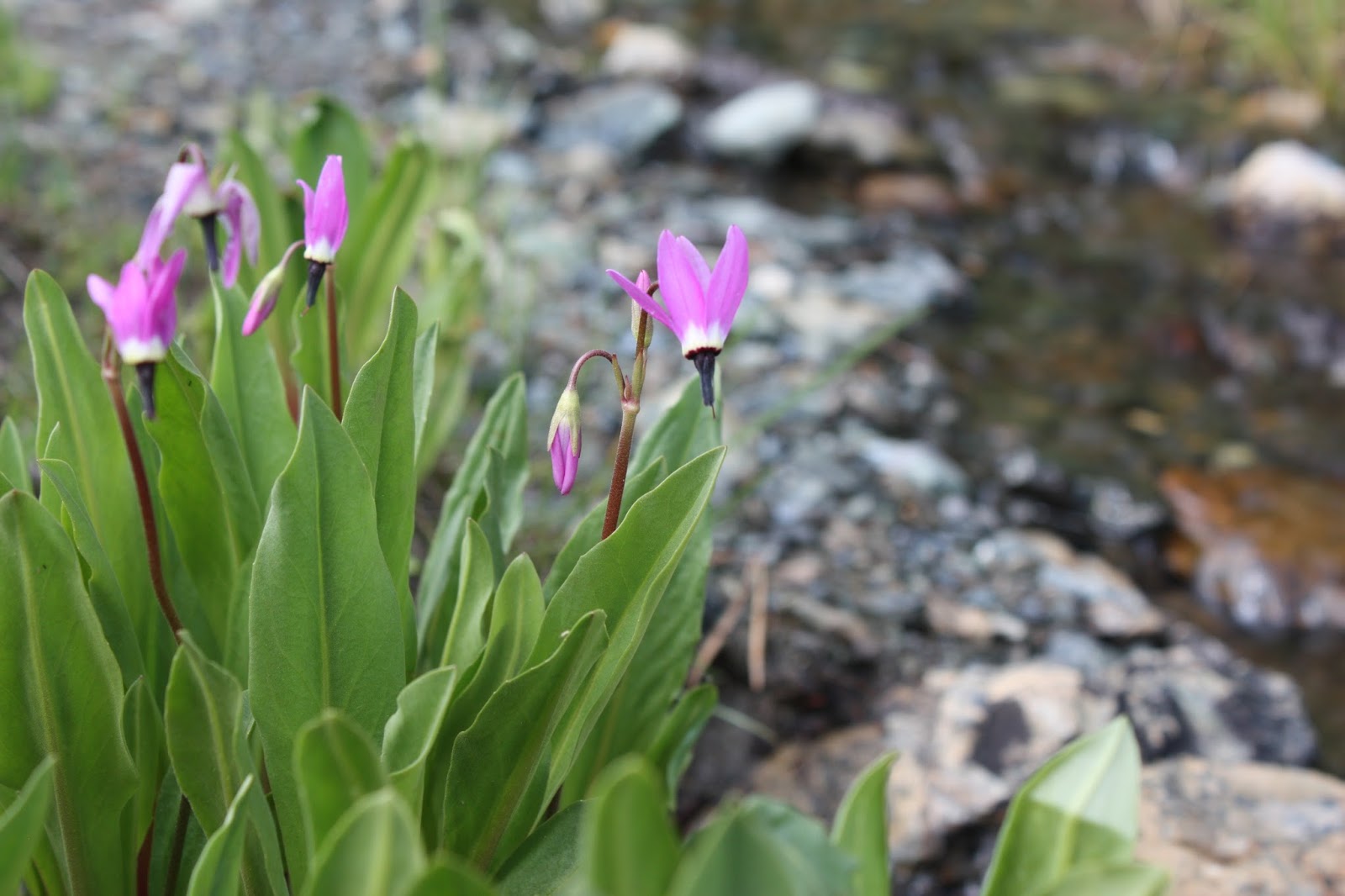
Past the meadow, the trail continued uphill, soon passing Stafford Creek near its headwaters. At the stream crossing, we spotted some beautiful blooming shooting stars.
 |
| Shooting stars near Stafford Creek headwaters |
Soon after the stream crossing, the trail entered a remarkable barren moonscape, following a rocky ridge uphill with open views in all directions. The ridge was surprisingly devoid of life: as we were still well below the treeline, it wasn't clear why there were neither trees nor meadows on this part of the mountain.
 |
| Barren mountainscape near the pass |
At the end of the barren ridge, the trail entered a grassy slope with blooming paintbrush and then made a final switchback before coming to Navaho Pass. Reaching the pass was an extraordinary visual experience: as we came to the saddle, the craggy, snowy peaks of the Stuart Range emerged, forming a wall north of us across the valley of Ingalls Creek. A sign at the pass indicated that we stood on the boundary of the Alpine Lakes Wilderness, one of the most heavily used and celebrated wilderness areas in the entire National Wilderness Preservation System. A stand of alpine larches lay north of the pass, sporting new spring foliage.
 |
| Stuart Range from Navaho Pass |
 |
| Trail at Navaho Pass |
From Navaho Pass, we began following County Line Trail east (to the right). The trail was clearly defined but steep; a few hundred meters past the pass, the summit trail split off from the County Line Trail at an unsigned junction. We took the left fork at every possible junction to ensure that we stayed close to the ridge and thus stayed on the route to visit the summit.
As we hiked up, we noticed a double rainbow arching across the sky, stretching through a set of high cirrus clouds.
 |
| Clouds and rainbows above Earl Peak |
Mountain views also expanded as we ascended. First Mount Adams and then Mount Rainier appeared to the south, massive Cascade volcanoes that dominated their surroundings. The sharp peak of Mount Stuart, one of the tallest non-volcanic peaks in the state, emerged at the western end of the Enchantments as we ascended from the pass.
 |
| Twisted pine and Mount Stuart |
The final stretch of trail that pushed to the summit was extraordinarily steep at points, ascending 1000 feet in about half a mile. At many points, the trail ascended without switchbacks through slopes of loose rock; although not particularly dangerous, the trail was nonetheless a little unpleasant. We paused often, out of breath as we ascended towards the 7223-foot high summit.
After passing a few patches of snow on the highest slopes of Navaho, the trail finally brought us to the summit, a fairly compact area with room for just a few groups to sit. The summit panorama was everything I could have expected from a high peak view: the sweeping vista encompassed everything from the arid Columbia Basin, Ellensburg in the Kittitas Valley, the Goat Rocks and Mount Adams, the clouds building on Mount Rainier, the jumble of craggy peaks near Mount Daniel and Hinman, the closer-in summits of Ingalls Peak and Mount Stuart, and the granite spine of the peaks lining the Enchantment Basin.
 |
| Mount Adams and Goat Rocks |
 |
| View towards the desert |
We took a long rest on the summit before retracing our steps for the long return to the trailhead. As we hiked at the height of summer, just a few days before solstice, we had sun and quite late that night, which was extremely fortunate: as we approached Snoqualmie Pass on our way back into Seattle, we discovered that our car had a flat tire. A good Samaritan allowed us to borrow a wrench after we pulled into a gas station at the pass, allowing us to change out the flat for a spare tire and make it back to Seattle along a slow collection of back roads.


No comments:
Post a Comment