Showing posts with label summit. Show all posts

Tuesday, December 12, 2023

Timber Top

Cone Peak and the Big Sur coast from Boronda Ridge
6 miles round trip, 2550 feet elevation gain
Difficulty: Moderate-strenuous
Access: Paved road to trailhead, no fee required

The steep trail along Boronda Ridge to the summit of Timber Top offers some of the finest views of California’s Big Sur Coast. This hike up an exposed, grassy ridge that rises precipitously from the Pacific offers sweeping views out onto the ocean and both north and south along the coast, with a summit view that extends from Point Sur to Cone Peak. As a bonus, this extremely scenic hike pulls few visitors despite being in an extremely popular stretch of the California Coast, helped in part by an unmarked trailhead. The precipitousness and openness of this terrain has its drawbacks though: the Boronda Trail is very steep throughout and the exposed ridge can become an oven under direct sun. Winter and spring are the best seasons, when the vegetation is greener and temperatures are moderate; summer conditions are generally too punishing for visiting this ridge’s coastal panoramas. While lovely, this hike also has far less variety than hikes such as Vicente Flat or the Cruickshank Trail, as the Boronda Trail eschews the redwood forests that are common along many Big Sur hikes.

The Boronda Trail to Timber Top is less brushy than the average Big Sur trail, although there are still stretches around the start and at the summit where vegetation can close in around the trail. Thus, poison oak is somewhat less of a concern here than elsewhere in Big Sur, although ticks remain a concern along the grassy trail. Hiking poles can help ameliorate the extremely steep descent on the return leg of the hike.

I hiked the Timber Top with a group of three friends on a sunny and warm February Sunday. To reach the trailhead, which is between the village of Big Sur and Julia Pfeiffer Burns State Park, we followed Highway 1 south from the Monterey Peninsula past the village of Big Sur. A half mile after passing COAST Big Sur café, we pulled over and parked along the ocean side of the road, across Highway 1 from an unmarked trailhead with a gate. There was no signage whatsoever for the trailhead, so it was necessary to come with knowledge of where to find it. There was parking for over 20 cars on either side of the road, although I had no trouble finding parking when I came. There are no bathrooms at the trailhead.

Crossing to the east side of Highway 1, we passed through the gate to start up the Boronda Trail. The road trace of the Boronda Trail started out in a greener patch of trees but almost immediately climbed out and emerged onto open grassy slopes. A steady if not yet aggressive ascent quickly lifted the trail above Highway 1 and by the time we reached the trail’s second switchback turn at a quarter mile into the hike, there were great views over the beaches along the Big Sur Coast below and the ridges that dropped to the coast to both the northwest and southeast.

Overlook of a Big Sur beach
The trail used a few switchbacks over the next few hundred meters to climb up the ocean-facing slopes of the Santa Lucia Range, with lovely views along the coast that extended all the way to Pfeiffer Point in the northwest. As the trail turned inland for a stretch, we caught our first glimpse of the Coast Ridge ahead of us, with Timber Top one minor summit along that crest. The high slopes of the ridge were generally dry and grassy but we could also see forests of coast redwoods filling the gullies eroded into the mountain slopes.

View over Highway 1
At 0.8 miles from the trailhead, the Boronda Trail returned to the spine of Boronda Ridge, ascending steeply uphill along this exposed, grassy ridge. An aggressive stretch of uphill brought us to a grove of oaks on the right side of the trail that provided some welcome relief from the intense sun on the exposed slopes. The views here began to extend much farther south along the coast, encompassing miles of Santa Lucia ridges dropping down to the blue Pacific.

Magnificent coastal views along the Boronda Trail

Highway 1 winds along the Big Sur coast
This stretch of trail featured the most direct views of the coast, as the trail was following a ridge that paralleled the coast. The higher that we hiked, the more spectacular and precipitious the drop down the steep slopes of Boronda Ridge to the Pacific. At points, it almost seemed as if we could look straight down to see Highway 1 and the Ocean. The astounding views made the steep and direct ascent feel easier than it actually was.

Big Sur Coast from Boronda Ridge

Overhead view of Highway 1 and the Big Sur coast
At 1.4 miles, the trail made a sharp right turn and began following the ridge inland. The coast became more distant, although from our high vantage point now over 1800 feet above sea level we could gaze far out onto the Pacific. The trail continued its steep uphill climb along the ridge, although the high crest of the Coast Ridge now dominated the view before us. Golden eagles circled overhead, scanning the ridges and canyons for prey.

Golden eagle flies over Boronda Ridge
At around 2 miles into the hike, the trail passed through a set of switchbacks that dipped the trail into a wooded ravine, which provided a welcome respite from the constant sun on the open slopes. The top of the switchbacks brought the trail back to the backbone of Boronda Ridge, which continued its grueling and endless descent towards Timber Top.

Boronda Trail
The trail's steep ascent along a ridge put us above one of Big Sur's signature lush coastal canyons. The canyon to our north, like many along the Big Sur coast, nestled a handful of coast redwoods. The coast redwood is the tallest tree species on the planet but the specimens around Big Sur are generally much smaller, as Big Sur is the far southern end of the species' range.

Redwoods and the Pacific
The contrast of the lush canyons and the arid ridgelines was nowhere more stark than a stretch of trail where I found a handful of agave blooming under the hot sun. Only in Big Sur do climate zones intersect in such a way that coast redwoods- which demand moisture to grow- can coexist within a few hundred yards of desert succulents.

Agave
At 2.5 miles, the trail flattened out a bit and wrapped around a wooded gully before it returned to the spine of the ridge for a final ascent. The constant uphill in exposed conditions made the ascent up to this point quite challenging and would likely make the conditions intolerable on hot summer days.

Approaching the summit of Timber Top
A final push up a last steep, grassy rise brought me to the flatter region atop the ridge, where the trail turned to the right and passed through a wooden fence. Just before crossing the fence, I had the very best views of the hike: from this point, I could gaze over 70 miles out onto the Pacific Ocean and could see down the rugged coast all the way to Cone Peak, the highest point directly along the Pacific coast in the contiguous United States. Cone Peak rises a vertical mile from the Pacific in less than 3 miles from the coast.

Big Sur Coast from Boronda Trail

View over the Pacific
The trail petered out at Timber Top Camp, just under 3 miles from the trailhead. Here, there was a grill and picnic table and a grassy area for tents. A faint path continued beyond Timber Top Camp- it was worth taking this path to get closer to the high point on Timber Top to unlock slightly wider views. The path was quite brushy and led uphill for another hundred meters, passing a water tank and then reaching a small rocky outcrop along a madrone-topped ridgeline. We ended our hike here: the rocks provided a pleasant, tick-free resting spot with nice views.

From this rocky outcrop, we had partial views of the ocean and Cone Peak that we had enjoyed on the way up; the vista in the direction of the ocean was not impressive as the many views that we had on the Boronda Trail. However, the view was wider here and encompassed other portions of the Big Sur Coast. Notably, we could see much of the coast to the Northwest: Pfeiffer Point’s remarkable headland, the faraway almost-island of Point Sur, and the tall peaks of Mount Manuel and Cabezo Prieto rising on the other side of Big Sur River’s canyon. Towards the interior of the Ventana Wilderness, we enjoyed views of the rocky forms of Kandlbinder Peak and Ventana Double Cone; the rest of the Santa Lucia Range was more rounded and chaparral-covered and was somewhat less impressive.

Pfeiffer Point, Point Sur, and Mount Manuel

Point Sur and the Coast Ridge Road

Cone Peak and the Coast Ridge Road from the summit of Timber Top

Ventana Double Cone from the summit of Timber Top
We enjoyed these remarkable views of Big Sur and Ventana Wilderness before leisurely backtracking downhill to the trailhead and returning to the Bay Area for a well-deserved all-you-can-eat hot pot. All in all, I enjoyed this hike immensely. While lacking the diversity of scenery of many other Big Sur hikes, Timber Top's stellar views still make this one of the best hikes along this stretch of the California coast.

Wednesday, August 23, 2023

Snow Mountain

Southerly views from the summit

16 miles round trip, 4300 feet elevation gain
Difficulty: Strenuous, stream crossing involved
Access: Narrow paved road to trailhead, no fee required

Snow Mountain is the first peak of California's Coast Range north of San Francisco to exceed 7000 feet in elevation and thus is a particularly prominent mountain in the range; its name derives from the fact that the peak is usually snow-covered through the winter and spring and it is the northern namesake landmark of Berryessa-Snow Mountain National Monument, which was established in 2017. These factoids about Snow Mountain may make it an appealing destination; the summit itself, however, is hardly worth the effort necessary to reach it. The approach from the Deafy Glade trailhead is long, grueling, and frequently very hot and passes through ghastly areas that were incinerated by the Ranch Fire in 2018. Summit views are nice, but Snow Mountain is ultimately far from being a scenic highlight in a state that is home to the Trinity Alps, the Cascades, the Santa Lucia Range, and the High Sierra. Hikers who love tagging notable high points may still find this hike rewarding, but most hikers will find better value hiking elsewhere in the state.

The trail from Deafy Glade requires crossing Stony Creek; the level of the creek can be quite high in spring and may make the hike less safe or even impassable. I hiked in July and found the creek level to be fine; in most years, the creek crossing should be manageable in May or later, although you should check the latest conditions before hiking.

The hike consists of four major portions: an initial mile of relatively flat hiking from the Deafy Glade Trailhead to Stony Creek, three miles of morale-busting ascent after the creek crossing that form the bulk of hike's uphill, a little over 2 miles of continued ascent along the Summit Springs Trail through the 2018 Ranch Fire burn area, and a final mile and a half through a subalpine landscape to the summit.

The trailhead for Snow Mountain is a surprisingly long drive from the Bay Area: it's about a 3.5 hour drive from San Francisco. To reach the Deafy Glade Trailhead from I-5, I left the freeway at Exit 586 and followed the Maxwell Colusa Road west through the town of Maxwell, at which point it turned into the Maxwell Sites Road. I followed the road into the mountains and then through the town of Sites, at which point it turned into Sites Lodoga Road. Sites Lodoga Road traveled through the mountains for 14 miles to reach Lodoga, where I turned right onto Lodoga Stonyford Road. Another 8 miles along this road through a broad valley brought me to Stonyford, where Lodoga Stonyford Road ended at its junction with Market Street next to the Stonyford General Store. Turning left onto Market Street, I headed north just two blocks before turning left again onto Fouts Spring Road. The final 13 miles of driving were along Fouts Spring Road, which entered the Coast Range and became extremely windy, taking about 40 minutes to travel. The road remained paved the entire time and I arrived at the trailhead, a small pull-off on the right side of the road, just under a mile after passing the Dixie Glade Campground. The trailhead is not well marked, there is limited parking, and there are no restrooms, as this is an off the beaten path hike. 

The Deafy Glade Trail followed a road trace west from the Deafy Glade parking area, staying level and contouring along the side of the mountain through the forest as the Fouts Spring Road continued ascending just uphill from the trail. Although road traces are generally easy to follow, the trail here was extremely brushy throughout and overgrown in parts, making it both a challenge to move through the vegetation and at times a little hard to follow. I recommend long pants to avoid picking up ticks here. The first mile of the trail was a very gradual descent as the Deafy Glade Trail traveled towards its crossing of Stony Creek. As I approached Stony Creek, I began to catch glimpses of Deafy Rock, a massive outcrop, across the creek, although there were no clear views of the rock due to the tree cover. The gradual descent steepened on the final approach to Stony Creek and at one mile into the hike I came to the creek.

Stony Creek
The environs around Stony Creek were lush and green, a stark difference from the terrain that would come ahead. The creek is bit too wide and deep to be rock-hopped, so I switched out for some sandals to cross the creek, where the water came up halfway up my calf in July.

After crossing the creek, the Deafy Glade Trail immediately embarked upon the hike's primary climb. After curving into a small ravine, the trail used a direct and brutal angle of ascent to gain the crest of a minor ridge. The trail then followed the backbone of this ridge directly uphill and quickly lifted me above the creek. At one point early along this ascent, a social trail branched off to the right that led to a rare view of massive Deafy Rock rising above the forested valley of Stony Creek.

Deafy Rock
A third of a mile and 300 feet of ascent after crossing Stony Creek, the trail came to an open meadow surrounded by trees. The trail skirted the eastern side of the meadow all while ascending and I spotted a handful of wildflowers that had bloomed into July; it was clear that the area would've been greener and sported more flowers earlier during the year. After the northeastern corner of the meadow, the trail turned sharply uphill and began the soul-sucking ascent up Morale Buster Hill. 

Meadow near Deafy Glade
Over the next 1.2 miles, the trail ascended nearly directly up the slopes of Snow Mountain. The trail through the forest here was often brushy and I almost lost it on one or two occasions, but its general route along the top of a minor ridge made it a bit easier to relocate when I lost the path. It's best to do this hike as early in the morning as possible during the summer, because this ascent can become quite hot later in the day. This was one of the more brutal ascents that I've dealt with in California and a big part of the reason I classified this hike as being strenuous.

At 2.6 miles from the trailhead and more than 1500 feet of uphill, I got some slight relief from the intensity of the ascent as the trail began to switchback with a slightly more moderate grade. The uphill didn't stop, though, continuing through a set of switchbacks until the trail gained the South Ridge of Snow Mountain at 4.2 miles and came to its junction with the Summit Springs Trail.

By the time I reached the junction with the Summit Springs Trail, I had traveled just over half of the distance from the Deafy Glade Trailhead to Snow Mountain's summit but had completed nearly 2500 feet of elevation gain. From the manzanita-covered ridge, there were the first significant views of the hike, encompassing the peaks of the Coast Range to the south and to the west as well as the Central Valley to the east and High Rock above. I took the right fork at the junction to follow the Summit Springs Trail north towards Snow Mountain; the left fork led downhill to an alternate trailhead that is much makes for a much shorter hike to Snow Mountain but requires much more driving and a 4WD vehicle to access.

Summit Springs Trail
I followed the Summit Springs Trail north along a ridge with wide open views, continuing to ascend steadily. The openness of the Summit Springs Trail here made the terrain much hotter: in fact, upon leaving the forest of the Deafy Glade Trail, there would be no more extended areas of shade along the hike at all.

After a short stretch of hiking atop the ridge, the Summit Springs Trail peeled off to the west side of the ridge. While the entirety of the terrain of this hike burned in the 2018 Ranch Fire, part of the larger Mendocino Complex Fire, the damage was limited and often non-obvious along the Deafy Glade Trail: however, the upper reaches of Snow Mountain burned intensely and the effects of the fire became obvious along the Summit Springs Trail. At 4.5 miles, the trail turned into a small ravine that was once forested but was now just a graveyard of charred trunks. While brushy vegetation had sprouted in the four years since the fire, it seemed clear that recovery of the full forest would take a while.

Hiking through the burn area of the Ranch Fire
The Mendocino Complex Fire in 2018 was the largest wildfire in California's history when it happened, although it would be dwarfed by the megafires of 2020 and 2021 soon afterwards. Over 450000 acres burned between the Clear Lake area through Snow Mountain; combined with the August Complex Fire in 2020 and the Monument Fire in 2021, nearly every acre of the Coast Range between Clear Lake and the Trinity Alps were torched, a slow-motion conflagration of astounding proportions that illustrates how the climate of these mountains has changed.

Deer amidst Ranch Fire devastation
Numerous switchbacks through the burn area brought me out to the spine of the ridge again. Here, I had a grand view of High Rock, an outcrop that marked the southern end of the higher elevation cluster of hills and peaks around Snow Mountain. Beyond High Rock, I could see back out to Central Valley and the Sutter Buttes, a tiny, circular collection of hills in the heart of the valley between Yuba City and Oroville. On a clear day, it would be possible to see the Sierra Nevada and spot peaks like the Sierra Buttes, but the day of my hike was a standard summer day, meaning that a layer of haze covered the Central Valley and restricted longer-range views to the east.

High Rock and Central Valley views
The trail flattened out for a brief stretch as it reentered another charred ghost forest. At 5.8 miles, the trail descended slightly and came to a large meadow. A few trees surrounding this meadow had survived the fire, making for a tiny oasis of green in an otherwise barren and charred landscape. During the spring snowmelt, this meadow contains the small Cedar Pond, but the pond had disappeared for the summer by the time of my hike.

Cedar "Pond" amidst the devastation of the 2018 Ranch Fire
The trail skirted the eastern end of the meadow and delved back into the charred forest. I ascended steadily through one small ravine; at the top of that ravine, I came into another burnt ravine and followed it up to a saddle at 6.5 miles.

The extended ascent that started from the crossing of Stony Creek ended here. Reaching the saddle, I could finally see the summit of Snow Mountain for the first time, about a mile north from where I stood. From here onward, the burnt forest thinned out and was replaced by chaparral and subalpine meadows. The trail descended briefly after leaving the saddle and then stayed level for a while as it crossed through a number of clearings with sweeping views east into Central Valley. At 7.2 miles, the trail reached a basin at the base of Snow Mountain's east peak and began ascending again along a small stream.

This was the most scenic part of the hike, with scenery that more closely resembled that of the state's famed alpine regions than the standard Coast Range scenery. There were still many wildflowers blooming in the meadows here and the sparser trees here appeared to have largely escaped the fiery fate of the forest near Cedar Pond. 

Meadow and the Snow Mountain East summit
The Summit Springs Trail led uphill to a saddle between Snow Mountain's East and West summits at just over 7.5 miles. The East Peak was the mountain's true high point, so I turned right and followed the open, rocky ridgeline towards the summit. The trail was not always obvious here but my objective was obvious enough that I knew to make a beeline for the summit along the ridge.

Ridge leading to the summit of Snow Mountain
A few switchbacks assisted the final push to the summit. While the rocky summit looked barren from a distance, I found it brimming with wildflowers when I got closer, which added some much needed color to a landscape that showed too much wildfire devastation.

Wildflowers near the summit
After 8 miles of hard hiking, I arrived at the broad plateau that made up the summit of Snow Mountain East Peak. Walking to the various corners of the plateau, I pieced together a far-ranging panorama of the Coast Range and the Central Valley. The Sutter Buttes, nearby Saint John Mountain, and Mount St. Helena were notable landmarks in the view. On a clearer day, hikers at this summit would likely be able to see the Sierra Buttes, Lassen Peak, and Mount Shasta. The view was lovely, but much of the landscape that I could see was brown from either the summer sun or the Ranch Fire, so it ultimately compared unfavorably to summit views that one can find in the Trinity Alps or the Sierra Nevada. I had the summit completely to myself (in fact, I did not see another human on the trail all day) and had a nice time, but did wonder whether it was worth the intensity of the hike and the summer heat to reach it.

View into the Central Valley and Sutter Buttes from the top of Snow Mountain

View north along the crest of the Coast Range

Looking south towards Mount St. Helena

View towards Saint John Mountain and the Central Valley

Wednesday, August 9, 2023

Eagle Rock (Tahoe)

Freel Peak and Lake Tahoe from Eagle Rock
0.8 miles round trip, 250 feet elevation gain
Difficulty: Easy, although a tad of scrambling may be needed at the summit
Access: Paved road to trailhead, no fee required

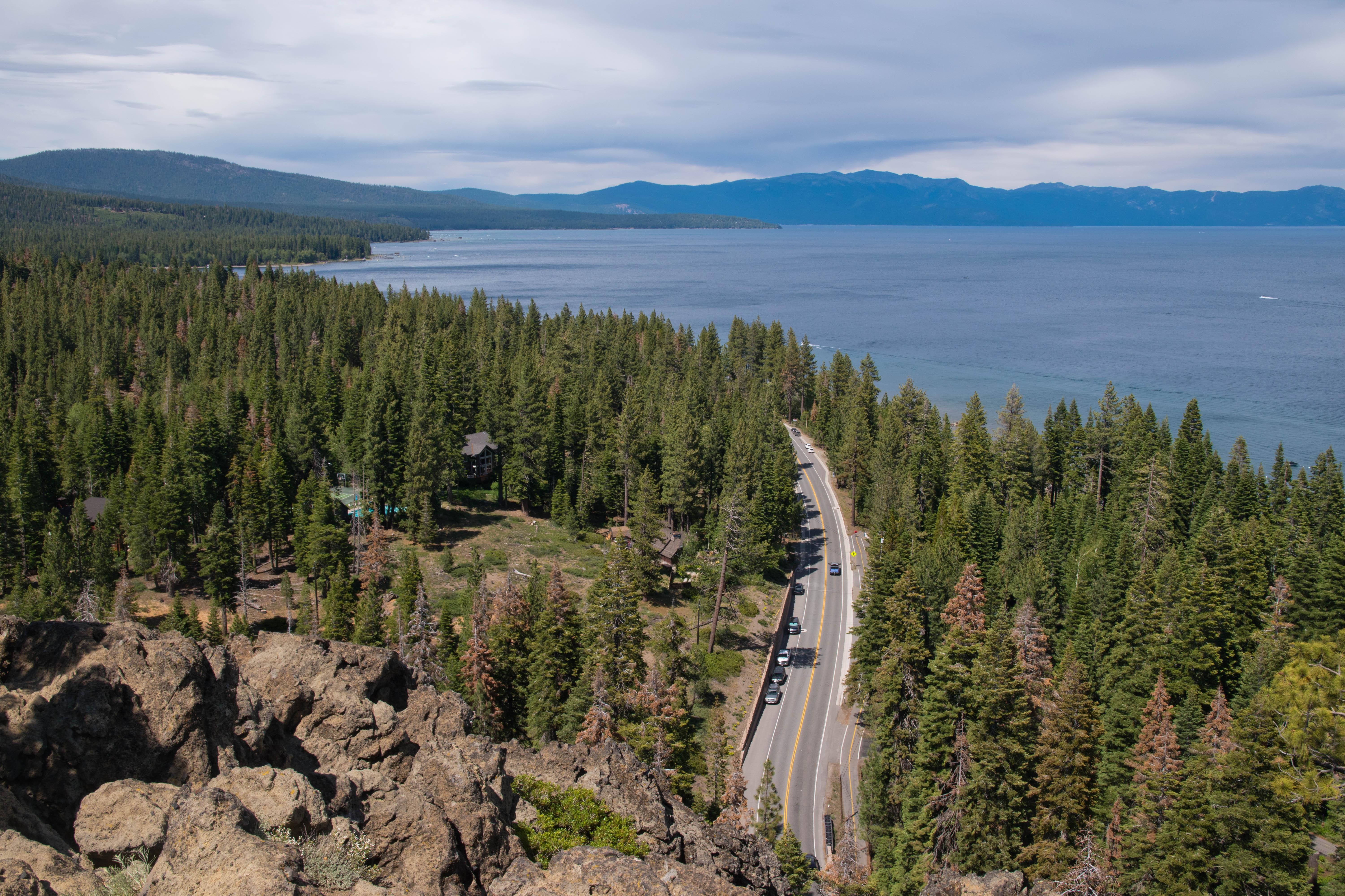
Eagle Rock is a massive outcrop on the west shore of California’s Lake Tahoe that provides lovely views of the blue waters of North America’s largest alpine lake while requiring a short hike of less than a mile round trip from the trailhead on Highway 89. This is a short but popular hike and it’s easy to see why when you’re at the summit: the sweeping views of the lake had here typically requires far more effort to reach. The trail is managed by the California Tahoe Conversancy, a California state agency that operates a number of tracts for recreation and conversation around Lake Tahoe.

I hiked Eagle Rock with Anna and a few visiting friends over July 4 weekend. The trailhead is a short drive from the Tahoe City area on the lake's West Shore and is about a 40 minute drive from South Lake Tahoe. Coming from Tahoe City, we followed Highway 89 south for 4.5 miles from the junction with Highway 28 and then came to the trailhead on the right (west) side of the road. Driving in, we could see Eagle Rock towering above the highway right before we reached the trailhead parking area. I encourage you to approach from the north, as it's far easier to pull into the roadside parking when driving southbound on Highway 89. There's room for parking for about at least ten cars here; the parking area is often full on summer weekends, but as the trail is short, turnover is pretty fast. There's no bathroom at the trailhead.

Leaving from the trailhead, the trail began to head west up the forested southern slopes of Eagle Rock. The trail was generally well graded through its early stretches but ascended steadily and reached the spine of Eagle Rock at 0.2 miles, at which point it made a wide turn to the east and began heading east along the northern slopes of the rock up towards the summit. At 0.3 miles, the trail broke out of the forest and onto a massive outcrop; the trail became very rocky here, with a bit of minor scrambling almost necessary at times to reach the top of the eastern face of the outcrop. The volcanic rock atop Eagle Rock was substantially rougher and more jagged than the smooth granite that is generally found elsewhere around Tahoe. The true summit was slightly to the west of where the trail ended, although the best views of Lake Tahoe were atop the cliffs above the east face of the rock.

The primary views from atop the cliffs of Eagle Rock extended in all directions but west. Lake Tahoe's placid blue waters lay below us to the east, separated from the rock by Highway 89 and the west shore's orderly conifer forests. From left to right, we could see many of the major peaks around the lake: Mount Pluto; the vast sweep of the Carson Range on the other side of the lake, which included the high summit of Mount Rose, the steep escarpment of Herlan Peak, and the barren summits of Freel and Jobs Peak; and the closer summits of Rubicon and Phipps Peaks in the Sierra Nevada, which rose above nearby McKinney Bay.

Highway 89 passes below Eagle Rock

Rubicon and Phipps Peaks rise above the blue waters of Tahoe
The main viewpoint was a bit crowded during our holiday weekend visit. To avoid the crowds and check out some alternative views, I made my way over to the true summit, just slightly west of the rock's main cliff face. The view of the lake from here was a bit limited but the view of the rock itself made up for it; there were also far fewer other visitors at the true summit.

Eagle Rock and Lake Tahoe
Eagle Rock is a volcanic plug- it is the eroded remnants of a former volcanic vent. The outcrop is a testament to the importance of volcanic activity in the geologic history of the Lake Tahoe basin. In fact, the formation of the lake itself is due to volcanic activity: the formation of Mount Pluto, the rounded volcano on the northern end of the lake, around 2 million years ago, resulted in lava flows that dammed the outlet of the valley between the Sierra Nevada and the Carson Ranges, creating the alpine dream that we know today as Lake Tahoe.

After enjoying the summit scenery, we descended the way we came to end our short but very scenic outing. While this hike is not one of the highlights in the Tahoe area, it was an enjoyable leg stretcher and a worthwhile hour-long excursion for visitors with some extra time during a Tahoe trip.

Wednesday, April 26, 2023

Kungsklyftan and Vetteberget

View of Fjallbacka from Vetteberget
2 km round trip, 70 meters elevation gain
Difficulty: Easy-moderate
Access: Paved, narrow road to trailhead; parking limited in Fjallbacka

The best view of Fjallbacka- one of the most charming and picturesque towns along Sweden's rocky Bohuslan Coast- is from the top of the great dome of Vetteberget, which overlooks the tidy red-roofed town and its nearby archipelago and fjords. While there are multiple routes to reach the top of Vetteberget, none is more dramatic than the Kungsklyftan- a deep gorge bisecting the rock of Vetteberget that leads to the staircase climb to this rocky hill's grand summit. While not particularly difficult, this hike does involve climbing quite a few stairs and some uneven footing and the conditions atop Vetteberget can be extremely windy. This is a must-do for all visitors to Fjallbacka and was one of the loveliest spots on the west coast of Sweden.

Fjallbacka is a small and indescribably lovely town along the Bohuslan Coast, just under two hours of driving north of Gothenburg. While it was quiet during my May visit- which is still during the off season- in summer it can apparently become quite busy as one of Sweden's most beloved coastal towns. Ingrid Bergman, the elegant Hollywood leading lady of the 1940s who starred opposite Humphrey Bogart in Casablanca, spent the later years of her life in this idyllic seaside town. 

Anna and I hiked through the Kungsklyftan and up Vetteberget during a May visit to Sweden. We stayed at the Bryggan Fjallbacka, which is in the heart of town and just steps away from the trailhead of the Kungsklyftan hike. For visitors just in town for the day, there are pay parking lots along Falkevagen up the hill from the center of town.

From the Bryggan Fjallbacka, we walked south along the waterfront, passing a monument to Ingrid Bergman. Right after passing the monument and a children's playground, we made a left and headed for an arched gateway at the base of the Vetteberget's cliffs: this was the start of the path through the Kungsklyftan. The path immediately began a steep, rocky staircase climb through the forested entrance to the Kungsklyftan gorge; there were nice views back down towards the Fjallbacka harbor.

At the top of the rocky staircase, the trail leveled out in the heart of the Kungsklyftan gorge. This narrow cleft in Vetteberget was extraordinarily dramatic: massive, house-sized boulders were lodged between the great vertical cliffs. The trail passed underneath the boulders, following wooden planks that made footing while traversing the rocky bottom of the gorge a little easier. 

Kungsklyftan
After 200 meters of hiking up the staircase and through the Kungsklyftan gorge, we arrived at the base of a wooden staircase. This staircase- built into the side of the cliff- ascended from the gorge up to the rocky summit plateau of Vetteberget. From the base of the staircase, the exit out the far side of the Kungsklyftan gorge was visible- we were just a few meters away from the houses on the south side of the mountain. Instead of exiting, however, we headed up the staircase.  

Stairway up Vetteberget
The wooden stairs were quite steep, so we had to pause for a break a little over halfway up; we were rewarded with ever-improving views. Below us lay the colorful houses of Fjallbacka, which spilled down the hill to the harbor, rose a myriad of rocky islands that make up the Fjallbacka archipelago. Beyond the farthest of the islands lay the vast and cold North Sea.

View from Vetteberget

Colorful Fjallbacka
The staircase ended at Vetteberget's summit plateau, where the trail faded out onto the granite. In May, the winds at the summit were intense, with a steady gale whipping across Vetteberget from the North Sea. However strong the winds were, the spectacular views made the views atop the staircase worth it: below us lay the idyllic seaside town, sandwiched between the cliffs and a fjord, with infinite rocky islands stretching towards the horizon.

Fjallbacka
The top of the staircase was not the high point of Vetteberget; the true high point of this rocky hill was unclear, but as the views off the sides of the cliffs were most interesting, missing the high point did not seem like anything to be concerned about. Instead, we chose to explore the northern side of Vetteberget to see if we could find views over the central part of Fjallbacka and its stately stone church. We could see a high point on the northern side of the rock but there was no direct path to reach it from the top of staircase- multiple areas of bushy vegetation made a direct traverse of the rocky plateau impractical. Instead, we followed the western cliffs of the mountain and then circled around to the viewpoint on the north side of the rock.

Fjallbacka Archipelago

Looking out into the Fjallbacka Archipelago
Arriving on the north side of Vetteberget, we had the most picturesque view of Fjallbacka. Seventy meters below us lay the red roofs and white walls of this coastal town, which was bounded by rocky cliffs on three sides and the sea by the fourth, with the town's great church rising behind it. The scenery from this viewpoint had some satisfying balance: on one side, a rocky landscape and on the other, the sea.

Fjallbacka from Vetteberget
I did this hike twice during my stay in Fjallbacka. The most straightforward return route from the summit is to retrace your steps down the Kungsklyftan, but an alternate route is to turn left and exit the south side of the Kungsklyftan. The trail ends on the residential street of Brandgatan; we followed Brandgatan downhill through the red-roofed houses until we came to Sodra Hamngatan by the water. We turned right onto waterfront road and followed it north along the base of Vetteberget until we returned to our lodging at Bryggan Fjallbacka.

In high tourist season, perhaps this hike is busier and somewhat less pleasant. During our cold and windy May visit, we had these views more or less to ourselves even though the town was just a stone's throw away. We both found Fjallbacka and the Bohuslan Coast to be charming and the views from Vetteberget were surely among the best views that we found along the coast. Recommended if you visit this corner of Sweden.

Wednesday, January 18, 2023

Mount Diablo North Peak

View into Livermore Valley
4 miles round trip, 1200 feet elevation gain
Difficulty: Easy-moderate
Access: Paved but windy road to trailhead, Mount Diablo State Park entrance fee required

North Peak is the oft-overlooked shorter sibling to the well-loved and ever-popular main summit of California's Mount Diablo, the iconic double-peaked mountain visible from much of the San Francisco Bay Area. Real estate agents in nearby Walnut Creek once promoted a false claim that Mount Diablo had the largest viewshed of any point on Earth after Kilimanjaro, but the fact that those claims were even somewhat believable gives you an idea of the sweeping panorama from the mountain. While a road leads to an observation tower crowning the main peak of Mount Diablo, 3557-foot tall North Peak is accessible only by hiking and is thus far quieter; although the summit experience at North Peak can be somewhat marred by the extensive collection of telecommunications equipment at the summit, the lovely panoramic views still make this an enjoyable hike. This hike is best in winter and spring, when there is less air pollution and the grassy slopes of Diablo are green.

I hiked North Peak on a clear February weekday, when the weekend crowds that descend on Mount Diablo State Park were absent. The trailhead can be accessed by either the North Gate or South Gate Roads into Mount Diablo State Park, which come from Walnut Creek and Danville, respectively. I arrived from Danville: I left I-680 at exit 39 and followed Diablo Road to the northeast, making a right turn after 0.7 miles to stay on Diablo Road. I followed Diablo Road for another 2 miles and then turned left at the junction for the Mount Diablo State Park Road; signs just before the junction indicated a turn for Mount Diablo State Park and the Athenian School. I followed this narrow paved road through a tony neighborhood before the increasingly windy road entered Mount Diablo State Park; I passed the entrance kiosk and then after 7 miles of driving from the turn on Diablo Road I came to a junction with North Gate and Summit Roads.

Turning right at the junction onto Summit Road, I followed Summit Road uphill for another 3.5 miles to a sharp, eastern-facing switchback just below the summit, where there were wide gravel pullouts on either side of the road. This unsigned parking area is the start of the hike to North Peak. New expanded bike lanes have eaten into some of the parking, but there's still room for ten cars or so to park. If you struggle to park here, you can continue uphill on Summit Road, park in the large lot near the summit of Mount Diablo, and follow the Summit Trail back to the this trailhead.

Leaving from the eastern edge of the switchback on Summit Road, the North Peak Trail led east across the open and grassy south slopes of Mount Diablo. On the very clear day of my hike, the views were absolutely expansive here: closer by, the rolling green grassy hills of Morgan Territory lay below, with the suburbs and shopping malls of the Tri-Valley beyond that and the Diablo Range peaks at Sunol and Ohlone Wildernesses rising beyond Livermore and Pleasanton. To the east, I could see clear across the Central Valley to the snowy peaks of the Sierra Nevada!

North Peak Trail wrapping around Mount Diablo
I followed the North Peak Trail gradually downhill as it wrapped around the south side of Mount Diablo's main peak. At one-third of a mile, the trail came to the southeast ridge of the mountain, a rocky spine leading towards the summit that featured the Devil's Pulpit, an enormous outcrop. Beyond the Devil's Pulpit, I could see all the way to the stone observation tower built atop Mount Diablo.

Devil's Pulpit and the observation tower atop the main summit of Diablo
The southeast ridge also offered sweeping views to the south and west, including some of the best views of San Francisco Bay on this hike. Much of the bay itself was visible, its waters glimmering in the sunlight. The Santa Cruz Mountains rose behind the Bay, with peaks such as Montara Mountain, Black Mountain, and Mount Umunhum clearly distinguishable.

View towards San Francisco Bay and the Santa Cruz Mountains
As the trail turned the corner around the southwest ridge, I found a great view of North Peak. From here, the trail ahead was clear: I could see the North Peak Fire Road that I would later follow running up the ridge of North Peak until eventually reaching the cluster of communications towers at the summit. Beyond North Peak, the watery veins of the Sacramento-San Joaquin Delta snaked across the Central Valley and even further back were snowy Sierra Nevada peaks.

North Peak across Prospectors Gap
After coming around the southwest ridge, the trail descended via a pair of short switchbacks and then entered a forest. Over the next two-thirds of a mile, the trail descended constantly, with more limited views; the final stretch of descent down to Prospectors Gap was quite steep.

One mile from the trailhead and after about 500 feet of descent, the North Peak Trail arrived at Prospectors Gap, a saddle between the main summit and North Peak. Here, the trail crossed Prospectors Gap Fire Road, which led downhill on either side of the ridge; across the road, I connected onto the North Peak Fire Road, which led uphill along a ridge towards the summit.

The North Peak Fire Road was very aggressive in its initial ascent up from Prospectors Gap, with some sections that were quite steep. The first half mile of ascent along the fire road generally stuck to the southern side of the ridge and provided more views out west and south to the main summit and the Tri-Valley. At 1.5 miles, the trail crossed over to the forested north side of the ridge, where the trail flattened out and provided some temporary respite; however, at 1.7 miles, the trail became extremely steep as it tackled the final push to the summit of North Peak. This stretch of the fire road was actually quite tricky to negotiate: gravel covering the fire road made the trail surface loose and slippery and the angle of the ascent was high enough that I was struggling to get traction with my boots. When this short hundred-meter stretch ended, I found myself arriving at the broad-sloped summit area, reaching the base of the telecommunications towers atop the peak at just over 1.8 miles.

The presence of so many towers on the summit certainly detracted from the scenery to a degree; the summit itself was best for views west towards Mount Diablo's main summit and towards the Tri-Valley. Pleasanton Ridge and Mission Peak rose at the far end of the Tri-Valley area, with Loma Prieta's distant but high peak visible behind them. 

Looking back to the main summit of Mount Diablo
View of the Tri-Valley, with Mission Peak and Loma Prieta in the distance
The most enjoyable part of the Mount Diablo North Peak view, however, was found from a small knoll to the northeast of the high point. I followed the fire road counterclockwise around the communications towers and found a social path leading towards a low prominent point along the north ridge. The path died out upon reaching a rockier section of this ridge; there were plenty of rocks here where hikers can relax and enjoy the views to the north and the east.

What lovely views! The Central Valley lay below me, the Sacramento-San Joaquin Delta clearly visible beyond the suburbs of Antioch. The Shiloh Wind Farm- a 500 MW project- was spread out across the delta, which is a wetland of extraordinary ecological diversity. Beyond the Central Valley rose the snowy Sierra. I could clearly make out Pyramid Peak near Lake Tahoe and could see a less distinguishable snowy mass stretching south towards Yosemite National Park. The isolated hills of the Sutter Buttes were visible in the middle of the valley to the north, with the snow-capped and rounded form of Lassen Peak, the southernmost of the Cascade volcanoes, just barely visible.

Suisun Bay lay beyond the nearby suburbs of Concord; a patch of oil refineries dotted the shoreline near the Carquinez Strait. The open pit of the Clayton Quarry is clearly visible, a mountain being deconstructed to make concrete in our cities. Mount St. Helena, Cobb Mountain, and even distant Snow Mountain rose to the north in the Coast Ranges. San Pablo Bay was visible in the distance, with Mount Tam's distinctive profile clearly visible. At the very edge of the view, I could see past the Oakland hills to the Golden Gate Bridge, the San Francisco skyline, and a flotilla of cargo ships waiting to be unloaded at the Bay's many ports.

View towards the Suisun and San Pablo Bays
The Central Valley and the Sacramento-San Joaquin Delta
San Francisco skyline rises behind the Oakland hills
Snowy Sierra Nevada rises over Sacramento-San Joaquin Delta
The view was sweeping enough that for a moment I could imagine that it could be the second largest viewshed in the world, as pamphlets in the mid-20th century claimed. This, of course, was hogwash invented to sell houses in Walnut Creek- Mount Diablo's viewshed is ultimately not even the second largest in California. Still, this was a grand panorama and I was glad to enjoy it all by myself on my hike. Weekends bring far more visitors to this park, so come early or come on a weekday to enjoy the views from Diablo's sibling peak.