Monday, May 27, 2013

Rocks State Park

King and Queen Seat
3.8 miles loop, 700 feet elevation gain
Difficulty: Easy-Moderate
Access: Paved road to trailhead, no entrance fee required

Hikers in the Baltimore area who don't want to drive out to Catoctin or South Mountain to go hiking can find a spot closer to home: Rocks State Park. This park sits in a particularly dramatic part of the Maryland Piedmont, in Harford County just miles from the Pennsylvania border. The trail I will describe is a loop hike that uses the White, Green, and Blue Trails in the state park. Driving time from Baltimore is less than an hour.

I headed out from Baltimore on an early May morning, leaving I-695 near Towson at Rte. 146, Dulaney Valley Road. I took Dulaney Valley Road north past the turnoff for Hampton National Historic Site (an interesting place to visit!) north past the bridge over Loch Raven Reservoir. After crossing the reservoir, I turned left to stay on Rte. 146, which turned into Jarrettsville Pike. I continued north on Jarrettsville Pike for about 15 minutes until reaching Rte. 23, Norrisville Road. I turned right at Norrisville Road and drove through Jarrettsville, staying straight at the principal intersection to get onto West Jarrettsville Road. I followed this road for 5 minutes until it started it making a big bend to the right; here, I turned left onto Old Federal Hill Road. I soon reached and turned right onto Chrome Hill Road, from which I had good views of pretty Maryland countryside. A few minutes later, I came to Rocks Chrome Road; I turned left onto this road, which dropped quickly downhill. At the end of the downhill, I turned left into the park headquarters for Rocks State Park.

I parked at the park headquarters and picked up a map there and began my hike. From the parking lot, the White Trail goes east to a second parking area before heading away from the road. Very soon past the second parking lot, there was a fork in the White Trail; I followed the right fork, which ascended a little over 200 feet in less than half a mile to gain the ridgeline of Rocks Ridge. The early spring forest was vibrantly green here.

White Trail ascending Rocks Ridge
Along the way, there was a bench at which tired hikers could take a break.

Once atop the ridge, the White Trail intersected the Red Trail. Here, I took the spur trail to the right, which led briefly downhill and out onto King and Queen Seat. King and Queen Seat form the namesake rocks of the park. This set of rocks towers above a water gap carved by Deer Creek. Unfortunately, King and Queen Seat (like Humpback Rocks near Charlottesville; and any set of road-accessible rocks) is a little too accessible, so graffiti decorated much of the rocks. However, they still formed an impressive natural sight. From atop the rocks, I had a decent view of the Harford County countryside and of the steep cliffs on the other side of the water gap. The rocks were apparently a ceremonial site for the Susquehannock who once lived in the area.

King and Queen Seat
I wasn't able to find a geologist on site during my trip, which was very unfortunate as the geology of the area seemed fascinating. Harford County is tens of miles away from the Blue Ridge anticlinorium- yet here, in the middle of the Maryland Piedmont, was a sharp and long ridge that seemed more reminiscent of the topography found in the Valley and Ridge. The rocks in the area were metamorphic- possibly some form of metasedimentary rock. Deer Creek must be quite an old creek: as it has sliced a water gap through Rocks Ridge, it likely predates the age of the ridge itself. If anyone is particularly familiar with the geology of this area, please let me know more about it!

From King and Queen seat, I continued counterclockwise on the White Trail. The trail descended briefly, passing a junction with the Purple Trail, which led down to the Deer Creek Rapids, before settling onto a northward extension of Rocks Ridge. This ridge was very enjoyable to hike: along the ridgeline, I found many bushes of mountain laurel, not yet blooming, and many wild azaleas, already blooming.

Wild azaleas on the White Trail
After continuing on about three-quarters of a mile from King and Queen Seat, I took a side trip down the Green Trail, which went past the site of a former iron works site to the Wilson Picnic area. The trail ended at the St. Clair Bridge Road; I walked through the picnic grounds to the side of Deer Creek, a minor river that was quite scenic. At the far east end of the picnic area, I could see an interestingly shaped truss bridge over Deer Creek.

Bridge over Deer  Creek at the end of the Green Trail
After hanging out around the picnic grounds for a short rest, I returned on the Green Trail to the White Trail. Here, the trail was mostly level for a while, only climbing occasionally; mountain laurel, a few weeks before blooming, crowded much of the area around the trail. At times the trail was rocky. The trail maintained some distance from Deer Creek, moving gradually further away. At one point, the trail passed a former charcoal kiln. Eventually, the trail climbed a bit and crossed a road leading up to Rocks Ridge. Past the road, the trail became very rocky; it was not surprising that this park was named Rocks. About 2 miles into the hike, the trail intersected the Blue Trail. I took the Blue Trail, which descended for about 0.3 miles before coming to a nature loop. This was a very enjoyable part of the hike: a number of interpretative nature signs were scattered along the loop. The signs pointed out and explained ferns, black walnut trees, skunk cabbage, and mountain laurel; they also highlighted some human artifacts left over from pre-park agriculture around Rocks Ridge. Along the loop, I crossed the a small stream running through that valley twice on wooden bridges.

Human artifacts along the Blue Trail nature loop
After looping around, I hiked back up the Blue Trail to the White Trail. From this junction, the White Trail made a long switchback up to the top of Rocks Ridge. The hiking here was not more than moderately difficult; the climb was fairly gentle. Atop the ridge, the White Trail intersected with the Red Trail; from there, I followed the White Trail a little over half a mile back to the original trail junction and back to the parking area at Park Headquarters. During the final descent, I saw deer, the only notable wildlife on the hike.

I'll end this post by commenting on two other areas in Rocks State Park that I visited after completing this loop. My first stop was at Deer Creek Rapids, which was very close by to the visitor center: to get to it, I continued on Rocks Chrome Rd. to Rocks Road (Rt. 24), which I took north to a roadside parking area. From there, I followed a short path down to the rapids, which were quite impressive.

Rapids on Deer Creek
The last spot that I visited was about 10 minutes north of the main area of the park on Rt. 24- the Falling Branch area. To get there, I took Rt. 24 t St. Mary's Rd., turned left onto St. Mary's, and very soon afterward turned right onto Falling Branch Road. After getting on Falling Branch Rd, I soon came to a parking area for the Falling Branch area of Rocks State Park. From the parking area, I took a trail that led a fifth of a mile to Kilgore Falls, which at 19 feet tall is apparently the second tallest single-drop waterfall in Maryland. Kilgore Falls was very pretty, so I spent some time here enjoying the scenery before heading back. Once again, I was puzzled by the presence of a waterfall here- Piedmont waterfalls are usually limited to just being rapids near the fall line. But this was a pleasant surprise! Baltimore, it seems, has much more beautiful natural scenery and good hiking near it than I had previously imagined.

Kilgore Falls

Monday, May 13, 2013

Saint Mary's Falls

St. Mary's Falls
4 miles round trip, 300 feet elevation gain
Difficulty: Moderate, requires river crossings
Access: Gravel road to trailhead, no entrance fee

Saint Mary's Falls is a powerful waterfall in the Blue Ridge Mountains that is the most popular spot in Virginia's Saint Mary's Wilderness. The waterfall has a rather high volume as it lies on the St. Mary's River, the main river that drains a significant portion of the Blue Ridge north and west of the Blue Ridge Parkway in this area. However, despite the easy stats for this trail- short distance and little elevation gain- the trail itself can still be quite challenging, especially during winter and times of high flow. At least three river crossings each way are necessary over the course of this hike (and possibly 5 each way); there are also multiple sections where the trail hangs precariously to the slopes of the riverbank. Many sections of the trail were damaged when severe flooding occurred in the valley during Hurricane Isabel in 2003.

I attempted this hike two separate times- unfortunately, I didn't make it to the falls the first time. In January, I tried hiking up this trail in sub-freezing temperatures, an unfortunate time to try crossing the St. Mary's River. In April, I returned to do this hike and managed to make it to the falls. While the April hike was a bit warmer, I did manage to pick a day where overnight temperatures the night before had once again been subfreezing. Crossing the St. Mary's River in high flow is dangerous; don't attempt this hike during or directly after a rainstorm.

I tried the hike alone in January and with a friend in April. In January, I headed out of Charlottesville in the very early morning before the sunrise, driving west on I-64 past Rockfish Gap and Waynesboro to I-81. I took I-81 south at the interchange, heading south for a few minutes before taking the exit for US 11 south towards Greenville. I then followed US 11 south past the US 340 intersection and through Greenville. Route 11 wound past homes and farmland with constant views of the outer layers of the Blue Ridge. Soon after passing Lofton Road, I turned left onto Dabney Road, which took me towards the mountains. This road was difficult to drive in the early morning, as the sun's rays were directed into my windshield as I drove east; this was unpleasant. At the end of Dabney Road, next to a railroad bridge over St. Mary's River, I turned left at Cold Spring Road. I took Cold Spring Road for a few hundred yards before turning right onto Saint Mary's Road. St. Mary's Road was a narrow road that quickly turned into a gravel road; I continued straight on the road until it dead-ended in the trailhead parking lot.

From the trailhead, the trail is pretty obvious. In April, my friend and I followed it past the wilderness entrance sign and along the St. Mary's River.

The entrance to the wilderness

The first section of trail was flat; but it was not entirely easy. The trail hugged the steep bank of the river at times, forcing us to walk on narrow paths that were already being undercut by the river or on rocky exposures along the river. The trail began at the very edge of the mountains and followed the river into the mountains. At times, the trail was easy to lose- there were no consistent blazes or markers for the trail, so we just followed what it seemed like most people had hiked out in the past. At times, the trail was quite muddy. A number of false paths made us lose the trail and double back from time to time.

During my winter visit, I found quite a few examples of Skolithos along the trail. Skolithos are fossilized worm burrows from the Cambrian Period- they're quite common in the western Blue Ridge, and I was expecting them to find them at St. Mary's because this region is composed mainly of Erwin Sandstone, a white sandstone and quartzite that often contains Skolithos.

Skolithos in the Erwin sandstone

The trail alternated between numerous precarious sections along the cutbank of river and flatter sections in the pointbars. At one point, the trail passed a large sandstone cliff to the left. Nearby, there was a view through the trees of high white sandstone cliffs towering above the valley.

Sandstone cliffs rising above the St. Mary's valley

Not long past that view, I came to the first river crossing. In January, I went ahead and made this crossing; in April, I missed it entirely. From this section to the end of the hike at the falls, the trail is poorly defined. Although a broader former trail exists, enough defined side trails wander on either bank of the river that missing the real trail is easy. The reassuring thing is that most of these paths will lead back to the main trail. The principal trail makes 5 crossings.

In April, my friend and I got sidetracked onto one of the side trails, which kept us on the north bank of the river. This side trail was extremely precarious. We had to scramble up and down many sandstone ledges, pull our way up badly eroded slopes, and hang onto tree branches to prevent ourselves from falling into the river. Crossing the river is probably preferable. We rejoined the main trail about 300 meters further, where the trail recrosses to the north bank.

We followed the trail a bit further to the third crossing, where we finally crossed the river. The river in April, two days after mild rain, was about knee-deep; I imagine it would be much shallower in the summer and much deeper after rains. A few hundred meters further, we crossed back on the fourth crossing. After the fourth crossing, we had a section of more regular hiking- the trail passed through a stand of mountain laurel and lots of fallen trees, wound past a campsite, and eventually arrived at a spectacular, roaring sandstone gorge. Here, the river roared beneath 10 to 20 foot cliffs, with many small drops and many turbulent but beautifully green pools. During my winter hike to the area, the cliffs above the gorge were coated in icicles.

Icicles along the gorge just downstream from the falls

The valley narrowed at this point. Soon afterward, the trail petered out on the north bank of the river. During my winter trip, I turned back at this point. In April, my friend and I looked for a crossing. There is no clear crossing point here; however, the shore of the north bank becomes impassable, so crossing is necessary. This was one of the more difficult crossings, as the water is quite rapid here. After both getting across, we scrambled up to a path on the south bank. A hundred yards further on the south bank, the trail turned a bend and arrived at the falls.

Saint Mary's Falls is perhaps one of the grandest waterfalls in this part of Virginia. It is not nearly as graceful as some of the drops at Crabtree Falls or any of the Shenandoah falls; but its volume is quite heavy. A large amount of water pours down the 25-foot sandstone drop here. We enjoyed the view at the waterfall briefly before turning back. The 2 miles to the falls took us about 70 minutes each way due to the crossings and rough trail, so budget accordingly.

St. Mary's Falls

Robertson Mountain

View down Berry Hollow from Robertson Mountain
7 miles loop, 2130 feet elevation gain
Difficulty: Moderate-Strenuous
Access: $8 per person Shenandoah National Park entrance fee, or purchase a $30 annual pass beforehand for small groups

This scenic loop around Robertson Mountain is a good substitute hike for Old Rag Mountain, which lies right across Weakley Hollow. Robertson Mountain stands one foot taller than Old Rag Mountain and lacks a fun rock scramble, but the peak still delivers astonishing views and Robertson Mountain does have the claim of one of the steepest sections of trail in the park. The Robertson Mountain Trail packs in over 1700 feet of elevation gain in about a mile and a half.

I hiked this trail on a winter morning with a friend, heading out from Charlottesville at a reasonable hour on US 29. Along the way, my friend informed me of the many things along US 29 I had missed because I'm too busy paying attention to the road- Bamboo House, a restaurant between Hollymead and Ruckersville, and cows? I turned left off of US 29 onto US 29 business at Madison, following Main St. through the town of Madison and turning left onto VA 231 north just after passing through town. 231 is one of my favorite roads: as we drove down it, we passed incredibly scenic Virginia farmland with views of Doubletop, Old Rag, and other Blue Ridge peaks. After passing Banco, I turned left onto 670, which I took past Criglersville to Syria: at Syria, I turned right onto 600, following signs for the Whiteoak Canyon Trailhead. I continued up 600 into Berry Hollow, the narrow valley between Old Rag and the mountains of the Blue Ridge crest. We crossed the Robinson River and passed the Whiteoak Canyon trailhead before the road narrowed significantly to the point where probably only one car could get by at a time. This narrow road climbed uphill and dead-ended in the parking lot for the Berry Hollow Trailhead. We parked here to start the hike.

The first part of the hike continued following the Berry Hollow Fire Road, climbing up toward Old Rag Saddle. A creek descended Berry Hollow to our right as we ascended the trail; we passed through sections of the road that were slightly frozen over. A little under a mile from the trailhead, we came to the Old Rag Saddle and the junction with the Old Rag Fire Road and the Old Rag Saddle Trail. We continued straight on the Weakley Hollow Fire Road, beginning a fairly gentle descent into Weakley Hollow with views of Old Rag through the trees to our right and many leafless tulip poplars above us. Snow from a recent storm remained on the trail: we could see many animal tracks through the snow.

Animal prints in the snow
The tulip poplars in Weakley Hollow are an interesting phenomenon: climb Old Rag in the fall and look down at Weakley Hollow and you'll see distinct patches of yellow that mark the location of the tulip poplar stands. If you look at this old photo of Weakley Hollow, you'll notice that the tulip poplar stands are in roughly the same areas as the clearings in the hollow in 1916; this is not a coincidence. Tulip poplars are an early successional species in the forest in Shenandoah and can easily take root in former clearings. However, they are not very shade tolerant, so as the forest recovers, the tulip poplars will eventually be replaced by a more mature forest of oak, hickory, and maple.

About 1.2 miles down the Weakley Hollow Fire Road from the Old Rag Saddle, we came to the junction for the Robertson Mountain Trail, right before the fire road made a turn to the right. The Robertson Mountain Trail started by entering and following a stream valley, but a sharp turn threw the trail towards the ridge. The climb was immediate and steep, and soon we were huffing as we made our way up the ridge. The trail was sometimes rocky and all times steep. As we climbed higher on the ridge, we began to see more snow along the trail. Luckily, the trail itself remained either snow free or only light coated with snow during the first part of the ascent, and there was no ice on the trail.

The very steep Robertson Mountain Trail 

About two-thirds the way into this steep ascent, we passed a large boulder to the right of the trail. Climbing onto this boulder, I found a limited view of Old Rag and the Piedmont.

View into the Piedmont, 2/3 way up Robertson Mountain

Towards the top, the trail began leveling out. The trail began following the gentler summit ridge, and eventually swung to the right (northeast) of the summit. Here, there was quite a bit of snow left- two or three inches, in some places.

Snowy trail on Robertson Mountain

There are no views directly from the trail, but there is one unsigned but still blue-blazed spur trail that breaks off to the left near the high point of Robertson Mountain. The spur leads first to a campsite with a fire ring atop the mountain and then to a viewpoint on an open granite slab overlooking Berry Hollow. The view is quite stunning: Old Rag is visible to the left, Doubletop, Fork, and Jones are visible to the south, and Hawksbill and Stony Man are visible to the east. Directly to the south, the cut of Whiteoak Canyon is visible, even if none of the waterfalls are; and further up in the view, a pond in Berry Hollow is quite eye-catching. We enjoyed the view and lunched here; unfortunately, it was quite windy so we didn't stay for the longest time.

Hawksbill from Robertson Mountain

Before leaving the summit area, we checked out a boulder behind the south-facing viewpoint that gave a somewhat limited view to the north. While it's not as grand, this view is remarkable in that Mt. Marshall and the Peak, which are far away in the north district, are still visible from here.

View north of Mt. Marshall and the Peak from Robertson

From the summit, we continued further on the Robertson Mountain Trail. The trail then began a fairly steep descent- though this section was not nearly as steep as what we came up! After about a half mile, we came to the junction with the Old Rag Fire Road. We turned left here and followed the Old Rag Fire Road back towards the saddle. The fire road was iced over in many spots, making walking along it a little difficult and a little slippery. There was some elevation change: at first a descent, then a slight ascent before a descent down to Old Rag Saddle. At one point on the fire road, about a half mile past the junction, we were able to look up and see the rocks that we had been standing at on Robertson Mountain just half an hour before.

The fire road winded a little more than 2 miles to reach Old Rag saddle. During the final descent to the saddle, there were many views of the rocky summit of Old Rag. After returning to the saddle, we turned right and followed the Berry Hollow Fire Road back downhill 0.8 to the parking area, finishing the hike.

Old Rag from the Old Rag Fire Road

Wintergreen: Blackrock/The Plunge

View of Three Ridges from the Plunge
2.6 miles round trip, 800 feet elevation gain

This hike is an abridged version of what some people do as a much longer hike- the Wintergreen Perimeter trail. However, it hits some of the highlights on that trail- namely, the Plunge and the Three Ridges Overlook- without requiring a full day of intense elevation gain and loss. Some hikers may be turned off by the fact that this hike starts and ends in Wintergreen Resort, a heavily developed mountaintop with vacation homes, ski slopes, and a golf course- but rest assured that much of this hike is out of ear and eye shot of the resort. Hikers expecting gentle, well-trodden trails will also be surprised by the wild and rugged nature of the trails. Even though it's this hike goes around the south side of part of Wintergreen, it's still a rather difficult and exciting trail!

Wintergreen is one of the main ski/golf resorts around Charlottesville; it sits on the flat summits of Devil's Knob and the lower Blackrock. The hike described here visits two viewpoints on Blackrock. There are two types of trails near the resort: perimeter trails, which encircle the resort area, and access trails, which lead from roaded areas of the resort down to the perimeter trail.

Three friends and I decided on doing this hike on an April morning after realizing we had rather limited time on our Saturday morning. We left Charlottesville mid-morning and headed west to Wintergreen by first taking I-64 west to Rockfish Gap, then taking the Blue Ridge Parkway south from Rockfish Gap to Reeds Gap, then turning left and taking Route 664 downhill, steeply, to the entrance for Wintergreen. Upon entering Wintergreen, we drove up the main access road until we came to the turnoff for Blackrock Dr; we followed Blackrock Dr until we came to Blackrock Circle, where we turned right and drove halfway around the circle until we came to a small parking area on the right. We parked here: this was the trailhead.

The first 0.3 miles followed Blackrock Circle. From the parking area, we walked further down Blackrock Circle, passing one cul-de-sac road that branched off to the right. Just before reaching the second turnoff to the right, there is a small, hard-to-spot sign at the edge of the woods to the right for the access trail to the Pedlar's Edge Trail. We hopped onto the Pedlar's Edge trail and got off the pavement.

The trail almost immediately began descending. The first half mile of trail was downhill, passing some houses before beginning a rocky and at point steep descent. Pedlar granite was present all around the trail, and after descending for a while we entered a stand of mountain laurel that surrounded the trail on both sides.

About a half mile from Blackrock Circle, we came to the junction with the red-blazed perimeter trail. We turned right onto the Blackrock Trail. The trail almost immediately began climbing, reversing much of the elevation gain we had just done. While there weren't open views, since it was early spring, there were still views through the trees into the Piedmont.

Soon the trail swung uphill and to the right to reach a ridge of Blackrock. While ascending this ridge, we passed a small communications station. Hiking further, the trail began getting rough: mild rock scrambling was necessary to negotiate some of the ups and downs of the trail. 

Along the trail, one rock outcrop jutted out to the south. Although it had no clear view (the rock was mostly blocked by a pine), it was possible to look out from this spot and see part of Three Ridges and some of the lower ridges near Lovingston.

After a very bumpy 0.7 miles from the junction of the access and perimeter trails, we came to a junction with another access trail, this one leading back to the parking area. Although we planned on continuing further, we took the right turn and ascended on the yellow access trail 0.1 miles to the most exciting viewpoint of the hike. The yellow-blazed trail ascended very steeply, at times precariously following the edge of granite ledges as it climbed up the slopes of Blackrock. Soon, we came to a spur trail that led to the left and down to a granite outcrop, the Plunge. The top viewpoint had a low granite wall built to protect visitors. From the first viewpoint on the ledge, it was possible to descend further until reaching an outcrop with no railing.

The view from the Plunge was huge to the east, south, and west. The Blue Ridge foothills- the mountains of Fortune's Cove and Lovingston- rose to the east, past that, the faintest of what appeared to Big Rocky Row was visible; directly south was the hulking massif of Three Ridges, one of the grandest summits in the Blue Ridge, and to its right were the Priest and Maintop, two other massive mountains of this part of the Blue Ridge. To the west was Reeds Gap and the lower ridges of the mountains near St. Mary's Wilderness.

View southeast towards Lovingston
After enjoying the view at the Plunge, we made our way back down to the perimeter trail. We continued downhill from the junction of the perimeter and access trails, now taking the Brimstone Trail. The Brimstone Trail started with at least 250 feet of steep descent down the slopes of Blackrock. The trail involved good amounts of downhill scrambling as it dropped precipitously; the descent was meant primarily to go around the huge granite outcropping which formed the Plunge, which created a granite protrusion of at least 300 vertical feet on the face of Blackrock. After a knee-busting descent, the trail turned to the right and began to ascend again, gently at first, then quite steeply later. Much scrambling was required to get across granite boulders or up steep slopes. Views of Three Ridges occasionally opened up to the south to make up for the difficult nature of the trail.

Brimstone Trail

Finally, about 0.6 miles from the last trail junction with the access trail, we came to a broad clearing on the mountain slope- the Three Ridges Overlook. From here, there was a quite stunning view to the south of Three Ridges, very similar to the view at the Plunge. In addition, it was possible to see many of the resort homes of Wintergreen from here. My friends and I enjoyed lunch at the viewpoint. This is the last high point of the hike: from here, you can take the Brimstone Trail back to the Plunge Trail and return directly to the parking area, or continue on the Brimstone Trail until the next access trail and then take the next access trail to Blackrock Drive and follow the road back to the parking area.

View of Three Ridges, the Priest, and Maintop from Three Ridges Overlook

A note on the rocks encountered in this hike: this hike features a lot of granite. This region is dominated by a formation of granite known as the Pedlar formation. The Pedlar formation is composed of incredibly ancient granite- some of it is as old as 1.1 billion years. The Pedlar granites and granodiorites formed during the Grenville Orogeny, a massive mountain-building event that occurred about 1.1 billion years ago during the formation of the supercontinent Rodinia. Magma intruded from the mantle into the country rock of the time, miles underground, and cooled in massive magma chambers, forming massive intrusions of granite. Over hundreds of millions of years, these granite intrusions were brought to the surface due to the rebound of the earth's crust. The earth's crust floats atop the mantle- so in mountainous areas, the thickness of the crust underneath the mountains much exceeds the height of the mountains themselves, similar to an iceberg. As the mountains erode and the crust thins from the top, rocks embedded deep in the crust are brought towards the surface and eventually even granites formed miles underground are exposed.

Tuesday, May 7, 2013

Elliott Knob

View north toward Shenandoah Mountain
8.4 miles round trip, 2450 feet elevation gain
Difficulty: Strenuous
Access: Paved road to trailhead; very limited parking

Elliott Knob is one of the highest peaks in the northern and central parts of Virginia, so it shouldn't be surprising that the summit has great views over Shenandoah Valley, the Allegheny Mountains, and the Blue Ridge. This hike unexpectedly became one of my favorite hikes when I climbed Elliott Knob. I say unexpectedly because I certainly did not expect to love this hike: the last mile or so is a steep climb up a gravel road with a power line, the hike starts from a parking-less turnoff for a gated road, and the summit area is crowned with radio transmission towers. That didn't make for a great combination, but despite this, I ended up enjoying this hike quite a bit: the waterfalls in Falls Hollow are gorgeous and the views from atop Elliott Knob are quite impressive.

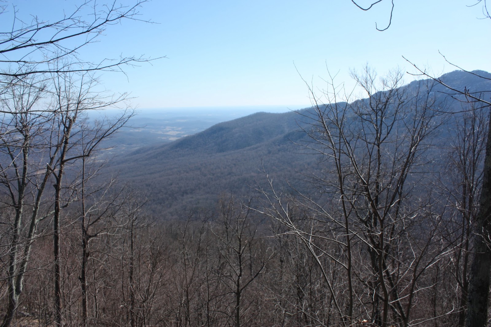
Elliott Knob is the high point of Great North Mountain. It is one of the highest peaks in this part of Virginia: it stands at 4463 feet as the highest mountain that directly abuts Shenandoah Valley. Hawksbill and Stony Man, the highest peaks in Shenandoah, are a full 400 feet shorter than Elliott Knob. From the South District of Shenandoah, Elliott Knob is ubiquitous: views from Furnace Mountain, Lewis Peak, Turk Mountain, Riprap, etc. all feature Elliott Knob towering over Shenandoah Valley. The prominence of this mountain drew me to hike it despite what I already knew to be the shortcomings about the trail.

I set out early on an April morning, with the sun rising as I drove west out of Charlottesville on I-64. The view was incredible as I passed Rockfish Gap. To the north, the early morning rays lit up Trayfoot and Turk Mountains, and the Blue Ridge was a vibrant, almost electric green. I continued west on I-64 until it merged into I-81 south; on I-81 south, the redbud was still in bloom. Immediately after getting on I-81, I took VA 262 west. I followed 262 into I got to VA 254 (Parkersburg Turnpike), which I took west. Coming off the ramp from 262 to 254, there was yet another incredible view- this time of the Ridge and Valley Appalachians stretching to the north.

VA 254 is a ridiculously beautiful country road that epitomizes everything about Shenandoah Valley. The road passed through 2 small hamlets before breaking out into the farmland of the Virginia countryside. Cows grazed in grass set blazing with color by the early sun, and in front of my windshield I could see the high, commanding pointy-top of Elliott Knob. VA 254 merged into VA 42, which I took west, at Buffalo Gap. VA 42 drove straight through the narrow water gap cut into Little North Mountain. About two miles past Buffalo Gap, I turned off at the trailhead. The trailhead is easy to miss: It is a gated forestry road with no parking area. To confirm that you're at the right place, get off at the forestry road and check to see if there's a trail sign that indicates "Elliott Knob 4 miles." I parked along the side of the road and then started my way up the trail.

The beginning of the trail is almost boring. The fire road ascends gently, with yellow blazes, and bends first to the right, and then to the left. A number of spur forestry roads run off to the right of the road, but the main road is pretty easy to follow. At about a mile in, the trail widens into a few clearings. A mile and a half from the trailhead, the road starts to narrow into a trail, which comes to and follows the left side of Falls Hollow Run.

The next section of trail- about a mile or so- is one of the most pleasant of the hike. The ascent is still gentle as the trail goes up Falls Hollow Run, passing many small cascades. The trail crosses the run fully twice, and once the trail crosses the run halfway by going onto an island in the run. The crossings were quite easy and could be done by rock-hop, but it's possible that they could be a little more challenging during periods of higher water.

Small waterfall on Falls Hollow Run
After crossing back to the left bank of the run, the gradient of the ascent steepens. The trail climbs high above Falls Hollow Run. Many more waterfalls are visible on the run through the trees, but getting to those falls would be a nasty bushwhack. The trail then flattens out and rejoins the run near the most impressive waterfall that I saw, which required a short bushwhack downhill. Small sandstone cliffs towered above the stream in this part of the hollow.

Waterfall in Falls Hollow
Just uphill of this waterfall, a small spur trail lead to this drop; it was difficult to see the full falls.

Upper waterfall in Falls Hollow
After passing the final falls in the hollow, the trail continued along the stream for another hundred meters before taking a sharp turn. This sharp turn is marked by three yellow diamonds on a tree. Be sure to turn here; the former trail continues but is blocked off with some brush. So when the going gets hard and you're struggling through a pile of brush, make sure you're still on the trail. The turn leads to a much narrower trail that cuts through forest and some mountain laurel as it heads south and east. There is minimal elevation gain until the end. In a little under a mile, the trail reaches the ridgeline of one of the flanks of Elliott Knob. Here, it ends at a gravel road in a powerline clearing.

From here to the top, the hike follows the gravel road. On the way back, a set of three yellow diamonds mark the spot where the trail intersects the road.

The road was tough. It's only a mile and a bit from the junction with the gravel road to the summit, but it took me nearly 35 minutes to get up it. The road ascends 1200 feet in a mile. The ascent was quite taxing, but at any point I was able to turn around and see a narrow view of Shenandoah Valley from the clearing around the road. As I climbed higher, the views improved.

Steep gravel road up Elliott Knob
After a rather tiring half hour of ascent, I finally came within sight of the transmission towers. At this point, I was close to the top; the road flattened out a little, I passed by a man-made pond on the right of the trail, and most importantly I entered a new climate zone. Whereas the lower slopes of the mountain were populated with the standard eastern hardwood mix, high up on Elliott Knob, above 4200 feet or so, were multiple stands of red spruce. Spruce survives in colder climates and is a rarity in Virginia.

Red spruce atop Elliott Knob
Past the first spruce stands, I continued the final climb. After passing by the junction for the North Mountain Trail, the road ended in a cul-de-sac at the top of the ridge next to the transmission towers. A less maintained, grassy road continued on the western side of the crest; I followed this road toward the top of the knob. Just a few yards up the road, I came to a rock ledge on the left side of the road. This ledge opened to an incredible view of the Calf Pasture River Valley and of Shenandoah Mountain.

View west to Shenandoah Mountain
On my way back, I took a nap on this rock. On my way up, I continued after taking some photos. A hundred yards or so further on, the grassy road flattened out onto the grassy summit of the knob, at 4463 feet. From the grassy area, there was a view to the east of the Blue Ridge; however, here, the views did not poke up much beyond the trees. Behind the grassy area were multiple spruce stands on the summit, and a fenced-off old fire lookout tower. It's illegal to trespass and ascend the lookout tower but I've heard the views are amazing.

Fire Tower atop Elliott Knob
I spent a while at the summit area enjoying the views of Shenandoah Valley, the Blue Ridge, and Buffalo Gap to the east, and of Shenandoah Mountain to the west and north. To the east, I could see Massanutten Mountain and all of the Blue Ridge from Hightop down to Maintop. I spent nearly two hours at the summit before heading down; over the course of the entire hike, I ran into only 2 people hiking and a horseback group on the initial forestry road on my way back.

Blue Ridge from Elliott Knob

Cat Rock

View from Cat Rock
2.6 miles round trip, 830 feet elevation gain

Cat Rock is a hike to a talus jumble of Antietam Sandstone with a limited but pleasant view in Cunningham Falls State Park. The hike is short but enjoyable, with a small rock scramble at the end.

I hiked Cat Rock on a weekend in early August with two good friends, during a time when the president was visiting Camp David. From the Rockville area, I took I-270 northwest to Frederick, then took US 15 north from Frederick to Thurmont. At Thurmont, I hopped onto Rout 77 west, which took me west into Catoctin Mountain Park. Route 77 is particularly pretty entering the park, as it winds into the mountains next to a small stream. I parked at a trailhead across the road from the Park Headquarters. This was the start of the hike, which headed south into Cunningham Falls State Park rather than north into Catoctin Mountain Park.

The trailhead information board at the start of the hike indicated that this was a "strenuous" hike, but I would certainly not consider that to be the case- compared to most hikes in SNP and farther south in the Blue Ridge, this is at most a moderately difficult hike. The trail swings to the east and south from the trailhead, climbing along the eastern side of Catoctin Mountain. It was a fairly gentle but persistent uphill following the yellow blazes. In a little under a mile from the trailhead, we passed a junction with a trail that led down to Hunting Creek Lake. Fungi sprouted all around the trail, a typical scene in the Appalachians in late summer.

Fungi along the Cat Rock Trail


After passing the trail junction, we passed through a powerline clearing along the trail. Continuing a little further on, a little over a mile from the trailhead, we came to a junction with the Bob's Hill Trail at what seemed to be the top of the ridge. From here, we followed the trail for Cat Rock, which descended slightly and headed east. This trail wound through the woods until dead-ending near the rock scramble. A final bit of uphill and a bit of rock scrambling brought us onto the top of the white rocks at Cat Rock. Cat Rock was really more a talus jumble than a single rock. Climbing along the highest ridge of rock in the center of the rock, we had a view of the ridgeline of Catoctin Mountain. To the north, a few more ridges of Catoctin Mountain were visible; in general the view was not too expansive. However, the rocks at the overlook still made a pleasant resting spot. Apparently Sugarloaf Mountain is visible from the rock on clear days; however, it was slightly hazy during our hike so our visibility was a little limited.

View east from Cat Rock

A helicopter flew overhead while we were at Cat Rock. Helicopters are fairly common to the area- Catoctin Mountain Park is home of Camp David, the president's mountain retreat. Franklin Roosevelt first established the presidential retreat here and named it Shangri-La; Hoover had earlier established Camp Rapidan in Shenandoah National Park, but Roosevelt's physical condition made getting to Catoctin Mountain much easier than getting high up the valley of the Rapidan. Later, President Eisenhower renamed Shangri-La after his grandson David.

Monday, May 6, 2013

Duncan Knob

View south from Duncan Knob
3.4 miles round trip, 1100 feet elevation gain

The short hike to the summit of Duncan Knob from the Gap Creek Trailhead affords a spectacular view for fairly little effort. Duncan Knob is one of the many summits of Massanutten Mountain, the long mountain that cuts Shenandoah Valley into two, so it affords good views of both the Blue Ridge Mountains to the east and Great North Mountain and the Alleghenies to the west.

I hiked Duncan Knob on a very early September morning. I had to return to Charlottesville by noon, so I woke up before the sunrise and drove north up Route 29 to Ruckersville, then west on Route 33 to Elkton across Swift Run Gap, then north along US 340. The scenery on US 340 was magnificent in the early morning: Massanutten Mountain rose above a layer of fog near Elkton, and the sun rose while I drove up Page Valley with the Blue Ridge on one side and Massanutten on the other. I turned right (west) at US 211 and followed it up to New Market Gap, and then took Crisman Hollow Rd, a poorly marked turn, at the top of the pass. It is easy to miss this road; just know to turn right once you reach the highest point along US 211. Crisman Hollow Road wound its way up the mountain, coming to a spectacular view of the sunrise before entering Fort Valley. I drove about 5 miles on Crisman Hollow Road to the Gap Creek Campground. The area is not well marked, but it is the pull-off to the right of the road about 2 miles after the Scothorn Gap Trailhead.

Sunrise on Massanutten Mountain

Finding the trailhead from the parking area was rather difficult. Gap Creek Campground has a short bumpy road that parallels Crisman Hollow Road with campsites on it: from the far (north) end of the campground, I hiked south into the campground road and found the trail heading back into the woods from the back of the second campsite in the area. Unfortunately, these campsites were not well maintained and in some cases had quite a bit of litter by them. To know that you're on the right trail, you'll see blue blazes and you'll cross a creek on a bridge right after leaving the campsite.

From the trailhead, the blue-blazed trail ascends through the fairly young woods. There are occasional signs of past human use and habitation along this trail. The ascent isn't terribly steep or long, but there aren't views to entertain; after a mile or so from the trailhead, the Gap Creek Trail intersects the Scothorn Gap Trail. From here, I continued on the blue-blazed trail, climbing along the south slope of Duncan Knob towards Peach Orchard Gap, which was occasionally visible through the trees. After about a mile and a half of hiking from the trailhead, I arrive at Peach Orchard Gap, where morning sunlight streamed through the trees.

Forest at Peach Orchard Gap

I headed left up the white-blazed Duncan Knob Trail from the gap. The Duncan Knob trail was a little overgrown, but was still fairly easy to follow as it ascended quickly through the woods. However, the trail got progressively rockier and eventually faded when I arrived at the rock scramble. Here, the trail disappeared at the foot of a huge sandstone talus slope. A few cairns marked the way but weren't terribly easy to follow; I ended up just picking my own route up the talus slope up, cutting towards the west (left) side of the peak. As I scrambled upward, amazing views of the Blue Ridge Mountains and Page Valley opened up behind me. At the end of the scramble, having lost the trail, I forced my way up a narrow chute of talus and arrived at the summit ridgeline. I walked out onto a sandstone ledge atop the peak and took in the huge view, which included everything from Hawksbill down through the South District of Shenandoah, Strickler Knob on Middle Mountain, Fort Valley, and Great North Mountain. I spent twenty minutes soaking in the views before I scrambled down the rocks again, found the trail after the rock scramble, and made my way back to Charlottesville to be on time for the rest of my day.

View into Fort Valley from Duncan Knob
I would encourage you to take note of where you come up onto the rock scramble if you do decide to hike Duncan Knob, as I imagine it'd be quite easy to get lost when trying to find the white-blazed trail on the way back down the mountain.

Some notes on geology: Duncan Knob is one of the easiest places to observe the difference in the physiographic regions of Virginia. To the east, it is possible to see the distinct summits and peaks of the Blue Ridge, while to the west it is possible to see the endless flat, parallel ridges that make the Ridge and Valley. It is also possible to see that Massanutten Mountain itself belongs to a similar Ridge and Valley structure as that found further west. Unlike the more complex folding of the Blue Ridge anticlinorium to the east, Massanutten Mountain is part of the Massanutten synclinorium, a less complex fold in which the top of the syncline has eroded, leaving the more resistant rock layers as the ridges that bound each side of Fort Valley.

Wednesday, May 1, 2013

Spy Rock

Devil's Knob, Three Ridges, and Trayfoot Mt. in the far, far distance
3 miles round trip, 1150 feet elevation gain
Difficulty: Easy-moderate, with a bit of rock scrambling at the end
Access: Paved road to trailhead, no entrance fee required

The 360-degree view from Spy Rock is one of the most remarkable in Virginia's Blue Ridge Mountains. Located on the flank of Maintop Mountain, the rock provides a stunning full panorama of the Blue Ridge south of Rockfish Gap. The rock is accessible via a short though at times steep hike with a brief rock scramble at the end. As of December 2020, the popular trailhead at Montebello Fish Hatchery is closing, which may make it necessary to reach this trailhead from the Crabtree Meadows Trailhead (or the Crabtree Falls Trail for those without a 4WD) in the future via a much longer hike.

I did this hike on a crisp early October morning with a friend. We left Charlottesville just before sunrise for the 90-minute drive to Montebello. I took I-64 west and then took exit 107 to US 250 west to VA 151. The sun rose as we drove through Rockfish Valley, with early morning fall light hitting Humpback and Devil's Knob as we passed by spectacular roadside maples. After crossing a gap through some of the Blue Ridge foothills south of Nellysford, we came to VA 56, which we took west (right). VA 56 followed the Tye River past Massie's Mill, with spectacular views of the Priest and Three Ridges. The road narrowed as we ascended into the mountains, passing Crabtree Falls and the turnoff for Meadows Rd. before we finally came to the Montebello Fish Hatchery on the south (from our direction, left) side of the road. We turned into the Fish Hatchery and followed signs for the trailhead to reach the trailhead for Spy Rock, which was a small, fenced-off parking area adjacent to a grassy field.

Two gravel roads headed into the mountains from the trailhead. The trail follows the gravel road to the right (not the one that seems to be a continuation of the road that you drove in on to the trailhead). The first mile of the hike follows this gravel road, which ascends, sometimes steeply, through hardwood forest. This part of the hike would likely be nondescript for much of the year, but during fall, the entire forest was brightly lit up with color. Along the way, another gravel road branches off from the main gravel road; follow the branch that continues uphill.

Fall foliage on the gravel road
After a mile of ascent from the trailhead, the gravel road reaches a saddle on Maintop Mountain. From here, we took the Appalachian Trail north (left). The AT began a steady climb up Maintop Mountain, passing a small gate. The trail began by following the crest but soon swung to south of the ridgeline. We continued on this section of the AT for a half mile (a little over 10 minutes) before spotting Spy Rock through the trees. A little after first spotting it off to our right, we came to a saddle with a few cleared campsites.

Forest along the Appalachian Trail
Here, we split from the AT and hiked along the saddle towards the base of Spy Rock. The last section of the hike was a fun rock scramble. Spy Rock is a large chunk of exposed granite that pops out from the ridge, so getting to the top required a fun scramble upward. This rock scramble may be challenging to those not accustomed to rock scrambling- it was a step above Bearfence Mountain in Shenandoah but certainly much easier than Old Rag. Towards the end of the scramble, the rock began to flatten out and views to the west opened up. At the top of the rock, we found incredible 360-degree views. The most immediately striking part of the vista was to the south: Spy Rock towered over the valley of the Piney River. Across the valley were the Friar, the Cardinal, and Mt. Pleasant. To the west were Rocky Mountain and Elk Pond Mountain and the Blue Ridge Parkway, and a view through a gap to Shenandoah Valley. Close by to the north was Maintop Mountain. Far to the north, there was a beautiful view of distant Trayfoot Mountain rising out of the Valley, and more close by the peaks of Devil's Knob and Three Ridges. To the east was the many humps of the Priest and the color-saturated fall forests of the Piedmont.

The Priest from Spy Rock

Maintop Mountain and Shenandoah Valley
While the view into the Piney River watershed from the top was brilliant, I found an even better viewpoint to the south on the south side of the rock. Here, a faint trail leads off the rock steeply downhill. The path cuts through the trees for a hundred yards or so and then emerges on a broad, open slab of granite. The view from this outcrop was much more open to the south: I could see a farm in the valley below and all the peaks that I had seen from atop the rock.

View of the Cardinal and Mt. Pleasant from the lower outcrop on Spy Rock
This hike has become one of my favorites in the state: the view from atop the rock is truly stunning. The peaks encompassed in the vista include most of the highest peaks in this part of the Blue Ridge (The Priest, Three Ridges, Maintop, Mt. Pleasant, Elk Pond, and Rocky). The trail itself, while not as spectacular as the end view, is also fun and enjoyable.

View to the south
View to the north