Wednesday, June 29, 2022

Paradise Peak and Atwell Grove

Castle Rocks and the Middle Fork Kaweah River Valley
9.5 miles round trip, 3000 feet elevation gain
Difficulty: Moderate, slight route-finding skills necessary
Access: Rough, narrow, windy road to trailhead, Sequoia National Park entrance fee required

One of the more overlooked trails in the already-quieter Mineral King area of California’s Sequoia National Park, the Paradise Ridge Trail climbs through a stately and calm grove of giant sequoias before a spur trail continues on to a mid-elevation summit with great views of both the Sierra foothills and the Great Western Divide. Atwell Grove is perhaps the highlight of this hike: the trail only grazes the edges of this sprawling forest of giant sequoias but hikers are treated to some lovely and impressive trees, including some of the highest elevation sequoias out there. The Paradise Peak Trail, a 1.5 mile spur off the Paradise Ridge Trail, is unmarked and covered with many downed trees but is actually fairly straightforward to follow and is a worthy final destination for this enjoyable and beautiful if not superlative hike.

Sequoia National Park, including areas around Mineral King, were devastated by the KNP Complex Fire in the autumn of 2021- one of the two blazes comprising this complex, the Paradise Fire, was actually sparked on the slopes of Paradise Peak. The area around the Paradise Ridge Trail and along the spur trail to the peak appear to have miraculously managed to escape major fire damage in the KNP Complex Fire, so this hike will hopefully reopen soon.

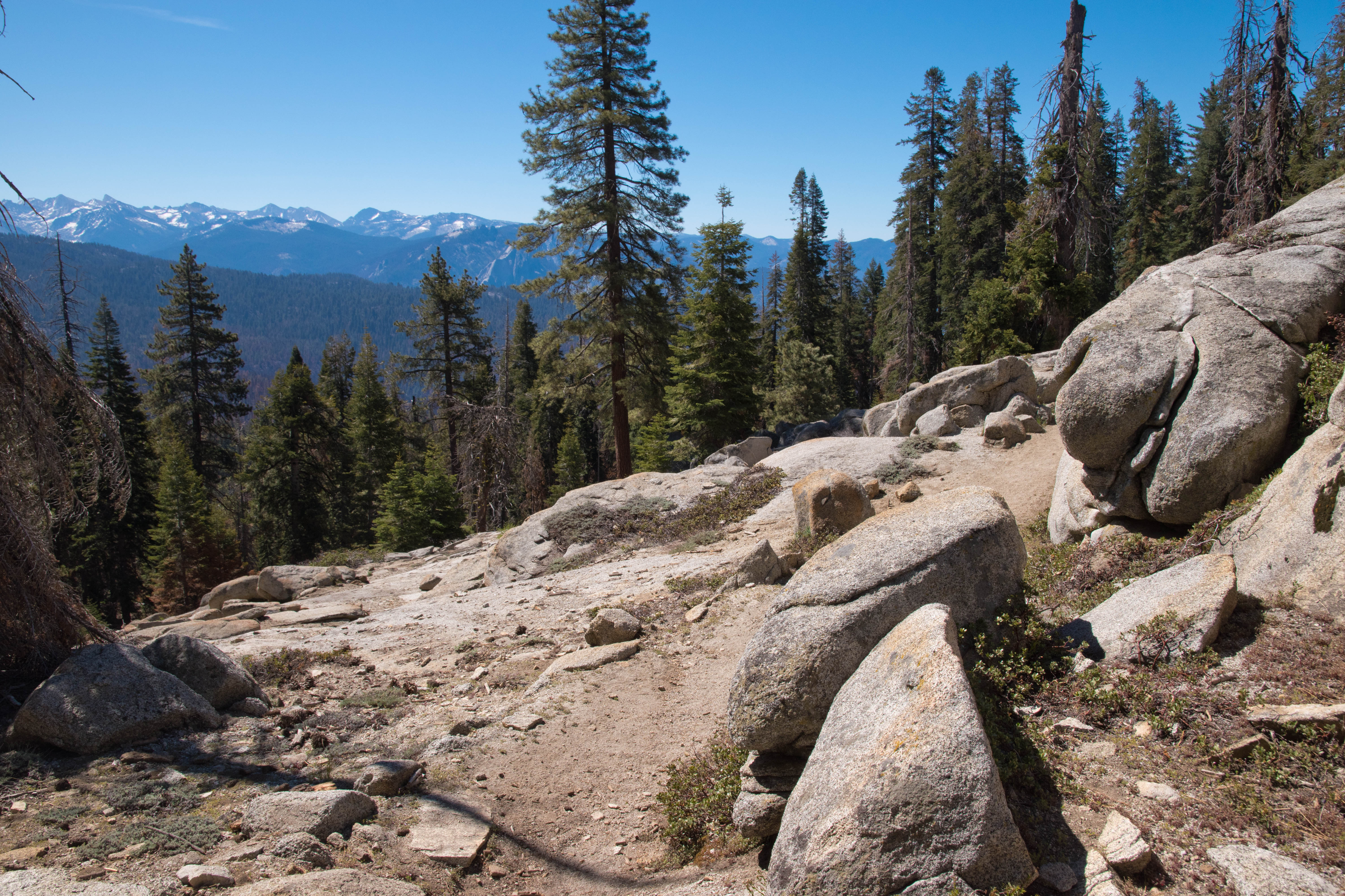
Mineral King Valley is more than four hours driving from either the Bay Area or the Los Angeles area, so it requires at least a full weekend commitment for most people. To reach Mineral King, I left Highway 99 in the Central Valley at exit 97 for Highway 198, which I followed east past Visalia and Three Rivers. About five miles after passing the Village Market/Pizza Factory area in Three Rivers, I made a right turn onto the Mineral King Road. I followed Mineral King Road for the next ___ miles, entering Sequoia National Park. Mineral King Road is infamous for its windiness: the road makes over 400 curves on its way up from Three Rivers into the valley of the East Fork Kaweah River. There are no lane divides along most of this road and in some areas it’s wide enough for only a single car; as the road climbs through incredibly steep terrain, there are frequently sheer drop-offs to the south side of the road. The road is paved through the Atwell Mill area and Paradise Ridge trailhead but was bumpy at times with some sizeable potholes.

At mile 19 of the Mineral King Road, I passed a trailhead sign for the Paradise Ridge Trail. The Paradise Ridge Trail left from the left (north) side of the road here, but there is no parking at the true trailhead; instead, I had to drive onwards for another quarter mile, passing the entrance to the Atwell Mill campground and then pulling into a medium-sized gravel lot to the right of the Mineral King Road at the upper end of the campground that was signed for hiker parking. There’s enough room here for perhaps 20 cars; this is the trailhead not only for the Paradise Ridge Trail, but also the Atwell-Hockett Trail that accesses the Atwell Plateau. On the Saturday of Labor Day weekend, my car was the first in the lot around 9:30 AM.

To reach the trailhead from the parking area, I followed a gravel road west from the parking lot through the Atwell Mill Campground; at the western end of the campground, I followed the Mineral King Road itself through 2 curves for about a hundred meters to reach the Paradise Ridge Trail. I crossed the road and started up this trail, which immediately embarked on a steady ascent through the forest. The forest was initially nondescript until about 2/3 of a mile, when the trail entered a burned part of Atwell Grove that had a handful of smaller sequoias with fire-scarred trunks. The trees were still quite tall but lacked the immense girth that characterize true old-growth giants. Departing this grove, the trail crossed an open, brushy slope from which I had good views of the mountains across the valley, with the rocky granite ridge leading towards Hengst Peak.

At one mile from the trailhead, the Paradise Ridge Trail turned a corner where brushy chaparral very suddenly transitioned to the impressive giant sequoias of Atwell Grove. The most scenic part of the grove came near where the trail crossed a stream: here, the wetter environs supported a greener understory and there was a higher density of sequoias. The trail ascended a bit and then doubled back into the grove at a higher elevation, passing another handful of nice sequoias.

Sequoias of Atwell Grove
Atwell Grove
Massive sequoia in Atwell Grove
At about 1.4 miles, the trail exited the grove and broke back out onto the open, brushy slope, once again delivering nice views of the East Fork Kaweah Valley and the broccoli-top sequoias deeper within Atwell Grove that lined the ridge to the west.

Looking down the East Fork Kaweah River Valley
After more, steady ascent through forest, the trail reentered Atwell Grove at 2 miles. The entrance to this section of the grove was announced by an absolutely massive sequoia just downslope of the trail that had been partially burned out by fire on its trail-facing side. This upper grove was pretty, especially at first, but lacked the lushness and majesty of the lower section of the grove.

Upper part of Atwell Grove
The trail ascended through this grove with a few switchbacks and then swung east and left this grove, as well. Over most of the next mile, the trail stayed in a nondescript forest as it climbed steadily uphill towards Paradise Ridge. Shortly before reaching the ridge, the trail broke back out into the open for some more views of rocky Hengst Peak across the valley.

View of Hengst Peak near Paradise Ridge
The trail made a final short switchback and then at just under three miles from the trailhead, I arrived at a saddle on the crest of forested Paradise Ridge. There were no views from the top of the ridge, just trees; a trail sign here indicated that the Paradise Ridge Trail would continue for another 6 miles to Redwood Meadow Grove, a remote, backcountry grove of giant sequoias in the Middle Fork Kaweah watershed.

There was no sign pointing out the route to Paradise Peak here, but it’s fairly straightforward to find the way here. The path- which in the past was a maintained trail- headed left (west) along the top of the ridge and initially required negotiating a significant amount of tree deadfall. After a stretch of flatter hiking along the ridge, the path began to ascend, sometimes steeply, along the spine of the ridge. I passed a couple outcrops that were fifty or so meters off the trail that had some decent views of Mineral King Valley and the Great Western Divide but I continued on to catch the better views at higher elevations.

Deadfall-covered trail towards Paradise Peak
I lost the trail multiple times on my way up the ridge towards Paradise Peak as the path is no longer maintained and the route required navigating past many, many fallen trees that obscured the path. The trail climbed steadily for the most part with a few steep inclines and stayed in the forest for almost the entire time. Halfway through the ascent- about 0.7 miles after leaving the Paradise Ridge Trail- the path swung by a small clearing that had a very pretty view to the east of the Great Western Divide, including Sawtooth Peak and Florence Peak. Even more notable was the broccoli top of a giant sequoia visible just below us: at 8800 feet above sea level, this old growth giant sequoia lies at the very top of Atwell Grove and forms the upper elevation limit of the giant sequoia’s range.

Great Western Divide and a high elevation old-growth sequoia
I continued uphill, negotiating more deadfall as I went; the trail faded as I approached the summit, but the ridge was well defined so this wasn’t a major issue. When I reached the true 9362-foot summit of Paradise Peak, trees lined the summit and the rocks here only provided a partial view north of the Castle Rocks, Moro Rock, the Middle Fork Kaweah Canyon, and the granite domes of Big and Little Baldies. 

Castle Rock, Moro Rock, Big and Little Baldies
I stopped to enjoy the view for a moment, but then I continued just a little further west along the ridge, descending slightly to come of the base of a massive west-facing granite outcrop. I had to do a bit of rock scrambling to reach the top of this outcrop, which hosted some transmission equipment but more importantly had astounding, airy views to the north and west.

From this enormous outcrop, I had a stunning view down into the Middle Fork Kaweah Valley. Moro Rock rose imposingly across the valley, its shoulders draped with the broccoli tops of the sequoias of Giant Forest. I could see the back side of Castle Rocks from here, although the magnificent granite cliffs of its north face were hidden from view. I could even see all the way to the gray, barren granite of Alta Peak.

Sierra foothills- the KNP Complex Fire ignited here five days after this photo
Writing this post, I feel a certain sense of loss: a mere five days after I stood atop Paradise Peak, lightning struck the lower slopes of the mountain and ignited the KNP Complex Fire, which engulfed most of Paradise Peak in flames over the course of the next month, although miraculously, just about every part of the Paradise Ridge Trail and Paradise Peak itself were spared. However, the lower slopes of Paradise Peak and many of the area’s sequoia groves did not fare so well: Castle Creek Grove on nearby Castle Rocks may have been completely incinerated and Redwood Mountain Grove in Kings Canyon National Park suffered extreme fire damage.

Atwell Grove's close call with the KNP Complex Fire is a reminder of how vulnerable and precious these giant sequoias are in the time of climate change. Hikers should come soon to see these sequoias, as the KNP Complex Fire, Castle Fire, and Windy Fire in 2020 and 2021 devastated nearly the full range of the species. This hike may not have the high alpine draw of other Mineral King destinations but is still a lovely place for enjoyable Sierra views coupled with a stunning grove of sequoias.

Wednesday, June 22, 2022

Alta Peak

Great Western Divide from Alta Peak
14 miles round trip, 4000 feet elevation gain
Difficulty: Strenuous
Access: Paved road to trailhead, Sequoia-Kings Canyon National Park entrance fee required

As the only High Sierra peak accessible on a day hike by a maintained trail within California’s Sequoia National Park (besides Mount Whitney), Alta Peak delivers the sweeping panoramas you’d expect of a peak of its name. This lofty summit is accessible by a long and tough day hike from the edge of the Giant Forest area and offers the sort of High Sierra views generally only reserved for serious backpackers. The route to reach the summit is long but scenic and makes this one of the premiere day hikes of Sequoia National Park. The peak’s 11208-foot height may be enough to induce altitude sickness for some hikers, so pay attention to your body’s signals as you hike.

The 7-mile distance from the trailhead at Wolverton to Alta Peak can be broken down into four legs: an initial two-mile stretch along the Lakes Trail, an ensuing one mile stretch along the Panther Gap Trail to reach Panther Gap, a flatter two-mile segment on southern slopes of Alta Peak, and the final steep climb to the summit over the last two miles.

I hiked Alta Peak on a mid-May weekend during a year when a meager winter snowpack and early snowmelt made the hike possible about one to two months earlier than usual. The hike started from the Wolverton Trailhead in Sequoia National Park, which can be accessed from the Central Valley by either taking Highway 180 into Kings Canyon National Park or Highway 198 into Sequoia National Park. Both routes require taking Generals Highway to the stretch between Giant Forest and Lodgepole; the turnoff for Wolverton is well marked and heads east from Generals Highway. I followed Wolverton Road for about two miles to its end, passing the turnoff for the General Sherman Tree parking area along the way. There is a long parking lot with room for well over a hundred cars at the end of the Wolverton Road; the hike to Alta Peak starts from the segment of the parking lot just to the left of the entrance to the lot.

Leaving the Wolverton Trailhead, I started out by following the Lakes Trail north from the parking lot. The trail climbed briefly and in a hundred meters reached the crest of a ridge; here, the trail turned towards the right and began following the ridge to the east. The trail climbed steadily over the next 2/3 of a mile as it ascended along this forested ridge, passing patches of spring wildflowers. There were occasional peeks of rocky Mount Silliman rising on the other side of Tokopah Valley through the trees, but otherwise there were no real views to speak of in the opening stretch of the hike.

At a mile into the hike, the trail leveled out for a stretch and soon left the top of the ridge, instead passing through forested mountain slopes above Wolverton Creek while again ascending steadily. The forest gave way to some grassy and brushy clearings as the trail crossed a small creek; wildflowers were blooming quite nicely here in the spring, and I’ve spotted a bear in this area before. Just under 2 miles from the trailhead, I came to a fork in the trail: the Lakes Trail continued to the left while the Panther Gap Trail headed to the right.

Lodgepole pines on the Lakes Trail
I turned right at the junction to take the trail towards Panther Gap and Alta Peak. The trail continued climbing steadily, traveling mostly through the forest but occasionally passing through grassy clearings as it crossed multiple streams. After a mile of steady uphill ascent through the forest after leaving the Lakes Trail, I came to Panther Gap at just under 3 miles into the hike, arriving at the junction with the Alta Trail.

Panther Gap delivered the first views of the hike. While the north side of the saddle was forested, the south side was open, delivering a view across the Middle Fork Kaweah Valley to Castle Rocks. A portion of the Great Western Divide also featured to the left side of this view, including Sawtooth Peak and Vandever Mountain, two distinctive summits rising above Mineral King Valley. The Alta Trail split in two directions from Panther Gap, following the ridge both ways: the right fork led down to Giant Forest, while the left fork headed east towards Alta Peak. I took the left fork, which ascended for a bit along the ridge before heading out onto the exposed south slopes halfway up Alta Peak.

View of the Castle Rocks and the Great Western Divide from Panther Gap
The next mile to the junction with the High Sierra Cutoff Trail featured absolutely spectacular scenery, with the Great Western Divide’s snowy and rocky peaks unfurled majestically to the east. To the west, views extended past Castle Rocks into the dusty Sierra foothills. Rock formations near the trail were frequently quite interesting here: my favorite was a rock that had the profile of a standing bear.

View towards Castle Rocks and the foothills from the Alta Trail above Panther Gap
At 4 miles, the Alta Trail came to a junction with the High Sierra Cutoff Trail; while the High Sierra Cutoff Trail headed downhill and to the right to join the High Sierra Trail, I went straight through the junction to stay on the Alta Trail. The open views ended shortly afterwards, with the Alta Trail reentering a forest of stately lodgepole pines. The Alta Trail reached Mehrten Meadow, a popular campsite, not long after the High Sierra Cutoff junction, at 4.2 miles; a nice stream flowed next to the meadow but the meadow itself was quite underwhelming, just a small, sloping patch of grass in the forest.

Mehrten Meadow
The Alta Trail continued traveling through the forest, ascending gradually, until I came to the junction with the Alta Peak Trail at 5 miles from the trailhead. At this junction, the right fork led to Alta Meadow, an alpine meadow below the peak, while the left fork led up to Alta Peak’s high summit. Taking the left fork, I embarked on the final two miles of the climb, the steepest, highest elevation, and thus most strenuous stretch of the hike: with just two miles left, the trail climbed 2000 feet, packing in half of the hike’s elevation gain.

Leaving the junction with the Alta Trail, the Alta Peak Trail was initially somewhat open, with views of the Tharps Rock, a false summit of Alta Peak, rising directly above me. After a few hundred meters of hiking with some views of Alta Peak’s dramatic upper reaches rising above, the trail reentered the forest as it ascended persistently. The trail stuck to the forest for the next mile, although after rounding a corner on the ridge at 5.5 miles from the trailhead, occasional breaks in the trees provided astonishing and open views of the snowy granite peaks of the Great Western Divide.

Tharp's Rock
As the trail entered an alpine environment, flora and fauna of the highest elevations began to show up. I spotted a yellow-bellied marmot staring curiously at me: this cousin of the groundhog is common in subalpine and alpine terrain throughout the Sierra Nevada. Pasqueflower- a pretty, early-blooming flower that transitions to a fuzzy seed head later in summer- bloomed close to the ground.

Marmot
Pasqueflower blooming
At 6 miles from the trailhead, the Alta Peak Trail made a sharp switchback; from here, there were magnificent views of the Great Western Divide rising above Alta Meadow in the foreground. As the trail reversed direction, it continued to climb aggressively up Alta Peak, with the lodgepole pines of the mid-elevations transitioning to the foxtail pines that appear just below the timberline. Foxtail pines are a close relative of the better known bristlecone pines that dot the Great Basin and live longer than any other tree; foxtail pines have similar wizened appearances to their cousins and also thrive in high altitude environments where other plants cannot survive, but they do not live nearly as long as their nearly 5000 year old cousins, with the oldest reported foxtail pines not even reaching half that number. These stout, windswept trees were the last arboreal outposts on Alta Peak before barren granite dominated the remainder of the peak’s height.

Foxtail pines and the Great Western Divide
At 6.3 miles from the trailhead, the Alta Peak Trail approached Tharps Rock, a massive granite outcropping that jutted out to the south from the main body of Alta Peak. Views from near the rock extended down into the Middle Fork Kaweah Valley and the Central Valley. Tharps Rock is named after Hale Tharp, a Gold Rush-era arrival in California who became the first documented European American to settle in Giant Forest. Tharp lived for a while in the hollowed-out trunk of a fallen sequoia, which today is still preserved as Tharps Log at Log Meadow in Giant Forest.

Tharp's Rock
Leaving Tharps Rock, the trail continued its final steep ascent, barreling up a shallow granite chute that was dotted with the last of the foxtail pines. The aggressive uphill grade and the high altitude combined to make this part of the hike the most challenging stretch of this otherwise-straightforward trail. The summit was now visible, rising at the top of the granite chute. A constant push up this trail finally brought me to the edge of the northern cliffs of Alta Peak, just short of the actual summit.

Foxtail pines on Alta Peak
From these massive cliffs above the north face of the mountain, I had a terrific view of the Lakes Basin below me, with Aster and Emerald Lake visible in one basin and Pear Lake in a separate basin of polished granite. Twin-summited Mount Silliman rose across the valley.

Aster, Emerald, and Pear Lakes with Mount Silliman
After briefly skirting the rim of Alta Peak’s north face, the trail ended at the base of the rocky summit block. A bit of scrambling brought me to the very top of Alta Peak, 11208 feet above sea level. There was not much space to spread out here, as the summit is angled to one side with cliffs off the other side, so on a busier day you might want to enjoy your lunch from the many viewpoints below the summit. However, you’ll want to at least spend some time checking out the view up here, as that view is nothing short of incredible.

From the top of Alta Peak, I had an expansive panorama encompassing not only the portion of the Great Western Divide that I had seen on the hike up, but the barren granite landscape of the Tablelands to the north and east and the rugged peaks of Kings Canyon National Park in the distance. Most remarkable was the high ridge that made up the northern end of the Great Western Divide, which included the craggy forms of Table Mountain, North and South Guard Peaks, and Mount Brewer. Behind the Tablelands I could see the Monarch Divide rising above Kings Canyon, with North Palisade rising even further in the distance. At the other end of the Great Western Divide, I could see all of the high peaks around the Mineral King valley, as well as the distinctive dip of Farewell Gap east of Vandever Peak. In between, Mount Stewart, Eagle Scout Peak, and Mount Eisen were among the most prominent of the peaks here, while the colorful Kaweah Peaks rising in the background provided a strong contrast with what was otherwise a sea of gray rock. Through a gap in the Great Western Divide rose distant Mount Whitney, the tallest peak in the 48 states.

Great Western Divide and Mineral King peaks
Great Western Divide and Mount Whitney
Mount Brewer and Table Mountain at the northern end of the Great Western Divide
To the west, I could see down to Aster Lake, with Big Baldy, Little Baldy, Moro Rock, and Castle Rocks among the many granite domes dotting the otherwise forested landscape. On this clear spring day, I could see even beyond those peaks and past the foothills into the Central Valley, with the Temblor and Caliente Ranges visible far into the distance in the California Coast Ranges.

This is surely the most superlative view accessible by day hike on a maintained trail in the western slopes of the Sierra Nevada. I spent a good amount of time savoring the view at the summit, although I was not alone: at least thirty other people were in the vicinity of the summit during the time I was at or near the top, as the amazing views make this is a somewhat popular hike despite its length, altitude, and difficulty. While less popular than the Lakes Trail that departs from the same trailhead, you should still expect plenty of company on the way to Alta Peak. It’s absolutely worth it for the views, though. No serious California hiker should miss the panoramas from Alta Peak.

Wednesday, June 15, 2022

The Lakes Trail (Sequoia NP)

Alta Peak rises above the granite bowl of Pear Lake
12.5 miles round trip, 2800 feet elevation gain
Difficulty: Moderate
Access: Paved road to trailhead, Sequoia-Kings Canyon National Park entrance fee required

The Lakes Trail in California’s Sequoia National Park certainly lives up to its name: over its six-mile journey from Wolverton Trailhead, the hike visits four High Sierra alpine lakes, each more beautiful than the last, until culminating in the exquisite polished-granite scenery of Pear Lake. En route, the trail delivers great views of the cascading waters and granite walls of Tokopah Valley, with a thrilling stretch of trail cut into the cliffs near a soaring granite spire known as the Watchtower. Although by no means an easy hike, most visitors to Sequoia National Park may find this slightly long but very doable day hike to be the easiest way to access the park’s famed but notoriously hard-to-reach High Sierra backcountry. That makes the Lakes Trail an extremely popular hike- so expect to share the trail with hundreds of fellow hikers on nice summer weekends.

Around 2 miles in, the Lakes Trail splits into the Watchtower Trail and the Hump Trail; the Hump Trail is typically open for travel all year while the Watchtower Trail is closed through winter until snow and ice melt out on the route in late spring or early summer. I’ll describe a route to the lakes that takes the Watchtower Trail both on the outbound and return legs of the hike, as the Watchtower Trail is far more scenic; but early season hikers may find that they will need to the Hump Trail instead, adding some elevation gain (but no additional distance) to this hike.

I hiked the Lakes Trail to Pear Lake on a June weekend during a year with lower than normal Sierra Nevada snowpack. The hike started from the Wolverton Trailhead in Sequoia National Park, which can be accessed from the Central Valley by either taking Highway 180 into Kings Canyon National Park or Highway 198 into Sequoia National Park. Both routes require taking Generals Highway to the stretch between Giant Forest and Lodgepole; the turnoff for Wolverton is well marked and heads east from Generals Highway. I followed Wolverton Road for about two miles to its end, passing the turnoff for the General Sherman Tree parking area along the way. There is a long parking lot with room for well over a hundred cars at the end of the Wolverton Road; the Lakes Trail starts from the segment of the parking lot just to the left of the entrance to the lot.

Leaving the Wolverton Trailhead, I started out by following the Lakes Trail north from the parking lot. The trail climbed briefly and in a hundred meters reached the crest of a ridge; here, the trail turned towards the right and began following the ridge to the east. The trail climbed steadily over the next 2/3 of a mile as it ascended along this forested ridge, passing patches of early summer wildflowers that provided the main interest in this opening stretch of the hike. There were occasional peeks of rocky Mount Silliman rising on the other side of Tokopah Valley through the trees, but otherwise there were no real views to speak of.

Wildflowers on the trail
Early summer wildflowers
At a mile into the hike, the trail leveled out for a stretch and soon left the top of the ridge, instead passing through forested mountain slopes above Wolverton Creek while again ascending steadily. The forest gave way to some grassy and brushy clearings as the trail crossed a small creek; while passing through the clearing, I heard some rustling in the bushes downhill from the trail and realized I was standing perhaps just 50 feet from a black bear! We locked eyes for a moment, before the bear, seemingly annoyed that I had disrupted his meal, lumbered off a little farther downhill to continue nibbling on the vegetation, still within eyesight.

Out of focus bear amongst the aspens
At 1.8 miles from the trailhead, I came to a fork in the trail: the Lakes Trail continued to the left while the Panther Gap Trail headed to the right. I continued on the Lakes Trail, taking the left fork, which began a more aggressive climb through the forest. At 2.1 miles from the trailhead, I came to another fork in the trail, where the Lakes Trail split into the Watchtower and the Hump Trails. Both of these trails lead to Heather Lake and beyond; however, the Watchtower Trail is far more scenic and has less elevation gain so it is the preferred route despite being slightly longer. Early in the summer, before snow has melted sufficiently, the Watchtower Trail may be closed and it may be necessary to take the Hump Trail instead. Hikers with a fear of heights may also prefer the Hump Trail, as it skips over the cliff-edge route of the Watchtower Trail.

Lakes Trail winding through the pines
The Watchtower Trail marked the start of the spectacular scenery that characterizes the latter half of this hike. After initially following the Watchtower Trail for 1.1 miles through the forest, ascending steadily from the junction with the Hump Trail, the trail very suddenly broke out of the forest at 3.2 miles from the trailhead, coming to the south rim of Tokopah Valley right next to the Watchtower, a massive granite battlement that rose imperiously above the canyon below. Mount Silliman’s granite massif lay across Tokopah Valley, with Tokopah Falls- a continuous cascade plunging some 1200 feet over the course of half a mile- lay far below at the bottom of the valley. Granite peaks of the Tableland rose to the east.

Tokopah Valley from the Watchtower Overlook
Tokopah Falls
The Watchtower
Leaving the initial viewpoint, the Watchtower Trail generally stayed out in the open over the next 0.8 miles, at one point hugging the walls of Tokopah Valley on a trail blasted into the granite cliffs. The views here were airy and breathtaking: whenever I looked over the edge, I could see the granite walls of the canyon plunging to meet the cascading waters of Tokopah Falls. At 3.8 miles from the trailhead, the Watchtower Trail rounded a corner and turned right, leaving its perch above Tokopah Valley and heading in towards the basin that nestled Heather Lake. The Watchtower Trail joined back up with the Hump Trail at 4.1 miles from the trailhead (hikers taking the Hump Trail will be 3.7 miles from the trailhead but will have to add an additional 250 feet of elevation gain to this hike for the round trip).

Trail cut into the granite walls of Tokopah Valley
Shortly after the two trails rejoined, the Lakes Trail arrived at Heather Lake, now 4 miles from the trailhead. The main trail stayed north of the lakeshore except for briefly accessing the lake at the lake’s outlet; for the best views, I followed a spur trail to the lake that broke off shortly before reaching the outlet. Heather Lake was idyllic and pretty, ringed with trees and with a granite cliff rising behind it; ultimately, it was also the most pedestrian of the lakes. While hikers looking for a shorter outing might want to visit Heather Lake and then head back, I strongly encourage hikers who have the time and energy to continue out to Pear Lake if they’ve already come out this far.

Heather Lake
Leaving Heather Lake, the trail climbed slightly and contoured around a low ridge separating Heather Lake from the Emerald and Aster Lake watershed. Entering the Emerald Lake basin, the scenery was already more spectacular than at Heather Lake: the jagged cliffs of Alta Peak rose at the head of the basin.

The trail descended slightly as it entered Emerald Lake’s basin and came to a junction at 5.1 miles. Here, a spur trail split to the right of the trail, leading 150 meters slightly uphill and crossing the outlet stream of Emerald Lake to reach the shores of Emerald Lake itself. Emerald Lake is perhaps the quietest of the three main lakes, with fewer visitors than the constant flow of visitors who make it to Heather Lake but also fewer than Pear Lake as most hikers coming this far make a beeline for the end of the trail. However, despite its relative quiet, Emerald Lake is a gorgeous spot: granite outcrops by the shoreline provided a perfect spot for me to enjoy views of this gem of a lake with a backdrop of Alta Peak’s granite ramparts.

Emerald Lake
Continuing on the Lakes Trail from the Emerald Lake spur, I passed through a meadow with some nice views of Alta Peak to the back before entering a landscape of barren granite. The mountains were extremely bright at midday, with the pinks and the greys of the granite reflecting the harsh sunlight from all directions. As the trail contoured around the base of another ridge, I had outstanding views of Aster Lake nestled in the basin below the trail, with the twin granite peaks of Mount Silliman rising across Tokopah Valley.

Mount Silliman rising over Aster Lake
Ridges of Alta Peak rising above meadow near Emerald Lake
As the trail ascended gently and wrapped around the granite slopes, better views unfurled all around. To the west, the Watchtower came back into view, its peak now appearing more sharp and pronounced as it towered over Tokopah Valley. Big Baldy, a granite dome in neighboring Kings Canyon National Park, popped out as well. To the east and north, I had my closest look at the Tableland, a high plateau of barren granite that lies to the northeast of Alta Peak. At 5.8 miles, I passed a junction with a trail descending to the Pear Lake Ranger Station, which is actually a backcountry ski hut for hardy winter visitors. The broader views evaporated as I entered the basin containing Pear Lake, but I still had memorable views over Pear Lake’s outlet stream cascading down bare granite ledges to meet the Marble Fork Kaweah River. Alta Peak rose ahead, towering above the basin with foxtail pines dotting the attendant ridges. Finally, at 6.3 miles, the Lakes Trail ended at the northwest shore of Pear Lake. There was plenty of room for hikers who made it this far to spread out and enjoy the view.

Looking out to the Watchtower and Big Baldy
The bare granite of the Tableland
Pear Lake was the crown jewel of this hike, with beauty that affirms its status as a true High Sierra alpine lake. The lake is set in a granite bowl at the base of Alta Peak’s rocky crest, with foxtail pines dotting the basin around the lake. Pear Lake’s hourglass shape- which prompted earlier visitors to name it after a similarly shaped fruit- made the lake particularly attractive. A few patches of snow still dotted Alta Peak but the mountain’s snowpack was worryingly low considering my early June visit, an early portent of the dry conditions that year that would later spark the KNP Complex Fire which devastated Sequoia National Park.

Alta Peak rises over Pear Lake
Pear Lake is a popular camping destination, so there are bear boxes and a vault toilet on the northwest shore of the lake. It’s possible to venture along the east shore of the lake from the campsites and explore open granite slopes that run down to the lake: it’s much quieter here with equally good views. I found nice views from further along the shore of Mount Silliman rising above Pear Lake.

Mount Silliman rises above Pear Lake
Although this hike is somewhat longer and moderately difficult, it is still a very popular hike, as it provides the easiest access to the High Sierra in Sequoia National Park. Thus, I saw many hikers over the course of the day, with probably over 20 hikers at Pear Lake during my time there and over a hundred hikers on the trail over the course of the day. Despite the hike’s popularity, the fine scenery along this trail recommends this hike in Sequoia National Park as one of the better day hikes accessible by a paved road from the western slope of the Sierra Nevada.

Wednesday, June 8, 2022

Little Baldy (Sequoia-Kings Canyon)

Mount Eisen and Sawtooth Peak from Little Baldy
3.5 miles round trip, 800 feet elevation gain
Difficulty: Easy-moderate
Access: Paved road to trailhead, Sequoia National Park entrance fee required

While overcrowded Moro Rock gets the most love of the granite domes of California’s Sequoia National Park, the much higher granite dome of Little Baldy provides nearly equal views of the snowy Sierra Nevada with just a fraction of the tourist hordes that crowd Moro Rock and nearby Giant Forest. Seeing the majestic granite wall of the Great Western Divide is a key visitor experience at Sequoia National Park and almost all visitors get their fix on the narrow rock staircase of Moro Rock. Little Baldy offers a comparable view on a slightly longer but eminently enjoyable hike- it’s a worthy and recommendable hike for casual visitors who want to experience the park’s alpine beauty with a bit more peace and quiet.

We hiked Little Baldy on the last day of a Memorial Day weekend trip to Sequoia National Park. The trail is most easily accessed from Highway 180 and the Grant Grove entrance to Sequoia-Kings Canyon National Park. From Fresno, follow Highway 180 east to the Grant Grove entrance and then follow Generals Highway south for 18 miles to reach the trailhead at Little Baldy Saddle. From the Giant Forest Museum, it is a straightforward eleven-mile drive north along Generals Highway to reach Little Baldy Saddle. There are wide shoulder pulloffs on both sides of the road at Little Baldy Saddle for parking, but no toilet; the limited parking, which can accommodate about 10-12 cars, reflects the fact that this hike is far quieter than Giant Forest.

The Little Baldy Trail started on the east side of Generals Highway, immediately embarking on an uphill climb through a pine forest through a short series of switchbacks. The trail had a comfortable dirt tread but ascended at a steady, moderate grade. While the forest near the trailhead was initially fairly intact, we soon began entering burn zones with varying degrees of damage done by the 2021 KNP Complex Fire. In some areas, the fire had been quite severe, blackening the ground and killing the pines entirely; in other areas, bushes, flowers, and other underbrush remained virtually untouched.

Burnt forest
As the trail passed through some longer switchbacks, partial views to the northwest began opening up. The most notable element of this view was the larger, rounded granite dome of nearby Big Baldy, but this also provided a spot for me to assess some of the damage from the KNP Complex Fire. Thankfully, I was able to confirm from these views that Muir Grove, a particularly majestic grove of Giant Sequoias across a small drainage, was largely intact, with most of the broccoli tops of its mature giant sequoias still fully green. However, it was clear that the fire had badly scorched the slopes of Big Baldy a little farther away; later that day, I would discover unspeakably tragic destruction that the fire wrought in Redwood Mountain Grove.

Big Baldy and Muir Grove
We saw no fewer than seven marmots over the course of the hike: these furry rodents were happily nibbling away at trailside plants until they noticed our approach and scurried into their underground homes.

Marmot
After 1.1 miles of continuous ascent and about 600 feet of elevation gain, we arrived along the ridgeline of Little Baldy. The trail finally flattened out from the extended (though moderate) ascent. Here, I encountered some severe fire damage as I followed the undulating and wide ridgeline: quite a few trees of this ridgetop forest had been consumed in conflagrations. Much of the soil here had been turned over, evidence of an intense and ultimately unsuccessful effort by firefighters to stop the fire here and prevent its northward spread towards Redwood Mountain Grove.

After a flat stretch, the trail began another brief gentle ascent that peaked at an open granite outcrop that provided our first views to the east, at 1.4 miles from the trailhead. And what views! The nearby summits of Mount Silliman and Alta Peak dominated the view, still capped in early season snow. Farther away, we could see many peaks of the Great Western Divide.

Great Western Divide views along the ridge
Leaving this granite outcrop, the trail dropped briefly to a forested saddle and then began a longer final climb to the summit of Little Baldy. The trail wrapped climbed steadily through the forest and wrapped around to the east side of the ridge before popping out onto the open granite just about fifty meters short of the summit. Here, the marked trail ended; a final short ascent up the granite dome brought us to the summit of Little Baldy at 8044 feet above sea level.

Final approach to Little Baldy's summit
We were treated to a sweeping, 360-degree panorama at the summit, with the Great Western Divide to the east, Giant Forest and the foothills to the south, and the Central Valley to the west. Mount Silliman and Alta Peak were the closest mountains to the east, with the snowy granite Tableland of the Kings-Kaweah Divide visible between those two prominent peaks. Even from this distance, we could see the silver thread of Tokopah Falls cascading down the granite slopes in the deep valley between Silliman and Alta. South of Alta Peak rose the mighty wall of the Great Western Divide: Mount Kaweah, Mount Eisen, Sawtooth Peak, and Vandever Mountain were among the prominent and snowy summits visible from Little Baldy. While we could not really see much of the Middle Fork Kaweah Canyon itself, we could see Paradise Peak and Castle Rocks on the south side of the canyon and we could even see the small rocky fin of Moro Rock rising out of Giant Forest’s expanse of green broccoli-top sequoias. Past Castle Rocks, the Sierra Nevada dropped off precipitously to the foothills and then to the flat agricultural fields of the Central Valley. The Caliente and Temblor Ranges were visible west across the Central Valley, while the high peak of distant Mount Pinos in the Transverse Ranges was visible at the southern end of the valley on this clear day.

Great Western Divide
Mount Silliman, Alta Peak, and Tokopah Falls
Foothills and Central Valley from Little Baldy
Large swaths of devastated forest incinerated by the 2021 KNP Complex Fire were visible. On the ridge running south from Little Baldy, I spotted the badly burned Suwanee Grove, where only a handful of green mature sequoia tops were mingled with a graveyard of pine and sequoia corpses. The forests on the slopes west of Giant Forest were also severely burned; Little Baldy provided an excellent vantage point of how close Giant Forest was to reaching its demise last year. While giant sequoias generally benefited from past wildfires, a drier and hotter climate in the Sierra Nevada has led to multiple deadly conflagrations since 2015 that have wiped out at least a fifth of the population of mature sequoias in just a few short years. It’s a sobering reminder of the consequences of human-driven climate change and a call to action for us to demand policies that can have real effects to mitigate the damage.

Giant Forest, KNP Complex burn scars, Moro Rock, and Castle Rocks
Suwanee Grove fire damage
We saw about ten other hiking groups on this trail on a nice Memorial Day morning in about two and a half hours of hiking; while at the summit, we had the views entirely to ourselves for about 15 minutes.

Little Baldy is a lovely and quieter Sequoia National Park hike with fabulous views of the Great Western Divide. While more rugged hikers may be better off spending their time exploring the High Sierra trails of Mineral King or hiking Alta Peak, most casual hikers will find this hike to be in their sweet spot. This is a recommended trail for those visitors who want to enjoy mountain views without too much distance and elevation gain or too many crowds.