Thursday, October 20, 2016

Cape Disappointment

Storm at Cape Disappointment, from Waikiki Beach
1 mile round trip, 200 feet elevation gain
Difficulty: Easy
Access: Paved road to trailhead, Washington State Parks Discover Pass required

The Columbia River meets the Pacific Ocean at Cape Disappointment, a rocky headland on the Washington Coast often enveloped by fog and battered by storms. While I am sure the cape is undoubtedly beautiful in the blue skies and warm sun of summer, the cliffs and rocky islets here become an incredible display of nature's violence when winter storms pummel the Northwest. I visited the cape during a windstorm, catching the effects of the remnants of Typhoon Songda on the coastline. Due to the extremely inclement weather during my visit, I only did a very short hike at park, following the trail out to the Cape Disappointment Lighthouse; hikers with more time and better weather can more thoroughly explore the park's network of trails, which lead to the North Head Lighthouse, McKenzie Head, and along the bluffs of Cape Disappointment itself.

I drove down from Seattle on a stormy day, following I-5 south to Olympia, US 101 north briefly from Olympia to the junction with Washington Highway 9, then west on Washington Highway 9 until it merged with US 12. At Montesano, I left US 12 and followed State Route 107 to its junction with US 101, which I followed south past Raymond, South Bend, and Seaview to Ilwaco; at Ilwaco, I followed State Route 100 into the park, driving past North Head to a four-way stop at the park entrance. Here, I turned right first and drove along the Jetty Road to Waikiki Beach, a spectacular spot to watch a storm. From the vantage point along the jetty here, I could see huge waves coming off the Pacific and slamming into the headlands at the cape. I arrived slightly before the intense low-pressure center of the storm did and stayed until after the center of low pressure had passed slightly offshore. During this period, waves grew progressively larger, with massive swells almost 20 feet high and waves that broke on the cliffs and sent spray flying over 100 feet up, in some cases almost all the way to the base of the Cape Disappointment Lighthouse. Winds gusting up to 80 miles per hour sent a continuous column of spray swirling up the headlands. The pressure off the coast dropped below 970 millibars, making this an impressively powerful storm. Standing just slightly back from the logs on the beach just in case of a big wave, I was still splashed by saltwater spray from these waves multiple times.

Waves pound Cape Disappointment during a storm

After the winds and the rains had calmed down a bit, I drove from Waikiki Beach back to the four-way intersection and then turned right and followed the road towards the Lewis and Clark Interpretive Center. I parked at the lot at the end of the road, putting up my Discover Pass before heading up a short paved walkway to the Interpretive Center itself. Unfortunately, the center was closed that day due to the storm; I checked out the view of the lighthouse and the sea from the observation deck behind the the visitor center, then walked by the remnants of an old coastal battery and followed the gravel trail towards the Cape Disappointment Lighthouse.

Cape Disappointment Lighthouse from Lewis and Clark Interpretive Center
The trail led through the forest and quickly intersected with another trail coming up directly from the trailhead parking lot. At this junction, I took the right fork and followed the trail as it descended through the coastal forest and reached a paved road leading towards a Coast Guard station about a quarter mile out from the Interpretive Center. The road led left towards the Coast Guard outpost and right towards the lighthouse; as the road to the left was marked "No Trespassing," I followed the road to the right and followed it uphill towards the lighthouse.

Heading uphill, I caught a few nice views of the secluded inlet of Deadman's Cove, a small bay with a log-filled beach, a picturesque island, and a narrow mouth connecting it with the Pacific.

Deadman's Cove
About a quarter mile past the Coast Guard station, I reached the Cape Disappointment Lighthouse, which was perched at the edge of the headland, seemingly at the edge of the world. The lighthouse is actually one of two at Cape Disappointment- the other is just a few miles away at North Head; the two lighthouses are distinguishable by the black stripe on the Cape Disappointment Lighthouse that's absent on the North Head light.

Cape Disappointment Lighthouse
Looking north from the headland, I could spot the Interpretive Center sitting atop the coastal bluffs. As the ocean retreated towards low tide, the violent waves I had observed earlier had calmed substantially, although the sea was still quite turbulent.

Cape Disappointment coastline from the lighthouse
Looking out from the cape, I saw waves roll in from the Pacific between the North and South Jetties, which marked the mouth of the Columbia River. The Cape Disappointment Lighthouse guards over the Columbia River Bar, one of the most treacherous river bars in the world. Nicknamed the "Graveyard of the Pacific," this stretch of coast contains many hazards: storms buffet the coast all winter, fog threatens with low visibility, and the ever-shifting sands at the mouth of Columbia constantly grounds and sinks passing ships. Ship traffic moving in and out of the Columbia only do so safely today due to constant dredging of the main channel and to the navigational abilities of the bar pilots, who board incoming and outgoing vessels to chart a safe course through the bar's dangerous waters.

The huge waves often seen at Cape Disappointment means that maritime emergencies are commonplace off the Washington Coast. The Coast Guard station at Cape Disappointment runs search and rescue operations on these stormy seas; the lighthouse is still actively used by the Coast Guard for monitoring activity on the Columbia Bar.

Stormy sea at Cape Disappointment
When I arrived back in Seattle, it appeared that I was one of few to have witnessed the storm's power; the Puget Sound was spared the intense winds I had experienced along the coast. In the end, the center of the storm stayed offshore, thankfully limiting its damage in most of the state.

Monday, October 10, 2016

Mesquite Flat Sand Dunes

Mesquite Flat Sand Dunes
3 miles round trip, 400 feet elevation gain
Difficulty: Easy-moderate; no defined trail, so this hike can be as easy or hard as you want to make it!
Access: Paved road to trailhead; Death Valley National Park entrance fee required

The Mesquite Flat Sand Dunes are some of the most accessible desert dunes in the country, located off a paved road just a mile out of Death Valley National Park's Stovepipe Wells Village. Although this accessibility makes the dunes an extremely popular destination, the almost cinematic landscape makes this a spot that can't be missed in North America's hottest, driest, and lowest place.

There isn't a trail in the dunes; the hike that I will describe is essentially just a visit to the top of the tallest dune in the complex. Although there's no defined path to follow, only basic navigation ability is required; footprints of other visitors lead the way and there is almost constantly a clear line of sight towards the destination both going towards and coming back from the dunes. There are a few dangers to take note of: be sure to pack sufficient water to prevent dehydration in the dunes, to avoid hiking in excessive heat, and to ensure sufficient sunlight for your trip out to the dunes and back unless you have a light for night hiking.

I visited the dunes in March of 2016 to catch the rare superbloom occurring in Death Valley that spring. El Nino rains has brought an unusually high amount of precipitation to the desert that year, germinating the seeds of many desert flowers that had laid dormant through drier years. My friends and I arrived a little too late to catch the peak of the bloom in the Badwater area of the park but did get to see an impressive bloom of desert gold at the Beatty Cut-off in the northern reaches of the valley.

Death Valley superbloom
The dunes are about a mile east of the Stovepipe Wells Village; the approach from the campground and motel at Stovepipe Wells is simply to follow California Highway 190 east for a mile to the parking area for the dunes to the left (north) of the road. This hike description has a certain impermanence: sand dunes are constantly shaped by the wind and the dunes described here may be altered by natural forces by the time you visit.

Sand Dunes and the Amargosa Range from the trailhead
The sand starts at the edge of the parking lot. We headed into the dunes barefoot, a decision I came to regret later in the day when my feet seemed almost about to blister from the sand. I'm not sure hiking with shoes through the sand is subsantially better though; you might want to assess as you go on. From the trailhead, the tallest dunes were dwarfed by the peaks of the Amargosa Range that rose to the northeast.

Vegetation was interspersed with the dunes near the trailhead. The most notable plant here was creosote: the desert bush was displaying its yellow flowers at that time of year. In the presence of moisture, creosote leaves give off a distinctive smell: to catch it, you can cup your hands around a branch of creosote, breath on the leaves, and then smell those leaves. When it rains, creosote bushes across the desert fill the smellscape with that particular aroma.

Creosote blooms
We started out by making a beeline for the tallest dune, walking directly up and down the small dunes near the southern end of the dunes. As we walked further into the dunes, the amplitude of each individual dune grew, from just a few few height to tens of feet for each dune. Footsteeps in the sand also decreased as we progressed further into the field of dunes, with occasional stretches of fairly untouched sand decorated by wind-blown ripples.

Sand patterns
After a number of small ascents and descents through the rolling dunes, we finally climbed up a fairly large dune that was connected by a long sandy ridge to the tallest dunes of the complex. These largest dunes, which appeared small from far away, seemed to rival the Amargosa Range from up close, even though the tallest were only just over a hundred feet tall.

View towards the tallest dunes
We followed the ridgeline of the dune up to progressively higher viewpoints of the vast sea of sand. Death Valley National Park has many areas of dunes, including many of the most impressive dune fields in the country. The park's Panamint and Eureka Dunes are both taller than the Mesquite Flat Sand Dunes. Sand reaches over 400 feet tall at Eureka Dunes; however, neither is as easily accessible as the Mesquite Flat Dunes.

Sand
Dunes
Upon reaching the summit of the tallest dunes, we found a panorama of sand all around us: dunes stretched out in most directions, for up to a mile in some directions, before fading back to the creosote-bush desert that filled much of the rest of the valley. The Amargosa Range rose to the east and the Panamint Range was prominent to the west. The late afternoon sun cast beautiful shadows on both the dunes and the etched faces of the peaks in the Amargosa Range.

Mesquite Flat Sand Dunes and the Amargosa Range
One of the most striking vertical reliefs on the continent occurs between the bottom of Death Valley, at more than 280 feet below sea level at Badwater Basin, and the top of Telescope Peak, the high point of the Panamint Range at over 11,000 feet above sea level. This tremendous difference in elevation is due to Death Valley's unique geology: the valley is simply the lowest and most extreme example of a graben in the extensional horst-graben landscape of the West's Basin and Range region. Subduction of the Farallon Plate beneath the North American Plate is responsible for both the Sierra Nevada and the Rocky Mountains. Although mountain ranges were pushed up by compression during the process of subduction, the North American Plate has been in extension- stretching out- since the Farallon Plate fully subducted beneath North America off the California coast. As the crust is getting pulled apart, faulting is creating higher mountain blocks separated by deep basins. While most of these basins are filled to a high elevation with sediment, some basins, such as Death Valley, either accumulate sediment slowly enough or experience extension quickly enough that their valley bottoms are still below sea level.

The most extreme vertical relief is not visible from the dunes, but even here it's clear that the mountains tower over the low terrain of Death Valley itself.

Mesquite Sand Dunes and the Panamint Range
Returning to the trailhead from the top of the tallest dunes, we attempted to roll or glissade down the dunes. These efforts were mostly unsuccessful, but we had an enjoyable time frolicking in the dunes and getting sand everywhere on our clothes and ourselves. We returned to the trailhead just before sunset and retreated to Stovepipe Wells for an evening by the campfire.

Sunday, October 9, 2016

Mastodon Peak

View of Little San Bernardino Mountains from Mastodon Peak
2.6 miles loop, 440 feet elevation gain
Difficulty: Easy-moderate (Easy if skipping the summit scramble)
Access: Paved road to trailhead, Joshua Tree National Park entrance fee required

Deserts, ironically, are defined by water. Nowhere does the presence of liquid life matter more than in the very landscapes that lack it. From the creosote bush to the farmers of the Imperial Valley, every organism fights for their cut of water. Although a short and otherwise unassuming hike, the hike to and from Mastodon Peak in California's Joshua Tree National Park is a walk through a landscape where every drop of water has shaped the view that you see.

The southeastern corner of Joshua Tree National Park is often overlooked for the more immediately spectacular landscape of jumbled boulders and forests of the park's namesake yucca in the northwestern corner, but Mastodon Peak shows that this part of the park has its charms, too. The hike to Mastodon Peak is easy, short, and scenic, offering a chance not only to climb a small desert peak but also an opportunity to see many plants of the lower Colorado Desert and an up-close look at a desert oasis. Hikers who skip the rock scramble to the summit of Mastodon will miss some of the desert views but can still enjoy the trail for its desert botany, geology, and history.

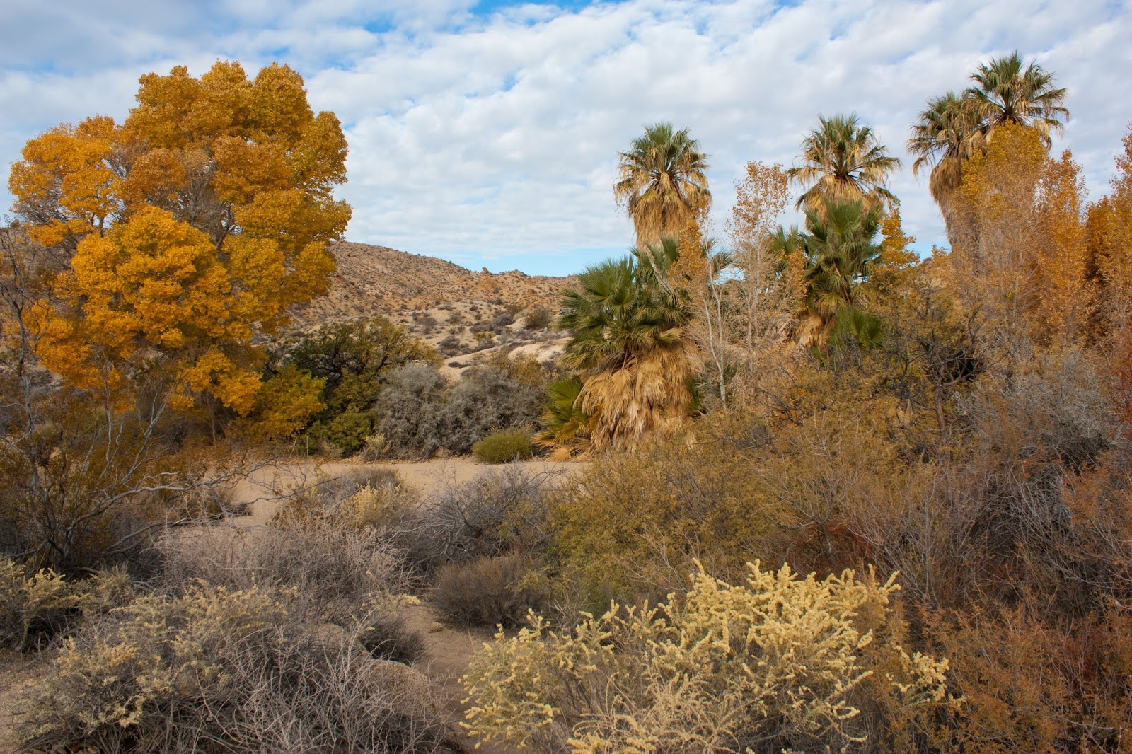
I hiked this trail on an early November morning, driving in from Palm Springs by taking I-10 east and then taking exit 168 and heading north on Cottonwood Springs Road. At the Cottonwood Visitor Center, I turned right onto the road heading towards Cottonwood Campground and the Cottonwood Spring Oasis. I parked at the end of the road, just above the patch of palm trees and cottonwoods at the aptly named Cottonwood Spring Oasis.

Here, a number of fan palms stood by a large cottonwood and a number of smaller ones displaying golden fall foliage. The trees filled the bottom of the wash at the oasis, one of the few water sources in this otherwise bone-dry desert. The spring proved useful first to the Native Cahuilla as a water source and later to gold miners who saw the spring more as a source of water for gold milling.

Cottonwood Spring Oasis
I followed the trail from the parking lot through the oasis towards Mastodon Peak and Lost Palms Oasis; the initial portion was paved with a railing but the trail turned into a sandy wash after passing through the oasis. The trail quickly climbed out of the wash to a rocky saddle, opening up views of a landscape of jumbled boulders. The desert landscape here was awash with fascinating plants: amongst the boulders, I found ocotillo, cholla cactus, mesquite, catclaw, yucca, and creosote. The diversity of desert botanical life here was a reason why one of the initial names proposed for this protected area was Desert Plants National Monument; Franklin Roosevelt's administration ultimately decided on Joshua Tree National Monument when this area was initially preserved.

Ocotillo
One of the more noteworthy plants in this part of the Colorado Desert were the ocotillo, which are spindly, many-armed plants. Although not cacti, the ocotillo's curved appendages are full of thorns.

Along the next half mile, the trail hugged the southern slopes of a hill, with good views of the boulders and plants immediately surrounding the area. At three-quarters of a mile from the parking lot, I came to a junction with a trail heading towards Mastodon Peak on the left; the trail heading straight continued towards Lost Palms Oasis. I took the left fork and followed this well-built trail up a set of rock stairs ascending through a rocky gully.

Trail climbing towards Mastodon Peak
The trail passed by a few collections of jumbled boulders before coming to the base of the highest pile of rocks- Mastodon Peak. Hikers expecting a prominent, soaring summit will be disappointed- Mastodon Peak is small and only sticks about 100 feet out above its surrounding landscape.

The Mastodon Peak summit block resembled the odd rock formations found in the northwestern corner of the park at Jumbo Rocks or the Wonderland of Rocks. It is the result of a similar geologic history: the exposed monzogranite was initially formed as an intrusive igneous rock, meaning that the rock formed from cooling magma deep within the crust. Over time, uplifting and erosion have brought the monzogranite to the surface; physical processes that brought the rock to the surface also resulted in a system of rectangular joints. Erosion along these joints create the distinct jumbled-rocks look of these monzogranite outcroppings.

Mastodon Peak summit block
I followed a social path around the right (east) side of the base of the summit block until coming to a scramble path at the north side of the peak. The scramble was not terribly difficult but did require use of my hands and could pose a challenge to anyone not used to rock scrambling. Hikers who skip the rock scramble can still enjoy a majority of the views described here.

The summit of Mastodon Peak offered a 360-degree of the surrounding desert, a panorama of the southernmost part of the park. The viewshed was actually fairly limited to the north and east, mainly encompassing the nearby Eagle Mountains and Little San Bernardino Mountains. The view to the south was quite impressive though: from the summit of Mastodon Peak, at just over 3400 feet above sea level, I looked past the mountains bounding Cottonwood Canyon down to the low, flat Coachella Valley, which connects to the even lower Imperial Valley. The valley reached its lowest point at the shimmering blue waters of the Salton Sea, an accidental endorheic lake (a lake with no outlet) that sat some 230 feet below sea level. The Santa Rosa and San Jacinto Mountains rose to the west of Coachella Valley, reaching their high point at the soaring summit of San Jacinto Peak, over 10,000 feet above sea level and the sixth most prominent peak in the 48 states. To the right of San Jacinto Peak, I noticed the very top of San Gorgonio Peak, the tallest mountain in Southern California, peeking out over the Little San Bernardino Mountains. At the southern end of the view, it appeared that I could see all the way down to the Peninsular Ranges near the Mexican border.

Salton Sea and San Jacinto Mountains from Mastodon Peak
The recent history of the Imperial Valley and the Colorado Desert is the history of European settlers trying to reshape the desert to their will. The Salton Sea formed due to their actions: although lakes had come and gone in the past in the endorheic basin of the Imperial Valley, the area had small, transient lakes when European settlers first arrived. A plan to irrigate the Imperial Valley by digging a canal from the Colorado River backfired spectacularly in 1905 when the Colorado River redirected its flow from its main channel into the canals feeding into the valley. As a result, the Imperial Valley was flooded until the river banks of the Colorado were restored.

The irrigration scheme was eventually successful- today, the All-American Canal, the world's largest irrigation canal, diverts critical water from the Colorado River to the below-sea level valley. As a result, the Colorado River, sculptor of the Grand Canyon, principal recipient of the Rocky Mountain's annual snowpack, and surely one of the great rivers of the planet, is reduced to a trickle or nothing at all when it enters Mexico, just miles away from its mouth at the Gulf of California. The farmers of Imperial Valley were among the first to tap the Colorado River, laying early claim to precious water rights in a region where water is becoming ever more scarce. The precedence of their water rights have given these farmers priority to the dwindling supply of water in a drought-stricken state, keeping the alfalfa fields surrounding El Centro green through the Valley's blistering heat and ensuring the supply of lettuce and spinach for those Earthbound Farm salad greens clamshells found in American supermarkets throughout the winter.

The Salton Sea remains, kept just barely alive by the fertilizer-laden runoff from the farms, dying as its lakeshore recedes due to increased irrigation efficiency. To many, the Imperial Valley is life: the Salton Sea is wintering grounds for cormorants, pelicans, and many other birds and the lush, irrigated fields provide salads across the continent and a robust agricultural economy in one of the driest and hottest spots in the country. Yet there are more than passing reminders of death and decay here, too. Winds scouring newly-exposed portions of the Salton's former lakebed lift clouds of pesticides and other toxins into the Valley's air. Across the border, south of Mexicali, the once thriving and biodiverse wetlands and riparian forests at the Colorado River Delta are now shrinking in size with no flow in the Colorado.

After admiring the view from the summit of Mastodon and contemplating the role of water in this landscape, I scrambled from the summit back down to the trail. I continued forward on the loop and very quickly arrived at the ruins of the Mastodon Mine. This gold mine was operational during much of the mid-twentieth century and operated until 1971; the remaining structures include a small shack and a mining shaft dug into Mastodon Peak that is now sealed off by a grated gate. Quartz veins in the monzogranite here hold gold, the catalyst for gold prospects at many of the abandoned mines that litter the park.

Mastodon Mine
The presence of gold in the mountains of the park is linked to the region's complex geology. Joshua Tree sits at a unique position on the boundary between the Pacific and North American Plates. While the park itself is firmly on the North American plate, the geology of the area results from both the long transform plate boundary that has resulted in the San Andreas Fault and an area of active continental rifting between the the plates that has opened the Gulf of California. The below sea-level elevation of the Imperial Valley is explained by the fact that two tectonic plates are actively diverging here. Further south, that has resulted in the separation of Baja California from mainland Mexico and the formation of a narrow sea; the Imperial Valley exists because sediments from the Colorado River Delta form a barrier that prevent the Gulf of California from flooding the valley to the north. The San Andreas Fault starts near and runs along the southern boundary of the park, representing a transition from divergent to strike-slip motion between the two plates. Uneven distribution of tectonic stresses along this fault has led to localized areas of crustal compression or extension. Compression has created the Transverse Ranges, which includes both the San Gabriel Mountains near Los Angeles and the Little San Bernardino Mountains in Joshua Tree National Park. Extension has resulted in basins such as the one that holds the megalopolis of Los Angeles.

Past the mine, the trail continued briefly on the ridgeline of Mastodon Peak before crossing to the north of the ridge and dropping into a wash. The plant life here was incredibly varied. One of the more fascinating plants found here was creosote, a very unassuming bush that carries the Spanish nickname "gobernadora," or governess. The first notable aspect of the creosote bush is its smell: lean in and breath on its leaves and you'll smell a distinctive and not unpleasant aroma. This smell is released in the presence of moisture; come to a creosote-laden desert after a rainstorm and the pungent wafts fill the air. The more impressive aspect of the creosote is its ability to compete with other desert plants for water: its nickname comes from its ability to monopolize land and water. Creosote's shallow and extensive root system allows it to draw up water from a wide area while also releasing chemicals that prevent other plants from growing. Humans, it seemed, were far from the only organisms engaged in underhand tactics for securing water in the desert.

Cholla, yucca, creosote
The trail followed the sandy bottom of a wash for about a third of a mile, passing by piles of huge boulders. The trail exited the wash to the right at an unsigned but reasonably well-marked point at which large rocks were laid across the width of the wash marking a change in the direction of the trail. After crossing a low ridge, the trail descended into a second wash, following it briefly before climbing out to the right once again.

Joshua Tree's interesting rocks
The trail descended into a third wash near a spring that nurtured a small oasis. Just north of the wash, a few cottonwoods and a palm tree rose at the head of a small canyon. This was the former site of the Winona Mill: water from the spring here was used to process gold mined at the Mastodon Mine. The mill is entirely gone now.

Small oasis near Winona Mill site
At the bottom of the wash near the Winona Mill site oasis, I came to a trail sign. Across the wash, a clearly defined trail climbed uphill towards the Cottonwood Campground. I turned left here, following the sandy wash itself back towards the Cottonwood Spring Road. Upon reaching the road, I made a left turn and followed the road back to the parking lot at Cottonwood Spring.

Monday, October 3, 2016

Easy Pass

Larches at Easy Pass
7 miles round trip, 2900 feet elevation gain
Difficulty: Moderate-strenuous
Access: Paved road to trailhead, Northwest Forest Pass required

One of the words that make up the name "Easy Pass" is incorrect and it's not "Pass." Easy Pass is a fairly challenging but highly rewarding hike in Washington State's North Cascades that visits a high mountain saddle with views of glaciated peaks, a secluded alpine basin, and a chance to see golden larches in the fall. Although the trail starts in Okanogan-Wenatchee National Forest, it offers access to North Cascades National Park at the pass. Hikers who don't mind tackling a rocky trail with a heavy amount of elevation gain can peer into the remote and unspoiled Fisher Creek Basin, which is ringed by craggy peaks, and Mount Logan, one of the tallest peaks in North Cascades National Park.

Looking for more larch hikes? Consider Lake Ingalls, the Enchantments, Grasshopper Pass, or Maple Pass.

I've hiked this trail twice: on my first visit, low clouds prevented me from appreciating any of the views at the pass but gave me more time to appreciate the many wildflowers from columbine to heather to paintbrush that bloom along the way to Easy Pass in early August. My second visit was on an early October day to see fall colors and perhaps catch the larches at the pass at their peak golden color. Hiking on a day when the forecast called for mostly cloudy skies, I hoped that I wouldn't again get socked in by the clouds once I reached the pass. I accessed this hike from Mazama, which is east of the trailhead on Highway 20; hikers coming from Seattle can reach the trailhead by following I-5 north to Burlington and then taking Highway 20 east from Burlington through North Cascades National Park to the trailhead, which comes after Highway 20 has exited the park proper. There was a small parking lot for about 10 cars; there were plenty of spots left when I arrived early on a Sunday morning. By the time I returned, a few cars were parallel parked on the edge of the lot but it seemed hikers who intended to come here had all found parking; the foot traffic on this trail is much less compared to the nearby Maple Pass Loop.

I set out from the trailhead down a flat path through the forest and quickly reached a well-built log bridge over Granite Creek. Granite Creek is the main drainage for the valley north of Rainy Pass; the bridge across the creek is one of the nicer bridges that I've seen that have a bridge span built out of a single log.

Log bridge over Granite Creek
After crossing the creek, the trail immediately began ascending through a spruce and hemlock forest filled with mossy lichens hanging from trees. The initial ascent was not too steep but the trail picked up the uphill pace through a series of switchbacks after a handful of short boardwalks. The trail was built with a comfortable dirt tread, making the ascent fast and generally pleasant. Easy Pass Creek tumbled downhill to the left of the trail; although the trail never approached the creek closely enough to observe its waters, I was often accompanied by the sounds of cascades on the creek.

When I started paying attention to life at the ground level, I realized that mushrooms were sprouting up all along the trail. While I was unable to identify any, having almost zero knowledge of wild mushrooms, I admired the seemingly diverse set of shapes and colors of the fungi that I spotted.

Mushrooms in the forest
After ascending via some switchbacks, the trail crossed a small stream and then began to flatten out. About a mile and a half from the trailhead, the trail crossed Easy Pass Creek. A number of small logs had been set across the creek at the crossing, which was not very deep or fast but would've been a little bit difficult to rockhop without the logs in place.

The trail tread changed from dirt to rocks after the Easy Pass Creek crossing. In two spots right after the crossing, small streams had repossessed the trail as a streambed. At this point, the vegetation also changed: the forest ended and was replaced with an overgrown meadow. Upon seeing a thick layer of frost coating all the vegetation at this clearing, I realized that it must have been quite cold at upper elevations in the Cascades the previous night.

Morning frost along the trail to Easy Pass
Soon, views opened up ahead of the trail to two rocky peaks, with Easy Pass lying at the saddle in between. Both rocky prominences were a part of Ragged Ridge. Mount Hardy rose across the valley, separated from my position by Highway 20. A few minutes of hiking beyond the creek crossing, the trail emerged onto a talus slope at the base of the southern peak bounding Easy Pass. The sheer walls of Ragged Ridge were extremely impressive, rising almost vertically from the top of the talus slope. During my hike, I witnessed a microwave-sized boulder tumble a thousand feet down this wall; so try not to spend too much time directly beneath the many cliffs on this hike.

At the end of the talus slope, the trail reached the base of a steep slope separating the upper and lower basins of Easy Pass Creek's valley. A sustained uphill climb through a set of switchbacks brought me up to the upper basin. Along the way, the fall colors became increasingly impressive: berry bushes had turned crimson and mountain ash had turned shades of orange and yellow, putting on an impressive display.

Fall colors beneath Ragged Ridge
In August, these same slopes had put on a very different display of color: the verdant summer vegetation was littered with the colors of blooming columbine, fireweed, and other subalpine wildflowers.

Columbine along the trail in August
I soon noticed that the berry bushes had more to offer than just their deep red color: the huckleberries along this trail were ripe! Many of the bushes were loaded with berries. I stopped for a wild berry snack break, a welcome and delicious respite from the climb.

Ripe huckleberries along the trail
Huckleberry bushes filled the upper basin. From this vantage point, I could finally see forward to the pass, which lay at the top of a talus slope at the saddle between the two summits on Ragged Ridge. The bottom of the basin was littered with huge rocks scattered amongst the bushes, a reminder that even these mountains do not last forever. I spotted scurrying and heard the meeps of pikas that lived in the huge talus slopes.

Meadow in the basin before the final ascent to the pass
The trail began to climb in earnest again soon afterwards, embarking on a set of frequent and sharp switchbacks through a hillside entirely full of red berry bushes. As I climbed continuously upward, more and more peaks began to appear to the east. Mount Hardy was joined by Porcupine Peak and the distinct shape of Golden Horn. Golden Horn's equally impressive sibling, Tower Mountain, never appeared during the hike as it is situated directly behind Mount Hardy from the Easy Pass angle.

Golden Horn and Hardy with fall color on the trail
The final ascent to the pass involved very many switchbacks. The trail climbed to the base of the cliffs of Ragged Ridge, then hugged the foot of the cliffs and entered the talus slope just below the pass. The final few switchbacks ascended through loose scree; as the trail was narrow, quite steep, and consisted of loose rocks, this was probably the most difficult portion of the hike.

Switchback on the approach to the pass
Luckily, those switchbacks marked the end of the hike and my arrival at Easy Pass. After finally reaching the heather meadows and the larch grove at the pass, I continued following the trail onward past the North Cascades National Park boundary marker to an incredible ledge overlooking the pristine Fisher Creek Basin. The views were stupendous: Fisher Peak and Mount Arriva towered over the basin and Black Peak rose menacingly further to the south.

Fisher Creek Basin with Fisher Peak and Black Peak rising behind
Although the larches were still green and the views of nearby peaks were covered by clouds in my August visit, I found many blooming wildflowers at the pass at the height of summer. The tiny pink bells of heather covered the pass while patches of western anemone and paintbrush dotted the heather meadows.

Western anemone (pasqueflower) and heather along the trail in August
Looking to the west towards the outlet of Fisher Creek Basin, I saw the massive form of Mount Logan, one of the few peaks in Washington State that breaks 9000 feet. Two glaciers poured down its slopes: this is one of the few trails from which to catch a fairly close-up view of a major peak and glacier in the North Cascades.

Mount Logan
I soaked in the views before heading back to the pass itself to admire the stand of golden larches. The larches coated the pass itself and spread onto the meadow-filled shoulder of Ragged Ridge south of the pass. Whenever the sun came out, it set the larch needles ablaze with color, which was a truly spectacular scene.

To see more of these odd deciduous conifers, I wandered around the larches on a social trail leading southeast from the pass. This path climbed uphill for a bit to even more golden larches and a clearer view of the impressive sharp summit of Mesahchie Peak, the high point of Ragged Ridge, and of Klawatti Peak far away. The large Klawatti Glacier seemed to cling precariously to the mountain wall between the arete of Klawatti Peak and the fin of Austera Peak; it's actually one of the larger glaciers in both Washington State and the contiguous United States.

Mesahchie Peak viewed from above Easy Pass
Klawatti Peak and Austera Peak viewed from above Easy Pass
After sufficiently enjoying the views near the pass, I worked my way back down to the trailhead, stopping often to enjoy the trail's October huckleberry harvest.

Saturday, October 1, 2016

Grasshopper Pass

Larches brighten the North Cascades at Grasshopper Pass
10 miles round trip, 1500 feet elevation gain
Difficulty: Moderate; a long hike with no steep sections
Access: Rough, rocky, narrow gravel road to trailhead, Northwest Forest Pass required

The landscape near Harts Pass in Washington State's North Cascades is littered with active and abandoned mines where prospectors sought and still look for gold in the hills. The most reliable gold in this part of the Cascades, however, appears for a few weeks each autumn when the expansive larch forests near the pass assume their fall colors. While I hesitate to make such a sweeping claim as I've yet to hike extensively in the Harts Pass area, I doubt there's any better hike to see autumn larches in the Pacific Northwest than this out-and-back hike along the Pacific Crest Trail. Grasshopper Pass would be a worthy destination any time of year: the entire length of the trail follows a high ridgeline with wide-open views of the North Cascades and the Pasayten Wilderness. Golden larches bring a particular magic to the landscape in late September and early October of each year, setting the mountain slopes ablaze with color. This hike is remote and quite a long drive from any metropolitan area, so much of this spectacular landscape can be enjoyed with only a fraction of crowds found along Highway 20 or in the Enchantments. The catch? Driving up the narrow, steep, and rocky Harts Pass Road to reach the trailhead.

Looking for more larch hikes? Consider Carne Mountain, Cutthroat PassEasy PassLake Ingallsthe Enchantments, or Maple Pass.

I hiked to Grasshopper Pass on an early October Saturday with rain in the forecast. I had drive out to Mazama the previous night from Seattle; that morning, I set out early from Mazama, following the Lost River Road northwest from the center of the town. The road narrowed and soon became a heavily washboarded gravel road. After entering Okanogan-Wenatchee National Forest and passing the Ballard campground, the road came to a junction: the road heading straight led to the River Bend campground and the road that turned sharply to the right led towards Harts Pass. I turned right for the 10-mile drive to Harts Pass, a road with a notorious reputation as one of the more dangerous roads in the state.

The road didn't end up being so bad. Yes, the road was only wide enough for one car for most of its length, but there were sufficient turnouts to allow one or the other car to pass. The most infamous stretch, a section of narrow road carved into a cliff with many blind turns, was harrowing but short and still featured enough turnouts to be safely navigated; it also came fairly early in the driving ascent. You'll want to avoid driving if you're afraid of heights and it's certainly not a road for novice mountain drivers, but there wasn't anything about this road that you wouldn't encounter driving other dirt forestry roads. I drove up in a high clearance 4WD, but there were plenty of sedans (including a Prius!) that had made their way up. Once at Harts Pass, I turned left at a junction for the Meadows Campground and followed that gravel road past the campground to its dead-end at a trailhead for the Pacific Crest Trail. This stretch of road was fairly rocky, which made me glad I had a high-clearance vehicle, but it should still be negotiable for most cars. There was parking for about 10 cars.

From the trailhead, I followed the wide trail next to the empty information board at the end of the lot. I almost immediately came to a junction with the Pacific Crest Trail, with the trail to the right leading the final thirty-some miles to Canada and the trail to the left heading towards Rainy Pass and Mexico. I took the left fork. The trail exited the forest almost immediately and entered a boulder field with views of the first larch grove of the hike straight ahead.

The early morning sunlight made the golden larch needles glow. The timing of my hike was perfect: all of the larches here were at peak color. Other vegetation contributed nice reds and greens to the vivid fall scene.

Pacific Crest Trail south of Harts Pass
The trail then passed through a second talus slope before coming upon a second larch grove. As I hiked along the boulder field, I caught nice views of the landscape surrounding Harts Pass. Devils Peak and Robinson Mountain, two peaks in the massive and remote Pasayten Wilderness, lay behind a flat ridge; closer in, I could see the Harts Pass Road up which I had driven and the flattened summit and lookout tower of Slate Peak, the highest road-accessible point in Washington State.

Devils Peak, Robinson Mountain, and autumn larches
The second larch grove was really a larch forest: hundreds of larches coated the entire north side of the ridge here. As clouds moved in and out, sunlight danced on the larch needles.

While passing through the second grove, the trail rounded the ridge and made a sharp nearly 180-degree turn to the south side of the ridge. The change in scenery was immediate: the more subdued profiles of the Pasayten peaks was replaced with the craggy peaks of the North Cascades. The first peak I noticed in this new view was Silver Star, a massive granite peak carrying a sizable glacier on its north face. Far below, Trout Creek carved out a rugged canyon. The canyon walls were barren, having been scorched by a 2003 wildfire that had also torched many of the trees along Harts Pass Road. The many summits of Gardner Mountain lay to the south of Silver Star and the sharp pinnacles of the Needles were just to its right. The 2003 fire had burned right up to the ridgeline, so the golden larches that I had seen north of the ridgeline were now replaced with burnt husks of trees.

Gardner Mountain and Silver Star rise above Trout Creek Canyon
As I began to hike west along the mountainside, a set of peaks to the southwest caught my attention as well: farther away, I could see the glacier-sculpted forms of Tower Mountain and Golden Horn, while closer in I spotted Azurite Peak. Grasshopper Pass, my destination for the day, was visible as well: it was the low saddle situated directly beneath Azurite Peak. Hiking further along, Black Peak entered the southern skyline as well, its pyramidal summit fading in and out as storm clouds moved in from the west.

Tower, Golden Horn, Black Peak, and Azurite Peak from slopes of Tatie Peak
About two miles from the trailhead, I came to a high saddle between the unnamed peak under which I had been hiking and Tatie Peak. At 7000 feet, this was the highest point along the hike. A grove of larches started at the saddle and poured down the north slope of the mountain.

Larches at Tatie Peak saddle
Views towards the north encompassed most of the forested Ninetynine basin and included Slate Peak and the mountains of the Pasayten Wilderness. North of Slate Peak, at the foot of Tamarack Peak, I could see landscape disturbances related to the Glory Hole Mine, where prospectors one dug up the mountainside searching for gold. The ghost town of Barron lay just below that former mine site, a boomtown that came and went with the prospect of gold.

View across Ninetynine Basin to Slate Peak and Pasayten summits
The trail swung back to the south side of the ridge as it traversed the slopes of Tatie Peak. As I hiked towards the saddle between Tatie Peak and the next unnamed prominence on the ridge, I inched closer to an incredible forest of larches growing high on the headwaters of Trout Creek. Golden Horn, the Needles, Silver Star, and Tower Mountain formed an imposing backdrop.

The Needles, Tower, Golden Horn, larches
At the end of three miles, the trail came to the second saddle. The west side of the saddle featured views up the drainage of Slate Creek to Jackita Ridge and the glacier-covered massifs of Crater and Jack Mountains in North Cascades National Park. I also found the first clear view of the massive cliffs of Mount Ballard.

View up the Slate Creek drainage to Jack and Crater Mountains
Mount Ballard
Past this saddle, the trail entered the large larch forest. While larches can be found in many parts of the eastern Cascades, the sheer quantity of larches on this hike clearly distinguishes it from well-known larch marches such as Maple Pass, the Enchantments, or Lake Ingalls. Other larch marches satisfy hikers with small groves or a few individual larches; the last two miles of the hike to Grasshopper Pass deliver a mountainside full of larches and views to an entire basin of larches. Every peak surrounding the Trout Creek headwaters was dotted with larches: gold was everywhere in these mountains.

Larches
In the final two miles, the trail descended from the second saddle via two switchbacks and then passed through two distinct larch groves to come to a final stretch along a scree slope. While views were plentiful along the earlier stretches of the trail past Tatie Peak, the views near these larch groves were more confined to nearby ridges, as the trail dropped substantially in elevation from its position on Tatie Peak. The trail began ascending as it entered a long scree slope. While much of the trail is cut into steep mountain slopes, this was the only portion of the hike where the trail seemed a little more precarious: the trail was fairly narrow here as it cut across the scree. However, it's unlikely to present a problem to any hikers except those with a fear of heights.

While I crossed the scree slope, thicker clouds finally rolled in overhead and the forecasted precipitation arrived in the form of flurries. Seeing that Grasshopper Pass was nearby, I chose to press on. As I rounded a bend in the ridge, Azurite Peak appeared in front of the trail, rising above Grasshopper Pass; a few more minutes of hiking brought me to dense larch forests surrounding the pass.

Azurite Peak rises above larches at Grasshopper Pass
The views at Grasshopper Pass are actually more limited than the views early on near Tatie Peak, but the proximity to some enormous mountains more than makes up for the fact that fewer peaks are visible here. I found a spot just beyond the pass itself with a view of the enormous face and glacier of Azurite Peak. Azurite's ridgeline connected directly to the menacing cliffs of Mount Ballard. From Grasshopper Pass, I could see the switchbacks on the Pacific Crest Trail as it dropped down to forested Glacier Pass below.

Azurite Peak viewed from Grasshopper Pass
Although the weather had appeared to deteriorate earlier, the sun soon returned as I spent the good part of an hour at the pass. Bright sunlight on the larches made the golden hues of the tree shine even more than they already did.

Grasshopper Pass
I ran into numerous PCT thru-hikers along the trail. The Harts Pass area is only about two days by foot from the Canadian border, so quite a few of the hikers seemed cheerful about the upcoming conclusion to their hikes. I was particularly impressed by a mother-son duo who I ran into at Grasshopper Pass: I'm more than a little jealous that the kid I met there got to hike the PCT before age ten. Otherwise, I was pleasantly surprised with the small number of hikers I encountered: there were less than 15 other day hikers on the trail all day, which is remarkable considering I came on a weekend during peak foliage. While not abandoned, this hike definitely has low traffic by Washington standards.

I enjoyed the views and the sunlight on the larches a little longer before backtracking to the trailhead the way I came. All in all, the trail was extremely beautiful and not hard to hike, which makes for an enjoyable combination. The constant vistas of the trail are undoubtedly stunning at any time of year, but this really is a hike for the fall; I've yet to see anyplace with a larch display rivaling that seen along the PCT in the two miles north of Grasshopper Pass.

The Needles and golden larch needles at Grasshopper Pass