Wednesday, July 27, 2022

Crystal Lake (Mammoth Lakes)

The Mammoth Crest rises over Crystal Lake
3 miles round trip, 800 feet elevation gain
Difficulty: Easy-moderate
Access: Paved road to trailhead, no parking fee required

Crystal Lake is a reasonably short and sweet and extremely popular hike to a small alpine lake above the main Mammoth Lakes Basin in California’s Eastern Sierra Nevada. The ___-mile round trip hike starts from an incredibly popular trailhead at Lake George and follows the first mile of the Mammoth Crest Trail up forested mountain slopes to some fabulous views of the Mammoth Lakes Basin before arriving at the destination lake. While this is certainly an enjoyable and scenic hike, it is also very busy, so you may want to consider quieter options on summer weekends and holidays. Additionally, while Crystal Lake is pretty, there are also far prettier landscapes nearby- although many of those destinations do require more involved hikes. This is a worthwhile hike, but it may not deserve a spot at the top of your list if you have limited time around Mammoth.

I hiked to Crystal Lake on a July holiday weekend trip to Mammoth with Anna and mom. Mammoth Lakes is a long way from any major metropolitan area, at over five hours of driving from either the San Francisco Bay Area or Los Angeles; you’ll reach the town via US 395 regardless of which direction you come from. South of Lee Vining, exit US 395 for Highway 203 and follow 203 west through the town of Mammoth Lakes; if you drive straight and make no turns, you’ll end up on the Lake Mary Road, which climbs out of the far end of town and then brings you up into the Mammoth Lakes Basin. After the road reaches Lake Mary, turn left for the Around Lake Mary Road just after passing Pokenobe Marina. Follow this road across a bridge over the outlet stream of Lake Mary, then turn right onto the narrow but still paved Lake George Road. Lake George Road winds briefly through the forest to a relatively large, loop-structured parking lot.

It’s important to arrive early at the trailhead: the parking lot at Lake George is one of the busiest in the Eastern Sierra Nevada and can become a traffic nightmare later in the day. Every spot is usually taken and entering and exiting the lot itself can be challenging due to the large number of cars that circle the lot, looking for a chance to park. Get here early to secure a spot and avoid the nuisance of midday traffic.

Before starting the hike, we walked from the parking lot down to the shore of Lake George. Lake George is a stunningly beautiful subalpine lake at the base of Crystal Crag and the Mammoth Crest; the toothlike form of Crystal Crag from the lakeshore is one of the iconic views of the Eastern Sierra.

Crystal Crag rising over Lake George
After appreciating Lake George, we were ready for our hike. We backtracked to the entrance of the parking lot to find the Mammoth Crest Trailhead, which was marked by a signboard with information for backpackers entering Ansel Adams Wilderness. The trail began to climb immediately from the trailhead, making a steady ascent through forested slopes. For the first 400 meters of the hike, the trail stayed fairly close to a long driveway leading up to multiple houses on the slopes above Lake George. Finally, at a quarter mile from the trailhead, the trail passed the end of that driveway; continuing the climb, it soon crested a forested ridge that had some openings delivering partial views of Lake George below and the rocky alpine wall of the Mammoth Crest to the southeast.

Crystal Crag and the Mammoth Crest
At a half mile, the trail began a moderately steep switchback ascent. While not necessarily difficult, this switchback passage maintained a constant uphill grade over just more than the next half mile, making this the most extended climb of the hike. After a couple of switchbacks, the trees began to thin out slightly, opening views of both the rocky Mammoth Crest above and the many shimmering blue lakes of the Mammoth Lakes Basin down below. Lake George lay directly below and was particularly spectacular; Lake Mary lay beyond and just downhill, with the red volcanic rock of the Sherwin Range bounding the other side of the Mammoth Lakes Basin. The Sherwin Range forms the southern boundary of Long Valley Caldera, the footprint of a massive volcano that formed in an eruption over 700,000 years ago.

Lake George and Lake Mary
After a few switchbacks with lake views, the trail returned to the forest, continuing its constant climb, until the Mammoth Crest Trail met with the Crystal Lake Trail at 1.1 miles from the trailhead. Here, I took the left fork to hop on the Crystal Lake Trail; this trail finally flattened out, traversing a mountain slope and coming out to an open viewpoint atop granite cliffs that rose over 600 vertical feet above Lake George. From this lofty, open viewpoint, we could see Horseshoe Lake and Lake Mamie, in addition to the view of Lakes George and Mary that we had earlier.

Mammoth Lakes
The Crystal Lake Trail continued through the forest to the shore of Crystal Lake, dropping slightly as it approached the lake. At about 1.4 miles, we arrived on the lakeshore, where we had a lovely view of the rock wall of the Mammoth Crest rising behind the lake’s sparkling waters. Crystal Crag rose to the southeast across the lake, although from this perspective it had lost the sharp and more rugged profile that it projects when viewed from Lake George. The first spot where the trail met the lakeshore was quite crowded, with many hikers ending their hike here. We followed the path along the west side of the lake to find a quiet spot to enjoy the lake before returning to the trailhead.

Crystal Crag and the Mammoth Crest rise over Crystal Lake
This was a pretty hike with plenty of great views; however, it was quite crowded as well, with hundreds of hikers on the trail during our hike and a completely jam-packed parking lot both when we arrived and when we left. Crystal Lake can be a worthwhile destination when it’s less crowded, but I’d recommend hikers to tackle the admittedly longer hikes to Little Lakes Valley or the Twenty Lakes Basin before choosing this slightly-too-popular hike.

Friday, July 22, 2022

Sierra Buttes Lookout

Sierra Buttes Fire Lookout
5 miles round trip, 1600 feet elevation gain
Difficulty: Moderate
Access: Good paved but narrow road to trailhead, no fee required

Sierra Buttes is one of the most prominent peaks in the northern section of California’s Sierra Nevada, with a massive eastern headwall that makes it one of the most scenically impressive mountains in the state north of Tahoe. The fire lookout perched atop its highest point is reached by a hair-raising walk up a steel staircase and delivers fabulous views of Northern California, from the Coast Range to the Cascades to the Great Basin Desert. The ridge hike to this summit packs in views of forested peaks and jewel-like lakes, with plenty of wildflowers in early summer; while this hike doesn’t quite live up to the scenery standard set by the High Sierra further south, it is one of the most enjoyable and worthwhile hikes in its part of the state.

There are many ways to get to ascend Sierra Buttes; by far the easiest route involves driving a 4WD high clearance vehicle to the base of the lookout and simply ascending three flights of steel stairs to the summit. Most visitors, however, will find a hike ascent along the mountain’s north ridge from Packer Saddle to be the most rewarding, as this route packs in plenty of views along its moderate climb to the mountaintop. My friends and I, who were visiting Sierra Buttes after a holiday weekend stay in North Lake Tahoe, took the hike up from Packer Saddle; we also paid a brief visit to Lower Sardine Lake, a highly worthwhile stop on the drive in that provided us a beautiful view of the great headwall on the eastern side of the mountain. Packer Saddle is just over an hour driving from Truckee and at least 2.5 hours of driving from Sacramento.

Sierra Buttes and Lower Sardine Lake
We followed Gold Lakes Highway uphill for 1.3 miles from Highway 49, passing some jaw-dropping views of the precipitous east face of the Sierra Buttes. At the junction with the Sardine Lakes Road, we turned left; after crossing a bridge, we then turned right onto Packer Lake Road (although it’s also worth it to drive to the end of the road to see Sardine Lakes!). After turning onto Packer Lake Road, we drove uphill along a very well-maintained paved road with clear lane markings for 2.5 miles to Packer Lake Campground; past the campground, the road became very steep and narrower but remain paved, ascending through hairpin switchbacks until reaching the top of a ridge at 4.5 miles past the turnoff from Sardine Lakes Road. The paved road ended here; a final quarter mile of good gravel road descended along the ridge to the trailhead at Packer Saddle, where there was room to park about 20 cars. There is no fee and no restroom at the trailhead.

We headed south along an old service road from the trailhead at Packer Saddle. This road climbed steeply through the pine forest, quickly gaining the top of the ridge while making a stiff ascent. Blooming wildflowers around the trail provided interest and made the climb a little easier: paintbrush and lupine were particularly common here during our early July visit.

After a half mile of hiking from the trailhead, the trail narrowed to a single track and came to a flatter section of the ridge; at the fork between the wider road and the single track, I took the right fork for the single track trail (a rock barrier blocking the left fork clearly indicates not to head in that direction). Here, wildflowers bloomed profusely over an open ridgetop: the blooms of golden wyethia were particularly widespread and beautiful. The lower density of trees here also opened views off to both sides of the ridge as well as providing the hike’s first view of the lookout atop Sierra Buttes. When the flowers bloom here in spring and early summer, this is an absolutely beautiful stretch of trail that is certainly among the highlights of this hike.

Flower-filled ridgeline
Wyethia in bloom
At just under one mile from the trailhead, the flat trail ended at a junction with the Pacific Crest Trail, which crossed over the Sierra Buttes Trail here. Oddly enough, the PCT never follows any section of the north ridge of Sierra Buttes, missing out on many of the great views offered by this mountain. After passing the trail junction, we began to ascend at a steady grade along the ridge. The ridge was forested to the west but generally open to the east, providing views of the Sierra Buttes ahead and to the forested mountains in the east. Towards the top of this ascent, at 1.2 miles from the trailhead, we caught some nice views of the two Tamarack Lakes in the basin below.

Overlooking Tamarack Lakes
The trail reentered the forest on the west slope of Sierra Buttes and continued climbing steadily upward. At 1.6 miles from the trailhead, a short spur leading left at a switchback brought us to a spectacular viewpoint above Young America Lake. This small lake was cradled in a rocky cirque directly below us and had a spectacular blue-green color when it was lit by the sunlight. From this spot, we also had a jaw-dropping view of the massive northeastern headwall of Sierra Buttes.

Young America and Sardine Lakes
Shortly beyond that first viewpoint of Young America Lake, the trail reemerged along a clearing on a flatter stretch of the ridge. The views of Young America Lake were slightly blocked here, but the view of the great cliffs of Sierra Buttes and the small lookout perched atop the highest pinnacle were quite spectacular. The trail came to another junction at 1.8 miles; I continued following the single-track trail closest to the ridge, eschewing the wider 4WD road that came up from the right.

Sierra Buttes and the summit lookout
The trail continued climbing steeply through the forest after the junction, making multiple switchbacks as it pushed towards the summit. At 2.1 miles, the single-track trail merged with the 4WD road that leads to the summit. It’s important to make note of this junction: it is easy for hikers to miss this turn on the way down. Joining the 4WD road, we continued to head uphill through a series of switchbacks. This wide, rutted gravel road soon broke out of the forest onto the windswept alpine slopes of the upper mountain, opening up incredible views to the north and west. At the northern end of various switchbacks here, we caught incredible views of the vertical eastern headwalls of the Sierra Buttes and saw the lookout perched precariously atop the mountain’s highest pinnacle.

Jackson Meadows Reservoir and Sierra Crest
Views to the south opened up as the 4WD road ended at the base of the Sierra Buttes’ summit block. From here, a three-part steel staircase climbed a final 150 feet to the very highest point of the mountain. It’s extraordinary that this ladder was installed in such a precarious place. Some hikers will find the staircase to be too much; rest assured that reaching this point still guarantees sweeping views of the Central Valley, the Coast Range, Lassen Peak to the north, and the crest of the Sierra Nevada to the south.

Looking up to the Sierra Buttes Lookout
The final ascent up the three steel staircases to reach the summit were the most thrilling stretch of this hike. While the staircases may look terrifying to some, I found them fairly straightforward to go up and down in person; the last of these staircases, which is airier underneath than the first two, is a bit more likely to trigger acrophobia. At the end of the ladders, a final ten meters of uphill through a stone pile brought me to the foot of Sierra Buttes lookout. A short steel staircase brought me to the fire lookout’s upper deck, the highest point of the hike on top of this 8591-foot high summit. Not everyone will be okay with the ladders: three of the five in our group went up the ladders, while two decided to stick to the base and enjoy the views from there.

Starting up the staircase
Looking down from the top of the staircase
I made my way gingerly around the upper deck of Sierra Buttes lookout, with a steel lattice floor being all that separated me from a thousand-foot vertical drop down the east face of the mountain. The airiness of this drop was thrilling.

Eastern headwall of Sierra Buttes
The 360-degree view achieved by going around the deck of the lookout was too packed with peaks and landmarks for me to note them all, but I’ll give it a go. To the south, we could see along the crest of the Sierra Nevada towards snow-covered mountains near Donner Pass and Lake Tahoe, while the drier but still noteworthy peaks of the Carson Range were visible further east. Jackson Meadows Reservoir was visible amidst the forested slopes of the Sierra. Sierra Valley, a flat basin to the east over Yuba Pass, was somewhat visible, with layered mountains of the Basin and Range visible beyond it. The Sardine Lakes were visible directly below the lookout to the east.

To the west lay the vast Central Valley. Sutter Buttes- a tiny, isolated range of hills in the middle of the valley- stood out from the flat farmland. Across the valley rose the Coast Ranges, which rose from more hill-like forms in the south to more impressive heights in the north, with Snow Mountain, a 7000-foot peak directly across the valley, especially notable. Mount Diablo was visible far to the south- it was crazy to think that I could see this Bay Area icon from both Sierra Buttes and from where I lived, nearly a five-hour drive away. The Yuba River's deep canyon was cut into the forested slopes of the Sierra Nevada below me to the west, while the Sierra Nevada became progressively more tame as it headed north, the rocky peaks fading into forested and rounded ridges. Lassen Peak, a great plug dome volcano and the southernmost peak of the Cascades, broke that monotony to the north; on a clear day, I imagine that Mount Shasta, the greatest of the California Cascade volcanoes, would be visible from here, but it was a bit too cloudy on the day of my visit.  

Looking west into the Yuba River watershed
Sardine Lakes below, Sierra Valley in the distance
Lassen Peak
Mount Diablo across Central Valley
Sutter Buttes, Coast Ranges, Central Valley
The inside of the fire lookout is still furnished with a refrigerator and a stovetop, from the days when Sierra Buttes Fire Lookout was an active fire lookout. At the time of writing (but likely for not too much longer), the Sierra Buttes and the Yuba River watershed remain one of the few mountainous areas of Northern California that have not been hit by the megafires devastating California: the 2021 Caldor Fire, the 2020 North Complex, and the 2021 Dixie Fire devastated the Feather and American River watersheds to the north and south of the Sierra Buttes, respectively. For the moment, the view from the lookout still covers a landscape that is largely green and remains covered with conifers.

The hike to the fire lookout atop Sierra Buttes is one of the premier hikes of the northern Sierra Nevada. The trail combines a good workout with stellar views, a fun staircase ascent, and lots of wildflowers. While this is a relatively popular hike for the region- we saw upwards of twenty hiking groups over the course of the day- it is still reasonably peaceful and far quieter than the busy trails of the Tahoe region. Highly recommended.

Wednesday, July 6, 2022

Columbine Lake (Sequoia National Park)

Sawtooth Peak above Columbine Lake
13.5 miles round trip, 5000 feet elevation gain
Difficulty: Strenuous
Access: Narrow road to trailhead with unpaved sections; Sequoia National Park entrance fee required

The intense blue waters of Columbine Lake, set in a desolate granite bowl beneath the gnashing spires of the Great Western Divide, make for one of the most scenic destinations in the entire Sierra Nevada. The hike to reach this lake, which starts in Sequoia National Park’s Mineral King Valley, is an extremely challenging slog over rocky Sawtooth Pass that can be done in a very long day or as a backpacking trip. Along this trail, hikers are treated to constantly spectacular scenery, from the views over Mineral King to Black Wolf Falls to the sparkling waters of Lower Monarch Lake beneath Mineral Peak to the views of Mount Whitney from Sawtooth Pass. While the hike is straightforward through Lower Monarch Lake, the crossing of Sawtooth Pass utilizes an excessively route that I can not in good conscience characterize as a hiking trail; the closest comparison I can make here is to the climb up Asgard Pass in Washington State’s Enchantments region. Additionally, as Columbine Lake is on the other side of the Great Western Divide from Mineral King, day hikers must cross Sawtooth Pass not just once but twice(!) in one day. Sawtooth Pass is also at a high elevation, topping out at over 11700 feet, so acclimatization prior to the hike is recommended and altitude sickness can be a real concern. Additionally, the road to Mineral King is notoriously narrow and winding. Hikers who can deal with this trail’s challenges and the tough drive to get here will be treated to an extraordinary High Sierra outing.

I hiked to Columbine Lake during a Labor Day weekend trip to Sequoia National Park. I had initially hoped to head to the Eastern Sierra that weekend, but a statewide US Forest Service closure meant that Sequoia National Park was one of the few spots in the Sierra Nevada that I could visit without reserving a permit. I chose to hike in the Mineral King region, which I had loved when I first visited during my middle school years but had not returned to since. As this was a very strenuous hike and there was just a bit over 12 hours of daylight at that point in the year, I planned to hit the trail before sunrise so that I could maximize my time in the high alpine environs of the Great Western Divide.

Mineral King Valley is more than four hours driving from either the Bay Area or the Los Angeles area, so it requires at least a full weekend commitment for most people. To reach Mineral King, I left Highway 99 in the Central Valley at exit 97 for Highway 198, which I followed east past Visalia and Three Rivers. About five miles after passing the Village Market/Pizza Factory area in Three Rivers, I made a right turn onto the Mineral King Road. I followed Mineral King Road for the next 24 miles until I arrived at the Sawtooth Trailhead, just short of the road’s end at the Franklin/Eagle Lakes Trailhead. Mineral King Road is infamous for its windiness: the road makes nearly 400 curves on its way up from Three Rivers into the valley of the East Fork Kaweah River. There are no lane divides along most of this road and in some areas it’s wide enough for only a single car; as the road climbs through incredibly steep terrain, there are frequently sheer drop-offs to the south side of the road. The road is paved until the Atwell Mill area but the final 8 miles of the road is alternatingly paved and unpaved, with some bumpy portions. Standard sedans should be able to handle this road fine- just drive slowly and expect to spend an hour and a half driving up.

The Timber Gap Trail departs from the north side of the Mineral King Road at the Sawtooth Trailhead, although there are parking areas on both sides of the road here as this is probably the most popular backcountry trailhead at Mineral King. I started out on the Timber Gap Trail, which ascended aggressively up the brushy, open slopes on the south side of Empire Mountain. Views of Mineral King Valley immediately began opening up behind me, including that iconic scene of aspen-dotted meadows in the valley beneath the pyramidal form of Vandever Peak. At the end of a broad switchback in the trail, I had a nice view of a couple tiers of Black Wolf Falls, a stair-step cascade along Monarch Creek that gradually tumbles down the mountain. The falls were not terribly impressive late in the summer, so long after the end of the snowmelt, but when I had seen them in a past June visit to Mineral King these falls had been roaring.

Mineral King Valley
After 0.6 miles, I arrived at a junction: while the Timber Gap Trail continued ahead, the Monarch Lakes Trail turned sharply to the right here. I took the Monarch Lakes Trail, which began cutting to the east along the lower slopes of Empire Mountain. The very best views of Mineral King Valley along this hike came here, but they gradually faded as the Monarch Lakes Trail began winding into the ravine carved by Monarch Creek. The ascent along the trail was initially fairly gentle leaving the junction with the Timber Gap Trail but got steeper as the trail entered the ravine. This stretch of the trail passed a few pretty drops along Monarch Creek, including a waterfall on a tributary stream that tumbled down a 15-cascade directly into Monarch Creek.

At 1.3 miles, I arrived at Groundhog Meadows, a small but pretty meadow nestled beneath the awesome cliffs of Empire Mountain. Here, the trail crossed Monarch Creek and then began a long climb up the slopes on the south side of the creek. The trail ascended about 1200 feet over the next 2 miles through steady switchbacks, which kept the grade reasonable and prevented this stretch of trail from being too steep. The trail alternated between forest and meadows, with a mix of rocky and dirt trail treads, although forest with a comfortable dirt tread was dominant here. I had a few nice views west towards Paradise Peak and the mouth of Mineral King Valley as well as glimpses to the northeast of Empire Mountain across the ravine of Monarch Creek.

Empire Mountain rising over Monarch Creek's valley
At 3.3 miles, the trail wrapped around a ridge and entered an open, sloped meadow with lovely views of the Eagle Crest and White Chief Mountain across Mineral King Valley. A few grouses going about their morning business were startled as I hiked by and scurried into the bushes. Shortly afterwards, at about 3.4 miles from the trailhead, I came to a junction with the Crystal Lake Trail, which branched off to the right. I stayed on the Monarch Lake Trail, which continued ascending through switchbacks until rounding a ridge at elevation 10100. The forest that had covered the previous stretch of the trail suddenly ended as the trail emerged on a rugged, rocky mountainside with massive Empire Mountain directly across a valley below and the white granite wall of Sawtooth Peak rising straight ahead. For the following three-quarters mile, the trail was cut into the steep mountainside, a dramatic balcony trail with continually fantastic and open views. Looking back to the west, many of Sequoia-Kings Canyon’s notable features- including Castle Rocks and Big Baldy- were visible in the distance.

Sawtooth Peak and the trail to Monarch Lakes
The great wall of Sawtooth Peak towered before me, with the precarious path to Sawtooth Pass visible to the left (north) of the summit. I spotted the route climbing up through a loose scree slope, then cutting to the left and switchbacking uphill before disappearing as it climbed ever higher.

Preview of the loose scree approach to Sawtooth Pass
At the far end of the dramatically cut trail, I entered a small, colorful basin dotted with ancient foxtail pines, with sharp Mineral King rising overhead. The reddish color of the rock here is due to the underlying metamorphic rock that characterizes Mineral Peak and parts of the Mineral King Valley- these colorful rocks were once mined for silver by early European American arrivals, who named this valley for mining promises that never truly panned out. The foxtail pines here were gnarled and shaped by the wind- these trees are cousins of the more elderly bristlecone pines, and while foxtail pines can live for a long time, too- recorded specimens exceed 2000 years in age- they aren’t even the oldest trees in Sequoia National Park, where a number of 3000 year old giant sequoias have been found.

Colorful Mineral Peak rising above the Monarch Lakes basin
At 4.5 miles, I arrived at Lower Monarch Lake, a small but pretty natural lake nestled in a colorful basin between sharp Mineral Peak on one side and the white granite wall of Sawtooth Peak on the other side. Upper Monarch Lake- a larger lake held back by a dam- lies uphill of the lower lake, but I skipped it on my trip as my focus was on crossing Sawtooth Pass and reaching Columbine Lake. Lower Monarch Lake is a popular backcountry camping area and even has an exposed toilet to the northeast side of the lake.

Lower Monarch Lake
The Sawtooth Pass Trail left from near the toilet at Lower Monarch Lakes, heading to the north along the base of the Sawtooth granite wall. The trail was initially flat but soon entered a boulder field where it began to ascend aggressively via switchbacks. Here, the trail began to lose definition and devolved into multiple sets of social paths; most of these carry you up to Sawtooth Pass, but it’s a good idea to stick to the most established path to avoid dead-ends and less forgiving terrain.

The trail from Lower Monarch Lake to Sawtooth Pass ascends 1300 feet in less than a mile- it is excessively steep. The primary path switchbacked up into a loose, gravelly, and steep slope of miniature scree to start; as footing here was quite loose, I felt as though I was sliding back a step for every two steps I hiked forward. After a handful of switchbacks, I came to an unmarked fork in the path below a large rock outcrop. This was the split between the two most commonly used paths up to the pass; the slightly easier primary path branched to the left here, even though the right fork seemed more obvious at the junction. Ascending via the left fork briefly diverted me away from the steep sandy slope and onto more solid, rocky ground; however, this was not to last, as I was soon back to switchbacking up sandy (if slightly less steep) terrain. This was a brutal, grueling ascent- I was surprised that such an ascent is so frequently used by backpackers, as carrying a heavy pack up this route seemed like it would be nothing less than torture.

Steep trail to Sawtooth Pass
Luckily, constant- and constantly improving- views rewarded my efforts. At times during my climb, I was able to look back and spot both Lower and Upper Monarch Lakes beneath Mineral Peak; higher in the climb, I could see many of the peaks that bound Mineral King Valley, including colorful Empire Mountain and the granite of Eagle Crest.
 
Upper and Lower Monarch Lakes below Mineral Peak
Empire Mountain
After a tortuous climb that took well over an hour from Monarch Lake, I arrived at Sawtooth Pass along the crest of the Great Western Divide, more than 11700 feet above sea level and 5.5 miles from the trailhead. Sawtooth Pass is a little higher up and further north than the actual low point on Sawtooth Ridge, as the low point of the ridge has cliffs on its eastern side and is not suitable for crossing the Great Western Divide. Quite a few hikers had made their way up here- a few were day hikers from Mineral King but most were backpackers who had camped at Lower Monarch Lake.

The views from Sawtooth Pass were stupendous. The views of Mineral King to the west were now supplemented by the panorama to the east of the Great Western Divide and the Sierra crest. Jagged Sawtooth Ridge led south like a dragon’s scaly spine up to the menacing summit of Sawtooth Peak, which, along with craggy Needham Mountain nearby, towered over the deep blue waters of Columbine Lake below. Forested plateaus hid Kern Canyon beyond Columbine Lake, but they couldn’t hide the highest peaks of the Sierra Nevada that rose beyond: Mount Whitney, the highest point in the 48 states at 14494 feet, anchored the left (northern) end of this string of peaks, which also included Mount Langley, another 14er, and Cirque Peak, the last major granite summit of the High Sierra. To the northeast, I could spot the corner of the Kaweah Peaks Ridge, a spur of metamorphic rock summits off the Great Western Divide that included a number of very colorful and very rugged peaks. It is an absolutely stunning view; this is one of only two trail accessible passes along the Great Western Divide (the other being Franklin Pass, slightly south of here) that can be reached via a day hike.
 
Peaks of Mineral King from Sawtooth Pass
Needham and Sawtooth Peaks from Sawtooth Pass
Mount Whitney, Mount Langley, and Columbine Lake from Sawtooth Pass
Kaweah Peaks
After taking a break from the climb to enjoy the views here, I began descending down the trail to Columbine Lake on the eastern side of the pass. The descent on this side was somewhat less aggressive than the ascent on the west side of the pass, although the trail was still often quite steep; overall, the trail dropped 900 feet over one mile on its way to the lake. The trail was well-marked with cairns as it first switchbacked down a sandy slope and then descended through a gully; as the trail arrived at the cliffs above Columbine Lake, it briefly ascended again as it circumvented cliffs to the left of the trail and emerged on a low ridge. A small and unnamed but very pretty alpine pond lay below this ridge, with the Kaweah Peaks forming a spectacular backdrop to the pond’s impossibly blue waters.

Kaweah Peaks above an unnamed pond
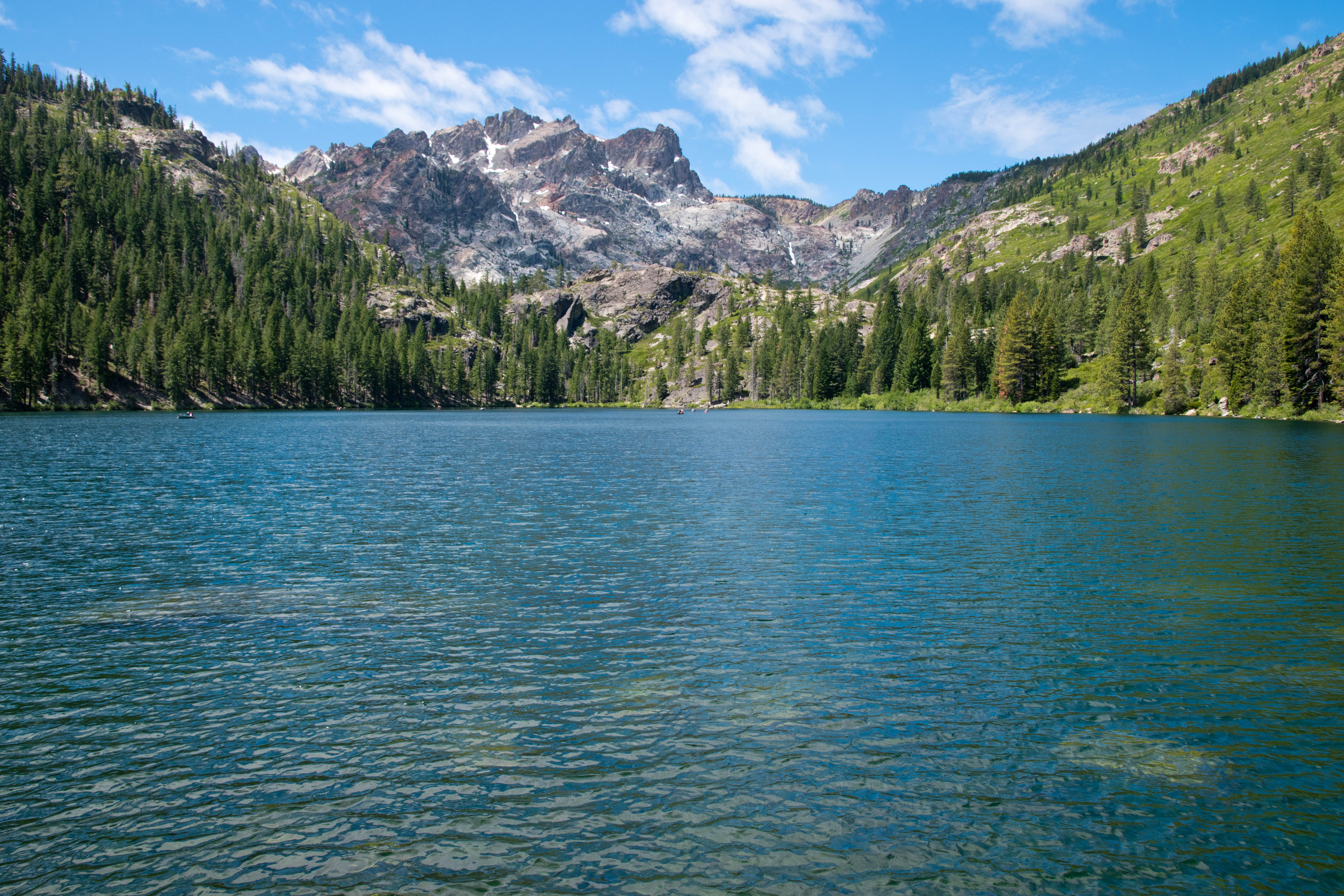
Continuing onwards, the trail- which was not always obvious here- followed cairns down the exposed rocky ledges here until reaching the shores of Columbine Lake near the lake’s outlet, about 6.5 miles from the trailhead. The best views of Columbine Lake were had on the opposite shore of the outlet, so I scrambled around the area and crossed the outlet stream until reaching a small, rocky peninsula that reached into the lake and delivered fantastic views of Sawtooth Peak and Needham Mountain rising above the lake’s inky waters. The scene was both beautiful and austere: the colors were extreme, with barren, white granite contrasting with the deep blues of the sky and water. The dramatic profiles of the peaks and ridges behind the lake made this a memorable view; this is certainly among the more beautiful places I’ve been in the Sierra Nevada.

Needham Mountain above Columbine Lake
Columbine Lake
Columbine Lake
Oddly enough, Columbine Lake- despite being over Sawtooth Pass- is actually in the Kaweah River watershed rather than the Kern watershed, as it drains to the north through Cyclamen and Spring Lakes and eventually into the Middle Fork Kaweah. The low ridge on the eastern side of the lake represents the true watershed divide, but after such an exhausting journey I was in no mood to explore further.

On the return trip, I had to make another arduous ascent back to Sawtooth Pass before descending down the precariously steep path to Lower Monarch Lake; from there, the smoother trail made things straightforward and I booked my way back to the trailhead so I could make it to Three Rivers in time for dinner.

Columbine Lake is an exceptional destination in the Sierra Nevada, but the hike and overall journey to get there is also exceptionally challenging. The hike is never crowded, although the trailhead can be quite popular and parking may overflow (I arrived prior to sunrise on a holiday weekend and the lot was already completely full). Most day hikers to the region will be content to visit Monarch Lakes, but those willing to put in far more effort will find one of the crown jewels of the Sierra Nevada.