Wednesday, September 28, 2022

Watkins Glen

Rainbow Falls and Triple Cascades
2 miles loop, 450 feet elevation gain
Difficulty: Easy-moderate
Access: Paved road to trailhead, New York State Park fee or Empire Pass required

An intimate sandstone gorge and graceful waterfalls make Watkins Glen State Park one of the most scenic and fantastic landscapes of New York State’s Finger Lakes region and a must-visit for anyone traveling through the region. The Gorge Trail- a beautifully built stone pathway through the canyon with rock staircases and arch bridges that harmonize with the nature around it- is the best way to see this state park, which lies just outside its namesake town at the southern end of Seneca Lake. The hike described here is a loop through the park that follows the Gorge Trail through the canyon’s highlights and then returns via a smoother path on the canyon’s north rim. There are plenty of stairs and the trail is usually wet and passes underneath falling water, so come with appropriate shoes and perhaps a rain jacket.

I visited Watkins Glen on an October fall foliage trip through upstate New York. I won’t provide detailed directions here, as it’s unclear where which direction most visitors would come from; the hike starts from the large parking lot at the mouth of the gorge, which is off of Route 14 (Franklin Street) just south of downtown in the town of Watkins Glen. There is a large parking lot at the park entrance that charges $10 a day for parking (there is nearby street parking in town as well, but much of that parking is limited to 2 hours or so). A large visitor center, restrooms, an outdoor relief map, and plentiful interpretive signage were just beyond the parking area at the mouth of the canyon.

There are two separate entrances to the park as well: one on the south rim of the gorge and another on the north side, at the far end of the gorge. The most straightforward way to access the gorge is still to enter from the main entrance; it’s also the most spectacular entrance. From the visitor center area, the Gorge Trail leads directly into the gorge, while the North Rim Trail leads up to the north rim of the canyon. At the time of my visit, the opening stretch of the Gorge Trail- which passes through a rock tunnel, crosses Sentry Bridge and travels underneath Cavern Cascade- was closed. Instead, we had to initially ascend the north rim via the North Rim Trail and then descended into the canyon and join the Gorge Trail at a point slightly farther into the canyon. While this caused us to miss the famed and scenic Cavern Cascade stretch of the gorge, we still got to see the rest of the gorge, including the famous Rainbow Falls segment in the heart of the gorge. It’s unclear if Sentry Bridge will be repaired in a reasonable time frame, so conditions on the trail may change by the time you visit; either way, it’s still worth visiting the rest of the gorge if you’re in the area.

We started our hike by walking along a paved path paralleling Glen Creek through the wider mouth of the gorge to the base of the Entrance Cascade, a waterfall that tumbled out of the canyon’s narrows into a broad bowl cut into the sandstone cliffs. The wide canyon mouth was the site of a sawmill in the early nineteenth century built by Samuel Watkins, the village’s namesake, who took advantage of the gorge’s abundant hydropower for industrial purposes. The natural beauty of the gorge was later recognized and tourism in the area developed by the late nineteenth century, although the current set of paths through the gorge did not exist until the Civilian Conservation Corps built them following a massive flood on Glen Creek in the 1930s that destroyed most of the previous visitor infrastructure.

Entrance Cascade and Sentry Bridge
From the viewpoint at the base of the Entrance Cascade, the Gorge Trail continued into a tunnel; but this marked the closure point on the Gorge Trail, so we backtracked slightly to the beginning of the North Rim Trail, which led uphill via a wide staircase. Over the next 200 meters, the trail ascended 120 feet, quickly rising above the canyon mouth below and soon delivering some views out to the village of Watkins Glen and beyond to the low ridges of the Finger Lakes. For most visitors, this is the most physically strenuous stretch of the hike, as the stairs are relentless until the trail reaches the rim of gorge.

Village of Watkins Glen
Once on the north rim of the gorge, the trail flattened out a bit. At 0.4 miles from the trailhead, we came to Point Lookout, where we had a view down into the gorge; here, a connector trail left the North Rim Trail and descended into the gorge to join up with the Gorge Trail. We took this connector trail, which dropped us into the sculpted sandstone walls of the canyon and soon brought us to the Gorge Trail and the tumbling waters of Glen Creek. Upon meeting the Gorge Trail, we took the right fork to travel up the canyon.

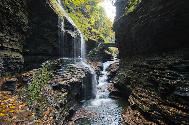
While not necessarily small, the gorge at Watkins Glen is a landscape that is beautiful on an intimate rather than a majestic scale. Here, wave-like canyon walls of eroded sandstone surrounded us, with Glen Creek happily burbling as it flowed down the canyon and autumn leaves floating down into the gorge from the hardwood canopy above. The trail itself blended in beautifully with this landscape: the Civilian Conservation Corps had built rustic rock walls and staircases that harmonized well with the sandstone and shale layers of the gorge.

Watkins Glen
Central Casccade
We followed the Gorge Trail over the next 0.6 miles until reaching the Mile Point Bridge, passing by the Lovers Lane turnoff along the way. The gorge was immensely scenic at first and only became more so as we went along, with the beauty of the gorge peaking after the junction with the Lovers Lane Trail, in a stretch that included Central Cascade, Rainbow Falls, and the Frowning Cliff. It’s advertised that there are 19 waterfalls in total in Watkins Glen; I’m a bit unsure of that number, but there are certainly over five significant drops in Glen Creek along the Gorge Trail in addition to Rainbow Falls, a tributary stream that feeds into the gorge by plunging straight down the shale and sandstone walls.

Central Cascade
Gorge above Central Cascade
Gorge below Rainbow Falls
Rainbow Falls and Triple Cascade
Behind Rainbow Falls
Watkins Glen has a complex and rich geological history. The plateaus of the Finger Lakes region are of a similar geological origin to the plateaus of West Virginia and Kentucky: they are all part of the broader Allegheny Plateau, an uplifted region of sedimentary layers. These sedimentary layers were laid down in the Paleozoic Era when a shallow sea covered much of what is now upstate New York. The resulting layers of shale and sandstone were uplifted directly during the Alleghenian Orogeny when the North American continent collided with the African plate to form Pangaea; this mountain-building event also created the more geologically complex crystalline Appalachians (the Blue Ridge, the Taconics, etc) to the east.

Frowning Cliff
In more recent geologic history, Ice Age glaciers scoured the Allegheny Plateau in the Finger Lakes region, eroding deep and wide valleys in the region that are now filled by those lakes. Smaller tributary glaciers fed into the large glacier carving out Seneca Lake’s valley, but these smaller glaciers did not leave gashes as deep as the larger glaciers; thus, after the ice retreated, hanging valleys formed above Seneca Lake. These hanging valleys created the elevation differential necessary for waterfalls to form; when Glen Creek flowed down one such hanging valley, it began cutting a gorge into the sedimentary layers of the Allegheny Plateau on its way down to Seneca Lake, creating the Watkins Glen that you see today.
 
Pluto Falls
Frowning Cliff
At a mile from the trailhead, we came to the appropriately named Mile Point Bridge, where there was a four-way junction in the trail. The Gorge Trail continued ahead, but connector trails split off to either side here, leading to the South Rim Trail and the Indian Trail. While there was about a half mile of canyon left between here and the upper entrance to the park, we chose to end our journey through the gorge here, partly because the gorge was less impressive upstream of the bridge and partly because we had spent so much time enjoying Rainbow Falls and Central Cascade that it was getting late. We took the connector for the Indian Trail to start heading back: this trail carried us uphill through some staircases to the top of the gorge’s north rim, where we joined up with the Indian Trail and turned right to start heading back towards the trailhead.

Mile Point Bridge
The Indian Trail descended steadily along the canyon’s north rim; while the trail generally stayed slightly back from the rim, a few spur staircases on the south side of the trail led to viewpoints overlooking Rainbow Falls and Central Cascade. At one point, the Indian Trail came to an unmarked junction: we took the right fork here to stay along the rim of the gorge (the left fork led to a nearby cemetery). At 1.5 miles into the hike, after a particularly steep stretch of descent, the Indian Trail came to a multi-way trail junction with the Lovers Lane Trail and a suspension bridge spanning the gorge. We walked out onto the suspension bridge here to gaze 200 feet down into the gorge, then continued along the trail along the rim until reaching Point Lookout, where we had begun our journey down into the gorge earlier. From Point Lookout, we followed the North Rim Trail downhill to the visitor center to finish this gorgeous hike.

Watkins Glen is a true highlight of the Finger Lakes region. Is it popular and crowded? Yes. But where else are you going to see such a spectacular interplay of sandstone and falling water? Avoid peak tourist times if you want to avoid crowds, but don’t miss this absolutely gorge-ous hike.

Wednesday, September 21, 2022

Kaaterskill Falls

Kaaterskill Falls
1.6 miles round trip, 400 feet elevation gain
Difficulty: Easy-moderate
Access: Good gravel road to trailhead, no entrance fee required

Wild and scenic, the two-tiered Kaaterskill Falls- the tallest waterfall in the state of New York with a 260 foot drop- has enchanted visitors for centuries, inspiring paintings by Thomas Cole and writings by Washington Irving. Near the popular North South Lake recreation area in the Catskill Mountains, the base of the falls can be accessed by a short but steep hike with lots of stairs from the Laurel House Trailhead. Uphill-averse visitors can still see the falls from above via a short hike to an overlook, although the view from the base of the falls is far mightier and satisfying. This is one of the highlights of New York’s Catskill Mountains but it’s no secret: expect to share this wonder with hundreds of other hikers on nice weekend days.

A word of warning: as with almost all waterfalls, the terrain around Kaaterskill Falls can be treacherous due to cliffs, slippery rocks, and fast-moving water. Stay on trail and don’t do stupid things.

I hiked Kaaterskill Falls during a fall foliage trip through the Catskills with Anna and my parents in mid-October. The waterfall is about two to three hours driving from the New York metro area, depending on where you leave from; we took I-87 (the New York Thruway) north to exit 20 at Saugerties, turned left at the exit ramp onto Route 212 west just briefly and turned right onto Route 32 north, following it 6 miles to a fork between Route 32 and Route 32A. At the fork, we stayed to the left to take Route 32A, which brought us into the village of Palenville. When Route 32A merged with Route 23A, we took the left fork to follow Route 23A west into the Kaaterskill Clove (the canyon of Kaaterskill Creek). Route 23A winded through the canyon and ascended to the village of Haines Falls; once in town, we followed the signs for North South Lake and turned right onto North Lake Road. We followed North Lake Road two miles east to the signed turnoff on the right for Laurel House Road and Kaaterskill Falls. Laurel House Road was a bumpy paved road that headed briefly downhill to a large gravel parking lot. Although the parking area is large, Kaaterskill Falls is immensely popular and the lot is frequently full; we waited about 10 minutes to be able to pull into the lot and find a parking spot on a sunny October holiday Monday.

The trail to Kaaterskill Falls departed from the southeast corner of the parking lot. While the hike described here is the full hike to the base of the lower falls, there are three potential final destinations for hikers, depending on how much they wish to exert themselves: the short, easy half-mile round trip to the falls overlook and the viewpoints at the base of the upper and lower falls, both of which involve long staircase ascents on the return hike.

Initially, the trail was wide with a gentle downhill grade and a comfortable trail tread as it began descending through the forest from the Laurel House Trailhead. Arriving in mid-October, we had come near peak fall color and so we enjoyed the yellow and red foliage around us shining in the afternoon lighting. After just 0.2 miles of hiking, as the trail approached a bridge on Kaaterskill Creek, we came to the turnoff for the falls overlook. On our inbound hike, we checked out the overlook, taking the short spur trail downhill through a switchback to reach the wooden viewing platform. The view at the overlook was decent: we could see the upper falls dropping into the cliff-lined gorge below and there was also a nice view to Kaaterskill High Peak across Kaaterskill Clove. However, this view was far more subdued than the view we caught later from the base of the falls and lacked the grandeur that the lower viewpoints delivered. This overlook is easily reached by most visitors and while it still involves a bit of elevation change, the round trip from here to the parking lot is never steep and the trail is always well maintained.

Kaaterskill Falls from the overlook
View of the Catskills from the waterfall overlook
Returning along the overlook spur trail to the main trail, we turned right onto the main trail and crossed a bridge over Kaaterskill Creek. The creek was pretty, tumbling down a rocky and wide (by Appalachian standards) streambed through the brilliantly lit forest of autumn hardwoods.

Kaaterskill Creek
On the far side of the bridge, we came to a trail junction with the Escarpment Trail, where we took the right fork, which led towards the spur trail to Kaaterskill Falls. The wide, easy-hiking trail ended here, transitioning to a much rockier path that briefly ascended for an eighth of a mile to reach a junction with the Kaaterskill Falls Trail. We followed the Kaaterskill Falls Trail as it branched off to the right from the Escarpment Trail and began descending, first gradually and then more steeply, into the gorge below. The beautiful fall foliage canopy and bountiful mushrooms fruiting in the understory made the descent down some occasional stone steps quite enjoyable.

Mushrooms
Fall foliage
The trail turned right for a steeper final descent into the gorge, dropping down a set of staircases to reach a fork between the trails leading to the bases of the upper and lower falls. 

Staircase on the descent to the base of the falls
We took the right fork initially: this trail followed a sandstone ledge, clinging to the top of a cliff above the lower falls. The trail here was muddy and a bit slippery due to mist coming from the falls, so luckily a chain fence provided some support and protection. The trail ended on a sandstone ledge at the edge of a pool directly below the leaping, taller drop of the upper falls. The upper falls is a 180 foot free fall, which makes it just taller than Niagara Falls and the second tallest single drop in the state of New York, after Taughannock Falls near Ithaca.

Airy upper drop of Kaaterskill Falls
Thomas Cole, the painter who founded the Hudson River School (the first major landscape painting movement in the United States), painted Kaaterskill Falls multiple times, including once climbing to the rocky alcove behind the upper falls to paint that scene. Fellow painter Asher Durand’s Kindred Spirits- a staple of art history textbooks- featured the falls as well. However, it was writer Washington Irving who first drew the attention of these European American artists to the area: he described the wildness of the falls vividly in Rip Van Winkle. Publicity from Irving and Cole eventually made Kaaterskill Falls a major tourist attraction in the later nineteenth century; the Laurel House, a large hotel, was built at the current trailhead to welcome tourists from New York City. By the mid-twentieth century, tourist attention had moved to other sights out West and Laurel House was torn down.

During our visit, water flow in Kaaterskill Creek was sufficient to make the waterfall quite impressive. However, in dry years (or even dry times of year), the waterfall may shrink to a trickle; I advise you to time your visit appropriately and check trail reports or river gauges in the area to get an idea of what to expect if you are set on seeing the falls in higher flow.

We also had lovely views from here of the steep, tree-lined walls of Kaaterskill Clove.

Forested Kaaterskill Clove
Returning to the main trail, we continued downhill on the long staircase, which ended at the base of the lower falls. From there, we made our way across some rocks to reach the banks of Kaaterskill Creek just below the lower falls. Here, we could see both drops of Kaaterskill Falls, an exceptionally scenic two-tier shape that almost reminded me of Yosemite Falls. This was the busiest spot on the hike; as there’s only a small area from which one can see the falls fully, expect things to be a bit crowded. After enjoying the views here, we retraced our steps and ascended the staircases out of the gorge to return to the trailhead.

View from the base of the lower drop of Kaaterskill Falls
This was a great short hike to one of the more impressive waterfalls on the East Coast. The only real drawback to this hike is the crowds: the beauty of the falls is well known and the hike is short, so this is a popular spot. While there’s enough room on the hike for people to spread out a bit (or at least to avoid lengthy queuing at popular viewpoints), the trailhead parking for this hike is likely to be overcapacity on nice weekends.

Wednesday, September 14, 2022

Giant Ledge

Fall colors of the Catskills from Giant Ledge
3 miles round trip, 1000 feet elevation gain
Difficulty: Moderate
Access: Paved road to trailhead, no fee required

The sweeping views of the high peaks of the Catskills makes Giant Ledge one of the most popular summit hikes in New York State's Catskill Park. The hike delivers panoramic vistas of the range's most spectacular mountains while requiring a relatively mild effort, by Catskill standards; however, this trail still involves a good amount of uphill and has multiple stretches that are very rocky, so novice hikers should understand that although this is an easier wilderness hike in the Catskills, it's still a wilderness hike in the Catskills.

I hiked up to Giant Ledge with Anna and my parents in mid-October during a fall color trip through the Catskills. The trailhead is about three hours driving from the New York metro area; we took I-87 (the New York Thruway) north to exit 19 for Kingston and Route 28, where we exited and then hopped onto Route 28 heading west from the exit roundabout. We followed Route 28 for about 30 miles west into the mountains to the village of Big Indian, where we turned left onto Oliverea Road (signs before the turn indicated the direction of the Giant Ledge trailhead). We then followed Oliverea Road south for 7 miles, passing through the village of Oliverea before ascending into the mountains and coming to the trailhead, which was at a sharp right bend in the road. Parking at the trailhead is unfortunately limited as there's no parking lot; you'll have to find room on the shoulder of Oliverea Road. We did not have trouble finding parking when we arrived on an autumn Tuesday, although I would certainly imagine that on nice weekends you might have to park some distance away from the trailhead and walk along the road to get to the start of the hike.

The hike started on the yellow marker Phoenicia East Branch Trail, which left Oliverea Road at the sharp bend in the road. The trail crossed over a small footbridge at the beginning and then immediately entered the Slide Mountain Wilderness, a wilderness preserve within Catskill Park that protects Slide Mountain, the highest peak in the range. The trail was initially fairly flat as we followed it through a beautiful autumn forest to a sturdy footbridge spanning a small stream. After crossing the stream, the trail began a steady ascent over the next three-quarters of a mile to reach the high ridge connecting Slide Mountain to Giant Ledge and Panther Mountain.

The Phoenicia East Branch Trail was quite rocky in places, especially during the steeper stretches of the ascent; wet soil from recent rains and copious fallen autumn leaves made the path a bit more treacherous at that time of year. However, there was plenty around the trail to entertain and reward us on what would otherwise have been a rocky uphill slog: the forest around us was at peak color and mushrooms were popping out all over the forest floor. This initial stretch of trail carries the majority of the hike's elevation gain, with just under 600 feet of uphill between the footbridge and the ridge.

Peak color
Autumn leaves of the Catskills
Mushrooms everywhere
Autumn mushrooms
At three-quarters of a mile from the trailhead, after a final push up a particularly rocky stretch, we arrived at the top of the ridge and came to an intersection with the Giant Ledge-Panther Mountain Trail, which was signed with blue markers. At this four-way intersection, we turned left and began following the blue-marked trail north along the ridge. This marked the halfway point of the hike, although at this point we had completed a majority of the hike's elevation gain. 

The half mile of trail that followed was fairly gentle as we followed a wide and fairly flat ridge that rose inperceptibly as we traveled north, although this stretch was surprisingly wet and muddy. The beautiful peak foliage in the forest around us made the rock-hopping through the mud a little more pleasant; it was interesting to me that we would find so much water at what is essentially the top of a mountain.

Beautiful foliage and flat hiking along the ridge of Panther Mountain
The Giant Ledge Trail became much steeper at one and a quarter miles into the hike. The final quarter mile of the hike was particularly rocky and ascended over 200 feet; many of the rock steps here were quite high and although most hikers can deal with this stretch without using their hands, some may find they have to engage in some mild rock scrambling here. We passed a small spur trail on the left that led to a spring at the start of this final ascent; otherwise, the trail was quite straightforward, heading continuously uphill through the rocks.

Rocky trail along the ridge on final ascent to Giant Ledge
The trail leveled out atop the long summit ridge of Giant Ledge, although it remained quite rocky. After a mile and a half of hiking from the trailhead, we came to an unmarked spur path to the right, which led briefly downhill and brought us out onto a rocky outcrop with a spectacular view: this was the first of the ledges at Giant Ledge and the destination of this hike.

There was a stunning 180-degree panorama of the Catskills east of Giant Ledge. Below us, the hardwood forests of the range were approaching peak color, although substantial swaths of green remained at lower elevations. The forested slopes of Giant Ledge eventually dropped into the gentle cradle of Woodland Valley, which was bound by Mount Pleasant on its far end. Beyond Mount Pleasant rose the imposing ridge formed by Indian Head Mountain, Twin Mountain, and Plateau Mountain, which are collectively known as the Devil's Path. An extremely challenging trail of that same name connects that chain of mountaintops. Beyond these peaks, the Catskills dropped away to the Hudson River Valley; we could not make out details in the Hudson River Valley clearly but could see the faraway peaks of the Taconics and the Berkshires- including what must have been Massachusetts' Mount Greylock- rising across the valley.

Remarkably, the view included no obvious signs of human habitation: no houses or roads or power lines were clearly visible, so this view gave the illusion that the range- which is actually quite populated- was some remote, untrammeled wilderness. 

Woodland Valley and the Greene County high peaks
Slide Mountain rose to the south as the high point of a ridge that included Wittenburg and Cornell Mountains. At 4190 feet, Slide Mountain is the highest point in the Catskills and the crowning summit of the Catskill High Peaks, which consists of the 35 Catskill peaks that exceed 3500 feet. 

Cornell and Slide Mountains from Giant Ledge
There are a total of five ledges at Giant Ledge, each a rocky outcrop facing east with similar views; hikers wishing for a quieter experience can continue past the first ledge to one of the later overlooks for a bit more solitude. Hikers who are done with the rocky Catskill terrain won't miss out on too much if they turn back after this first ledge, however. Intrepid hikers looking for a longer day hike can continue north up the ridge to the summit of Panther Mountain, roughly a 6 mile round trip journey, but most hikers will find Giant Ledge to be a sufficiently satisfying destination. 

Wednesday, September 7, 2022

Mount Baldy (Indiana Dunes)

Lake Michigan from the Mount Baldy dune
1.3 miles round trip, 150 feet elevation gain
Difficulty: Easy
Access: Paved road to trailhead, no entrance fee required

Mount Baldy is the only remaining living dune at Indiana Dunes National Park, making it a must-visit for hikers looking to see a large expanse of sand at this new national park. The short hike around this dune and down to a sandy beach along Lake Michigan is quite enjoyable, although it unfortunately does not visit the sandy summit of this dune, which has been off limits to visitors for years due to sand instability. Hiking the beach at Mount Baldy also gives visitors a chance to reflect on the fate of nearby Hoosier Slide, once the tallest of Indiana's dunes.

I hiked Mount Baldy during a day trip to Indiana Dunes National Park while visiting a good friend who was living in Chicago at the time. The day of our hike was a little on the humid side, with warm temperatures and overcast skies that threatened rain for much of the day. We drove in from Chicago, taking I-94 south and east into Indiana and leaving the interstate at exit 26A for Route 49. Upon exiting, we took Route 49 north for two miles and then made a left turn for the ramp to connect with US Route 12; we took the right fork at the bottom of the ramp to head east on US Route 12. We followed US 12 east for 8.5 miles until coming to a wide rightward bend in the road where the Mount Baldy turnoff was on the left side of the road; we turned left here and drove to the parking lot at the end of the road, where there was parking for at least 60 cars. There were flush toilets at this trailhead.

The back side of Mount Baldy abuts the parking lot. Mount Baldy is a living dune, and the wall of sand on its back end has gradually been shifting inland, swallowing trees in the forest and moving now to the edge of the current parking lot. The sand ramparts visible from the parking lot are perhaps the most vivid reminder of the power of the Indiana Dunes in the national park.

Mount Baldy dune swallowing trees
The trail to Mount Baldy beach started from the entrance of the parking lot. Initially paralleling the road, the trail ascended briefly via a boardwalk staircase before depositing us onto a broad, sandy trail cutting through the forest. The loose sand underfoot here was our main indication that the verdant hardwood forest around us was actually growing atop a sand dune. The trail descended for a stretch before beginning to climb up the forested shoulder of Mount Baldy. The former summit trail for Mount Baldy branched off to the right and led towards the main dune, but this trail is now off limits. In 2013, a 6-year old boy was swallowed by the dune while near the summit of Mount Baldy, launching a frantic three hour rescue effort that fortunately ended with a successful rescue. Park officials later found that decaying trees would leave holes in the interior of Mount Baldy, making the dune prone to collapse, and has since limited the top of the dune to guided tours.

Sandy trail down to the beach
The sandy trail then led uphill to the ridgeline of Mount Baldy dune. Here, the forest ended and a slope of sand opened up beneath us, running down to the shoreline of vast Lake Michigan. Even from this vantage point high above the lake, we could see no end to this inland freshwater sea- just a forever calm mirror reflecting the rays of sunshine piercing the grey pregnant clouds.

The descent down the dune to the lake was the most fun stretch of the hike: a few bounding strides brought us down to the sandy beach beneath Mount Baldy (Conversely, the ascent up this slope during the return was the most physically strenuous part of the hike, as I would backslide a step for every two steps forward). The beach at the base of the descent was quite crowded, with most visitors to Mount Baldy Beach enjoying the water within a hundred yards of where the trail met the beach.

Dune meets the beach at Mount Baldy
The trail ended here at the beach, but it was possible to wander freely along the beach in either direction; unfortunately, the body of the dune itself was cordoned off and inaccessible. We chose to head to the right (east) as the bulk of the dune lay to the east. As we hiked along the base of the towering piles of sand, the crowds evaporated and soon it was just us, the dunes, the lake, and the NIPSCO Michigan City coal-fired power plant in the distance.

Tall dunes and the NIPSCO Michigan City power plant
Lake Michigan is the largest lake entirely within the United States and the third largest of the Great Lakes by surface area (although if Lake Michigan and Lake Huron are considered one contiguous lake- which technically they are- the combined body of water would be the largest freshwater lake in the world by area). The Great Lakes were collectively formed by glacial erosion during periods of continental glaciation in the most recent Ice Ages. The glaciers that carved out Lake Michigan's basin also left a large amount of finely ground glacial sediment, which lake currents in more recent millenia deposited on the eastern shore of the lake. These deposits eventually formed the many sand dunes of Lake Michigan, which stretch from Sleeping Bear Dunes in the northern Lower Peninsula of Michigan to the Indiana Dunes and include notable features like the Saugatuck Dunes and the Silver Lake Dunes.

Mount Baldy dune and Lake Michigan
Although Mount Baldy is today the largest of the Indiana Dunes, the lakefront landscape of Lake Michigan was far different just over a century ago. Before the Port of Indiana and the cities of Gary and Michigan lined this lakeshore, there were massive dunes along the lakeshore, the tallest of which was Hoosier Slide, a 200 foot dune just east of where Mount Baldy stands today that rose above the growing settlement of Michigan City. However, as the Midwest turned into the industrial powerhouse of the world in the early twentieth century, demand grew for industrial facilities along the shores of Lake Michigan. Hoosier Slide- the biggest of all the Indiana Dunes and one of the state's greatest tourist attractions at the turn of the century- suffered an ignominious fate. Industrialists bought up the land where the dune stood and in the early 1900s the Hoosier Slide Sand Company began carting away the dune's sands by the railcar. The sand found of Hoosier Slide found its way into various industrial purposes; in one case, the Ball Brothers- famous even today for their Mason jars- discovered that the dune sand could be used to make beautifully blue tinted glass, so they participated in the desecration of the dune, gradually turning this soaring geological feature into their "Ball Blue" jars for home canning. By the 1920s, the tallest sand dune in Indiana had disappeared and the land it once occupied was acquired by NIPSCO at the end of that decade for a coal-fired power plant.

The state of Indiana established Indiana Dunes State Park in the 1925 to protect a small stretch of the dunefield as locals began to advocate for the preservation of the dunes. However, by the mid-century, the dunes were again under threat as plans were drawn up for the Port of Indiana at Gary. Advocates for preserving the dunes included the poet Carl Sandburg, who declared that the dunes were "eternity's signature" and that the dunes "are to the Midwest what the Grand Canyon is to Arizona." Senator Paul Douglas of Indiana lobbied John F. Kennedy on the matter of saving the dunes, leading to a compromise with a smaller footprint for the Port of Indiana and the establishment of Indiana Dunes National Lakeshore. The lakeshore was upgraded to a national park designation in 2019, a move championed by senators of both parties from Indiana.

Dunes along Lake Michigan
We ended our hike after walking about a third of a mile down the beach, reaching the eastern end of the Mount Baldy dune. We were within a stone's throw of the NIPSCO Michigan City power plant. In 2021, Indiana was still the nation's third largest consumer of coal power- understandable considering the role that energy-intensive heavy industry plays in the state's economy. However, NIPSCO already intends to decomission the Michigan City coal plant in the coming decade and wind power is growing quickly, so in the future there may not be a concrete cooling tower dominating the Lake Michigan skyline at Mount Baldy. Hoosier Slide is not coming back, but maybe there will be a place for waterborne sands to accumulate once again.

Mount Baldy dunes and Lake Michigan
Mount Baldy and the Indiana Dunes are not the showiest or flashiest of America's natural wonders, but they have a subtle beauty and are today preserved for us because of the dedication and love that previous generations of Midwesterners held for this landscape. If you're in Chicago or the state of Indiana during the warmer months, you should make your way out to these dunes. When you do, be sure to visit Mount Baldy to see this great dune meet the lake and to reflect on the site's complex history.