 |
| Glacier Peak rises above Image Lake |
31 miles round trip, 5000 feet elevation gain
Difficulty: Moderate-strenuous (this is a long, multi-night backpacking trip)
Access: Long, pothole-ridden gravel road to trailhead; Northwest Forest Pass required
Few Washington vistas are as iconic and memorable as that of Glacier Peak rising above the calm waters of Image Lake. Glacier Peak Wilderness is one of the largest roadless tracts in Washington State; this hike enters deep into this vast wilderness, visiting a remote lake perched high on the side of a meadow-filled alpine ridge. The hike to Image Lake is long and requires a multi-night backpacking commitment, but the rewards are ample enough to warrant the time investment demanded. The trail also visits Miners Ridge Lookout, a remote fire lookout with a stunning view of the North Cascades; I'll also discuss an option for visiting another nearby summit with even wider views. Even on a holiday weekend, I saw less than 50 people in 3 days while hiking to a spot renowned in Washington hiking circles.
I have had multiple negative experiences with mice in the Suiattle River area; I advise that you not leave food in the car to prevent mice incursions into your vehicle.
I hiked to Image Lake with three friends over a long holiday weekend at the end of summer. We chose to approach the hike as a three-day, two-night backpacking trip, using the first and third days to tackle the fairly flat 10-mile approach to the Miners Ridge Trail along the Suiattle River and visiting the lake and the lookout as a day hike from our camp on the second day. To reach the trailhead, we followed I-5 north to Arlington, then took Highway 530 east past Darrington to the Sauk River bridge; after crossing the bridge, we turned onto the Suiattle River Road and followed it to the end of the road at the Suiattle River Trailhead. The second half of the Suiattle River Road was unpaved, with many potholes and severe washboarding, which made for an unpleasant drive; however, the road is wide enough for pothole avoidance that any car should be able to reach the trailhead.
On our first day, we hiked 10 miles with 1200 feet of elevation gain, starting from the Suiattle River Trailhead and ending at a campsite right next to the junction between the Pacific Crest and Miners Ridge trails.
From the trailhead, we set off on the Suiattle River Trailhead, quickly passing the turnoff for the Sulphur Mountain Trail and the sign indicating our entrance into Glacier Peak Wilderness. The next three and a half miles of trail followed the milky Suiattle River, which drains the north side of Glacier Peak. Views of the river itself were just okay from the trail; the forest near the trail was typically fairly dense, prohibiting unobstructed views of the river. The old growth forest was quite impressive, with Douglas Fir and cedar trees measuring up to five feet in diameter standing tall near the river. The weather was blazing hot on the day of our hike, tempered only by occasional cool breezes when we crossed streams tumbling down the sides of the mountain towards the Suiattle River.
 |
| Waterfall on a creek along the Suiattle River Trail |
After about three miles of hiking, the trail began to climb away from the Suiattle River, staying at least a hundred feet or so above the river for the rest of the way. We passed a few campsites and crossed multiple streams en route to the suspension bridge over Canyon Creek 7 miles from the trailhead. At Canyon Creek, there were multiple campsites; late in the afternoon on a holiday weekend, there were still two unoccupied sites remaining.
 |
| Canyon Creek Bridge |
After crossing Canyon Creek Bridge, we soon came to a junction with the Pacific Crest Trail: the right fork led south to Mexico, the left headed north towards Canada. We took the left, continuing about another three miles to our campsite for the night.
 |
| PCT junction |
After starting on the PCT, we soon realized that the streams flowing down from Miners Ridge (the streams crossing the trail after the Canyon Creek bridge) were much less reliable than the streams earlier on; while there had been plenty of water along the first seven miles of the Suiattle River Trail, we found only two trickles of water in the three miles between the Canyon Creek bridge and the junction between the PCT and the Miners Ridge Trail. Luckily, the second of these two trickles was only a third of a mile away from our campsite for the night.
We found about four small campsites near the junction of the PCT and the Miners Ridge Trail; two were occupied on the holiday weekend by the time we arrived at dusk. We set up camp, ate dinner, and then rested to prepare for the next day's ascent to Image Lake. We noticed that mice were a big problem in the area: we heard the constant patter of their feet at the edges of the campsite as we ate dinner.
On our second day, we hiked 11 miles round trip with 3600 feet of elevation gain as we ascended to the Miners Ridge Lookout and Image Lake and then returned to camp.
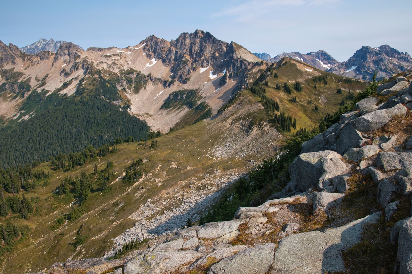
We started the second day by hiking up the Miners Ridge Trail, which was marked by a wooden sign indicating "Image Lake" just off of the PCT. The trail made a steady ascent uphill, crossing a stream and then climbing steadily via a series of long switchbacks. The switchbacks ended after about 2 miles of uphill trail from the PCT junction; shortly afterwards, we began catching our first views of Glacier Peak. Glacier Peak is the most remote of Washington's five volcanoes; unlike the other volcanoes, Glacier Peak is embedded deep within a range of other high peaks, making it stand out less from the surrounding landscape than Baker, Rainier, St. Helens, or Adams. Thus, Glacier was not initially named by George Vancouver during his reconaissance of the Northwest. Despite its name, the southern and western aspects of the mountain have fairly scant glacier cover; however, the northern face of Glacier Peak, which we saw from Miners Ridge, is heavily coated in flowing ice, making this one of the most beautiful faces of the mountain.
 |
| First view of Glacier Peak |
At 2.5 miles from the trailhead, we came to a trail junction between the Miners Ridge Trail and the trail that continued towards Suiattle Pass. A campsite lay just downhill of the junction; the trail straight led towards Suiattle Pass and the surely fantastic landscapes of Lyman Lake and the Entiats; however, those mountains would have to wait for another day, as we took the left fork to continue ascending up Miners Ridge.
Another two miles of constant climbing up switchbacks and through thickets of ripe huckleberries brought us out into the open meadows near the top of Miners Ridge. The long, 3000-foot climb we had endured was suddenly worth it as we broke out into open slopes with a commanding view of the Suiattle River Valley and lordly Glacier Peak. The twisting Suiattle River flowed below down a forested valley that appeared to have never seen the mark of man, complemented by a backdrop of imposing glaciated mountains.
 |
| View over the Suiattle River and Glacier Peak |
After over three hours of hiking, we arrived at the ridgeline of Miners Ridge, where views cut both directions. From the junction at the ridge, the trail to the left led slightly uphill to the Miners Ridge Lookout, while the one to the right led to Image Lake. We headed to the left to first visit the lookout, which was perched atop the meadow-draped slopes on a local highpoint of the ridge.
 |
| Miners Ridge Lookout |
In season, I imagine that the meadows atop Miners Ridge would be carpeted in blooming wildflowers; at the time of our hike, late in the season, I only spotted the moptop western anemone seed heads. As we hiked up, views to the east improved: we spotted Mount Plummer further down Miners Ridge and could see the hulking forms of Fortress, Chiwawa, and Dumbell Mountains across Suiattle Pass from Mount Plummer.
 |
| Trail along Miners Ridge with Mount Plummer, Chiwawa, and Fortress Mountain |
The lookout tower was only able to accommodate four people at a time and was staffed when we arrived, so we took turns visiting the top. We met Russ, a volunteer manning the lookout, who gave us a brief tour of the inside of the lookout. The lookout still had a fire finder, a tool that would allow fire watchers stationed at lookouts to easily pinpoint the direction of a smoke source on a map. We learned from Russ that phone lines once connected the lookouts to the outside world and that the individuals manning these lookouts would occasionally call people from other lookouts to socialize; at a lookout as remote as Miners Ridge, fire watchers would have led solitary lives. Before Image Lake became a popular destination, only a handful of humans would make it up to Miners Ridge each year.
 |
| Inside the lookout |
The views from the elevated lookout cabin were spectacular. To the west we could see back down the Suiattle River valley from which we had we come up; to the south, Glacier Peak was crowned in ice, ruling over a landscape without any noticeable traces of human presence. To the north, the barely discernable tips of Dome Peak and Sinister Peak poked out above the ridgeline of Bannock Mountain.
 |
| Glacier Peak towers above the Suiattle River when viewed from Miners Ridge Lookout |
Leaving the lookout, we returned to the junction for Image Lake and this time headed east along the ridge towards the lake. The trail stayed exposed on the south side of the ridge, delivering constant jawdropping views of the Suiattle Valley.
 |
| Fortress and Tenpeak hold court over the Suiattle River Valley |
 |
| Tenpeak Mountain and the Suiattle River |
A little less than a mile from the Miners Ridge Lookout junction, we came to another signed junction where the left fork led towards Horse Camp and Lady Camp and the right fork led towards hikers' campsites. We took the left fork, which would take us above the lake first. The trail ascended via a few switchbacks before bringing us into the lake basin, a hundred feet or so uphill from the lake itself. The trail began wrapping around the north end of the basin, delivering heart-melting views of Glacier Peak rising above the lake's sparkling waters.
 |
| Image Lake |
Just north of the lake, we found a trail that descended from the high trail down to the lakeshore. We descended to the lake through a hillside of huckleberry and heather, finding a spot on the lakeshore to rest for a nap and a swim.
 |
| Image Lake |
 |
| Image Lake |
We shared the whole lake with just a handful of other hikers. It wasn't always like this: Image Lake has had a long and controversial history. The lake has had to fend off threats from grazing sheep, hikers, and miners. The meadows on Miners Ridge, remote as they are, were once used for grazing; once this threat was mitigated, overzealous hikers from large outdoors groups like the Mountaineers and the Sierra Club began large expeditions to this utterly picturesque lake, gradually damaging the fragile habitat of the nearby meadows. Later restrictions on group size and where groups could camp (no camping is allowed on the lakeshore) helped the environment recover. A final threat came in 1988, when the Kennecott Copper tried to obtain permission to mine copper close to the lake. Strong opposition from environmentalists helped save the lake.
 |
| Image Lake |
The area around the lake was rich with huckleberries; our group spent a good amount of time picking and snacking on the nearby berries.
 |
| Huckleberries |
Having made it to the lake, I wanted to venture a little further up to a nearby highpoint on Miners Ridge. My friends were reluctant to leave the lakeshore, so I headed up to the top of nearby Peak 6758 alone; visiting this peak adds about 2 miles round trip and 700 feet of elevation gain to this hike.
To reach Peak 6758, I headed east along the trail from Image Lake to a junction with a high trail at a ridge; I took this trail northwest, following the slopes of the basin high above Image Lake. Western anemone seed heads lined the slope as I ascended gently along this trail with great views of Image Lake below.
 |
| Western anemone-covered slopes of Miners Ridge |
The trail led up to a saddle between Peak 6758 and the Mount Plummer ridgeline. The views at this saddle were good: an open meadow lay below and the summits of Dome and Sinister Peaks were now easily recognizable. From here, the trail descended down the north side of the peak, heading off towards Canyon Lake. I left the trail here, instead scrambling up Miners Ridge to the west.
 |
| View north from the saddle |
There was a small social path leading up from the saddle to the top of Peak 6758. I encountered a bit of Class 2 scrambling along the way but there was nothing terrible and I was at the summit about 10 minutes after leaving the saddle.
The views atop Peak 6758 were similar to those from the Miners Ridge Lookout, except better. The summit provided an overhead view of Image Lake and Glacier Peak, but also brought in views of a whole set of new mountains. Glaciers were visible on jagged Dome and Sinister to the north, while Canyon Lake was visible at the base of Bannock Mountain. To the west, I spotted the summits of Sloan, Pugh, and White Chuck- the Mountain Loop giants- poking above the ridgelines above the Suiattle Valley. Three Fingers was also visible, as was the Miners Ridge Lookout itself, which now seemed far below. To the northwest, the very tops of both Mount Baker and Mount Shuksan were visible. To the east, the panorama of Plummer, Dumbell, Chiwawa, and Fortress was now joined by Bonanza, the tallest non-volcanic peak in Washington State and one of the most difficult of Washington's highest peaks to spot.
 |
| Bonanza, Plummer, Dumbell, Chiwawa, Fortress: 4 of these are among Washington's 100 tallest |
 |
| Dome Peak, Sinister Peak, Bannock Mountain, and Canyon Lake |
 |
| Mount Pugh rises in the back with Miners Ridge Lookout in the foreground |
 |
| View of Image Lake from Peak 6758 |
 |
| Mount Baker and Mount Shuksan were barely visible from Peak 6758 |
After making my way back down to the lake, my friends and I moseyed our way back to the Miners Ridge Lookout junction, enjoying the berries and the views along the way; we then made quick work of the descent back to our campsite and enjoyed an excessively sodium-heavy dinner.
On our third and last day, we hiked 10 miles and climbed 200 feet on our way back to the trailhead. While the return trip was mostly downhill, we ran into a few short uphill segments. We hiked back at a quick pace under hazy skies filled with smoke coming from the Chetco Bar fire in Oregon and the just-initiated Eagle Creek fire that had begun ravaging the Columbia River Gorge. We made just one long stop to observe the work of carpenter ants carving a home into a tree. The work of ants chewing away at the tree and scurrying out with bits of sawdust was audible, which was an extraordinary experience. We spotted ants with varying amounts of work ethic: a few conscientious ants carried their sawdust from the entrance of the nest down to the base of the tree, dropped off their load, and returned to work further; other ants would simply chuck their sawdust particules out of small windows further up the tree.
 |
| Carpenter ants and the sawdust they deposit |
We returned to the trailhead to find that mice had partied in the car all weekend while we were hiking: the bag of Hawaiian chips that we had left in the car as our return treat had turned into mouse food. It was an unfortunate ending to an otherwise excellent trip; after dusting out the mouse droppings from the car, we made up for the lost Hawaiian chips with jalapeno poppers from the prepared foods section at the Darrington IGA.


Great write-up. Loved the little details. I am considering this as a solo backpack in a few weeks.
ReplyDelete