 |
| The High Peaks of Pinnacles National Park |
6 miles loop, 1450 feet elevation gain
Difficulty: Moderate; rock scrambling in slightly exposed areas
Access: Paved road to trailhead, Pinnacles National Park entrance fee required
Pinnacles National Park preserves a collection of rock spires in California's Coast Ranges. The Condor Gulch-High Peaks Loop is perhaps the best known and most intimate way of experiencing these odd rocks, offering a scramble route through the heart of the formations. The hike delivers a variety of small delights: rock gargoyles, chaparral landscape, talus caves, and a lake. This is a good place to spot the rare California Condor.
Visitors should be prepared for rock scrambling and ascents and descents on narrow rock staircases with mild exposure. Hikers planning on visiting Bear Gulch Cave should be sure to bring a flashlight as well.
I've hiked the Condor Gulch-High Peaks Loop twice, both times while visiting a good friend who lives in the San Francisco Bay Area. While the first visit was a day trip, the second hike was a camping trip arranged after an aborted attempt to ascend the Four Mile Trail to Glacier Point in March due to snow. From San Jose, we followed US 101 south to Gilroy and then took Highway 25 east through Hollister and then south to the entrance of Pinnacles National Park. Following the Pinnacles Highway into the national park, we passed the visitor center and continued all the way to the large parking area at Bear Gulch. We parked at the Bear Gulch Day Use area. While the park seemed much quieter during my March 2014 trip, by March 2018 visitation to the park was apparently skyrocketing and a shuttle system had been implemented to ease congestion and parking problems at trailheads.
We started our hike by heading up the Condor Gulch Trail. The trail began an immediate ascent and the park's namesake pinnacles were soon visible above us. As the trail climbed through well-graded switchbacks, more and more rock spires entered our field of view. About a mile into the hike, an overlook to the left of the trail provided a view from atop a cliff over the rocky gulch.
 |
| Pinnacles from the Condor Gulch Trail |
Past the overlook, the trail wrapped around the side of the mountain and then came out atop a ridge. From this ridge, there were beautiful and open views of the Pinnacles High Peaks and of the many ridges defining the California Coast Ranges.
Hiking high along the ridge above Condor Gulch, we spotted not one or two but three of the canyon's namesake animals. Three California Condors, the largest land birds on the continent, soared overhead. These vultures with 10-foot wingspans were hunted to extinction in the wild during the twentieth century, but are today making a comeback due to an extraordinary effort to save this critically endangered species. In 1987, the total population of California Condors numbered just 22, all in captivity, but through an ambitious conservation program, captive bred populations of condors were raised and then released back into the wild. Today there are around 300 wild California Condors; the three we saw at Pinnacles was fully one percent of the species' total wild population.
 |
| California Condor |
The Condor Gulch Trail ended at a junction with the High Peaks Trail atop a lofty ridge. At this junction, we took the left fork to head west towards the High Peaks. Views now expanded to the north: the peculiar, almost grotesque shape of the Balconies rose to north. As we followed the ridge west, the density of pinnacles around the trail itself rose: soon we were surrounded by a menagerie of breccia gargoyles.
 |
| The Balconies |
A half mile along the High Peaks Trail, we came to the junction with the Tunnel Trail, which headed downhill towards the trailheads on the western side of the park and provided a bypass for the trickier terrain of the High Peaks Trail. We stayed on the High Peaks Trail here, opting for the rock scramble/staircases through the most spectacular landforms of the park.
Park literature advises that the High Peaks Trail is steep and narrow; what this means is that the trail ascends and descends a number of high angle rock staircase and ladders and squeezes along rock ledges at spots. Mild rock scrambling is necessary at times and the trail may pose a problem for those with a fear of heights, but dangers are minimal for careful hikers as the National Park Service has installed metal railings along most exposed stretches of trail. While the total length of trail between the Tunnel Trail junction and the Juniper Canyon Trail junction is 0.7 miles, only a couple hundred meters of hiking during this stretch are actually more difficult.
 |
| Ladder portion of the High Peaks Trail |
The rewards of hiking through this rougher terrain (if you are not someone who finds rock scrambles to be an inherently rewarding activity) are the close-up and dramatic views of the heart of the Pinnacles. These stone towers of andesite and breccia were formed by volcanic activity of Neenach Volcano some 23 million years ago. The volcano formed at the plate boundaries of the Pacific and North American plates; while the other remnants of Neenach Volcano are near Lancaster in Southern California, the Pinnacles have moved halfway up the state via strike-slip motion along the San Andreas Fault.
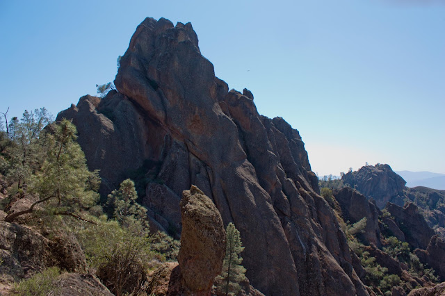 |
| The High Peaks of Pinnacles |
Part of the way through the High Peaks scramble, we met a few rangers who were using radio trackers to check in on the status of nearby condors.
At the end of the High Peaks scramble, the trail came to a junction with the Juniper Canyon Trail at a saddle. From here, a social path led uphill to a nearby rocky high point, which delivered one of the most impressive overviews of the Pinnacles.
 |
| View towards Chalone Peak |
Leaving the saddle, we continued on the High Peaks Trail as we began to descend towards Bear Gulch. The trail switchbacked as it dropped quickly amongst the spires; at points, the landscape was so rocky and steep that the trail passed through short tunnels cut in the rock formations.
 |
| Rock tunnel in the descent from the High Peaks Trail |
As the descent began leveling out, we came to the junction with the Rim Trail. Here, we took the right fork and followed the Rim Trail down towards Bear Gulch Reservoir. The trail cut across the chaparral slopes of a hill until coming to the rim of Bear Gulch. Here, Bear Gulch was very narrow- just meters wide between the sheer rock walls that bounded it on either side.
 |
| Bear Gulch |
The Rim Trail ended at Bear Gulch Reservoir. Chalone Peak and a variety of rocky pillars rose above the small dam and lake, which seemed quite natural in the chaparral landscape. We chose to have lunch here, following the trail towards Chalone Peak along the lakeside away from the dam briefly to find a quiet spot to ourselves. As we were now quite close to the road again, the rocky outcrops along the lakeshore near the dam were busy with visitors.
 |
| Bear Gulch Reservoir |
There are two routes back to the Bear Gulch Trailhead from the reservoir: the Moses Spring Trail stays above ground but is often the only option when the Bear Gulch Cave is closed. We decided to return through the Bear Gulch Cave, which is closed seasonally for the bats that inhabit it- check the status of the cave on the National Park Service website before you go. The cave is generally closed during the early summer (May-July) and may close at other times if the bats are not hibernating.
From the dam, a staircase leads down into Bear Gulch Cave. The cave is talus cave- very different in feel and in geological past from the more familiar and famous karst caves of Carlsbad Caverns or in the Shenandoah Valley. The cave is simply the bottom of the Bear Gulch- massive rocks have lodged into the narrow canyon walls over time, forming a roof over the canyon itself. A stream flows through the cave. At first, the trail passed by skylights created by gaps in the talus above, but it soon descended into nearly total darkness in the heart of the cave- bring a flashlight! The trail followed a metal grating walkway at points as it descended, passing small cave waterfalls and small pools in the darkness.
 |
| Bear Gulch Cave |
Emerging from the other side of the cave, we walked out into the greenery lining the creek in Bear Gulch. We followed the trail gently downhill, joining the Moses Spring Trail and taking it back down to the road. A final stretch of trail parallel to the road brought us back to where we parked the car at Bear Gulch Day Use Area.


No comments:
Post a Comment