 |
| Cerro Garcia rising over Lago de Chapala |
6.5 km round trip, 700 meters elevation gain
Difficulty: Moderate-strenuous
Access: Trailhead off street in Ajijic, no parking lot
Tres Cruces, a spot high on the slopes of the Sierra de San Juan Cosala, is an excellent place to gain a bird's-eye view of Lago de Chapala, Mexico's largest freshwater lake. Located in the state of Jalisco just south of Guadalajara, Lago de Chapala is a large and beautiful lake rimmed by forested mountains, farms, and small towns. The town of Ajijic- popular with US expats- is one of the prettiest towns along the lake and the starting point for this hike, which climbs high onto the ridges of La Chupinaya above the town. The trail is largely unmarked and is very steep at times, making it a bit of a challenge, but the views over the lake are incredible.
I did this hike during an early March trip to Mexico City and Guadalajara, the last of my post-graduation travels before the rapidly spreading Covid-19 pandemic grounded me for the time being. I did the hike during an afternoon trip down to Lago de Chapala from Guadalajara and unfortunately I did not complete the hike, which reaches the actual three crosses atop the crest of the Sierra de San Juan Cosala and then continues to the summit of La Chupinaya, the highest peak in the range. However, my turnaround point was less than 100 meters of elevation gain from the Three Crosses and the views were already good enough from that point that I can vouch for this hike's excellent scenery. If you decide to do this hike, bring some hiking poles as it's quite steep; also, bring a map or have some sort of offline navigational tool at hand as there are almost no trail markers here. Also note that this hike starts at a mile above sea level and that the weather here is hot, especially in the afternoon; bring plenty of water.
I took the bus to reach Ajijic from Guadalajara; if you don't have a car and you're less adventurous, you could of course Uber or take a cab, although it's important to note that there is limited Uber service at Lago de Chapala itself. Chapala Bus Lines operates out of the Central Vieja bus station in Guadalajara; they operate direct service to Ajijic on the hour for 120 pesos (as of March 2020), with the trip taking about an hour as well.
I hopped off the bus in the heart of Ajijic, at the intersection of the Chapala-Jocotopec Carretera and Colon near the Chapala Bus Lines station. The hike up to Tres Cruces started uphill to the north, but I decided to start my Ajijic exploration with a short walk along the lakeside first. I took the narrow streets of Colon downhill past the town plaza and church to the Ajijic Malecon, the waterfront. Along the way, it was apparent that Ajijic was popular with US tourists and expats- I saw signs in English for art shows and events. The Ajijic waterfront was indeed the advertised paradise I expected: a peaceful walkway along the lake with pretty mountain views and plenty of birds on the water. The lake was not particularly clean but still was pretty while reflecting that day's blue skies; I was lucky to have missed the smog that often covers Guadalajara and the lake.
 |
| Lago de Chapala from the Ajijic Malecon |
 |
| Sierra de San Juan Cosala rising above Lago de Chapala and its pelicans |
After enjoying the views along the water, I returned via Colon to the carretera, which I followed two blocks east to the Oxxo; here, I turned left and followed that road (Galeana) uphill as it turned into a cobblestone road. As the road made a sharp right turn at the edge of the town, I found the trailhead leading off into the woods on the left side of the road, with a sign indicating that it was the trail to the chapel and the Three Crosses.
The trail climbed a bit and then leveled out as it skirted the back of the residences at the edge of town; through the trees, I had some views down to Ajijic's center and the water beyond that. After 200 meters, I came to an unmarked junction; here, I took the sharp switchback that doubled back and began ascending, as the trail that continued straight simply descended to another trailhead.
The first portion of the hike ascended at a reasonable grade via switchbacks, which passed little shrines along the way representing the stations of the cross. The trail climbed about 100 meters in first half mile, with a few nice views of Ajijic and Lago de Chapala at breaks in the trees.
 |
| Ajijic on the shores of Lago de Chapala |
At a half mile in, I arrived at a small chapel that overlooked the lake, the first clear viewpoint of the hike. If you're looking for an easy hike, this is a good spot to turn back: you can already enjoy good views of the lake from here. A couple agave grew nearby, a reminder that nearby farms in Jalisco are the birthplace of tequila.
 |
| Chapel |
Past the chapel, the trail became substantially steeper, largely abandoning switchbacks in favor of tackling the ridge directly; the trail dispatched with about 180 meters of elevation gain in the next half kilometer before flattening out as it entered a clearing. There were some more nice views of the lake from here as well as the Sierra de San Juan Cosala to the west.
 |
| Lago de Chapala from lower viewpoint on the ridge |
At the top of the clearing, there was an unmarked four-way junction; I took the left fork to continue towards the Three Crosses. This trail flattened out a bit and began following the contours of the hill, crossing over a fence before descending slightly to a saddle. At the saddle, there was a clear view of the crest of the Sierra de San Juan Cosala rising ahead; La Chupinaya, the highest peak of the range, towered to the northwest. There was another unmarked four-way trail junction here: the trails to the left and right led down into the drainages on either side and eventually led back down to Ajijic, while only the trail directly ahead continued towards the Three Crosses.
 |
| Sierra de San Juan Cosala |
Leaving the saddle, I started the most extended and brutal climb of the hike. The uphill was direct and unrelenting, climbing about 350 meters in the next 1.5 km. The shade from the trees helped me cool down a bit but I still found the heat and sun to be oppressive as I worked my way uphill. My efforts were finally rewarded with a nice east-facing viewpoint that provided a high view of Lago de Chapala. I could see to the town of Chapala- more popular with domestic tourists- and all the way out to the mountains rising above the eastern end of the lake, quite impressive as Lago de Chapala is about 75 km in length. Tiny cones dotted the horizon- cinder cones that form the Michoacan Guanajuato Volcanic Field, a large region of volcanism that includes over 1000 volcanoes, mostly small cinder cones. This volcanic field includes Paricutin- not visible from this hike- which famously erupted out of a farmer's cornfield in 1943 and formed a 400-meter tall cone after a nine-year eruption.
 |
| Lago de Chapala and Ajijic |
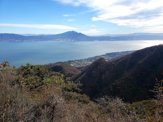
After enjoying this viewpoint, I continued along the trail, which remained extremely steep. Soon, views were more common: one stretch of the trail traversed an open slope with stunning views of the lake. The Sierra de San Juan Cosala crest still looked far away though, so I took another break at a rock that was still about 100 meters lower in elevation than the crest and Tres Cruces. Here, I had a magnificent view looking out over the lake. The town of Ajijic was below and Cerro Garcia rose on the opposite side of the lake.
 |
| Lago de Chapala from my turnaround point |
The high peak of La Chupinaya itself was visible to the west. Although this was never the intended destination of my hike, I've read that the summit provides awesome views, encompassing not only the lake but also the length of the forested Sierra de San Juan Cosala and the Guadalajara skyline to the north. Every July, Chupinaya is the site of an intense mountain race, as runners compete to complete the round trip from Ajijic Plaza to the top of Chupinaya on the mountain's and rocky trails.
 |
| La Chupinaya |
As I covered earlier, Lago de Chapala is the largest freshwater lake in Mexico; it's a popular tourist destination, especially for domestic tourists visiting Guadalajara. Besides being the largest lake in the country, the lake also lies along the longest river system wholy within Mexico- the Rio Lerma Santiago. The Rio Lerma originates in the high basin of Toluca, fed by the snows of Nevado de Toluca, before journeying across Central Mexico and flowing into Lago de Chapala. Lago de Chapala is then drained by the Rio Grande de Santiago, which plunges down El Salto- the Niagara of Mexico- before flowing past Guadalajara in the dramatic canyon of Barranca de Oblatos, emptying into the Pacific Ocean in the state of Nayarit. The waters of the Rio Lerma Santiago became extremely polluted in the last few decades as industry developed in Central Mexico and expanded with NAFTA; in fact, the waters of the river itself became toxic. In 2008, a boy who fell into the Rio Grande de Santiago near El Salto Falls died of arsenic poisoning shortly after exiting the water; polluted water and low flow in the Rio Grande de Santiago have turned tourist attention away from the once-popular El Salto Falls, once one of the most impressive waterfalls in Mexico. Clean-up efforts are underway today and I hope to be able to visit those falls on a future trip to Jalisco.
 |
| Lago de Chapala |
The trail continues a short distance and another 100 meters of uphill to reach the crest of the Sierra de San Juan Cosala and the Three Crosses, which purportedly feature excellent views over Lago de Chapala. Unfortunately, I turned around just short, having run out of time to finish: I had to return to Ajijic so that I could catch a bus to the Guadalajara Airport, as I was flying to Mexico City that evening. If you make it to the top- tell me what it's like! Even without having finished this hike, I found the scenery to be extremely enjoyable, so you should consider this hike if you're in Ajijic on a clear day.


No comments:
Post a Comment