 |
Grassy meadows on Bald Mountain
|
6 miles loop, 1600 feet elevation gain
Difficulty: Moderate
Access: Paved but narrow road to trailhead, Sugarloaf Ridge State Park entrance fee required
Bald Mountain is the crowning summit of Sugarloaf Ridge State Park, which preserves a slice of the Mayacamas Mountains in California’s Wine Country. Just a short drive from Sonoma or Santa Rosa, the hike to the top of Bald Mountain may not be anything close to a wilderness experience- after all, the trail up to the summit mostly follows a paved road- but the wide views over Wine Country, San Francisco Bay, and higher peaks to the north make this a worthwhile outing for locals. Winter and spring are the best times for this hike, when the grassy hillsides are green and skies are more likely to be clear.
The hiking loop described in this post starts from the Robert Ferguson Observatory in Sugarloaf Ridge State Park and then follows the Lower Bald Mountain Trail and then the paved Bald Mountain Trail to the 2729-foot summit. On the return, I took the Gray Pine Trail back down into Sonoma Creek’s canyon, returning to the observatory along a stretch of the Meadow Trail.
I visited Sugarloaf Ridge State Park on a nice March weekend. As the park is halfway between Sonoma and Santa Rosa, hikers can access it by following Highway 12 from either city. Coming from the direction of San Francisco, I reached the trailhead by following US 101 north to Santa Rosa, taking exit 488B to follow Highway 12 east. To stay on Highway 12, I turned left at Farmers Lane when the freeway ended and followed it to the intersection with 4th Street, where I turned right to continue heading east. 4th Street became the Sonoma Highway, which I followed east out of the city into Sonoma Valley; just after passing Hamilton Vineyards on the left, I turned left onto Adobe Canyon Road and followed it up a narrow canyon into Sugarloaf Ridge State Park; the road became quite windy and narrow as it entered the park. After paying the state park fee at the entrance kiosk, I drove until just before the end of the road, parking at a large lot at a wide left turn in the road, about a hundred meters down the road from the Robert Ferguson Observatory. This lot has room for at least 40 cars; there is a second parking lot closer to the visitor center near the entrance kiosk, although that lot tends to fill faster.
I followed the road a hundred meters to the Robert Ferguson Observatory to start the hike. This is a rare community observatory, dedicated to allowing the public to explore the night sky rather than being the exclusive domain of academic astronomers. Named after a local astronomy enthusiast, the observatory’s 40-inch reflecting telescope is frequently open to the public for stargazing. One of the more unique astronomy-inclined installations near the observatory was a scale model of the Solar System, with the Sun at the observatory and the outer planets scattered along the Meadow Trail. I would get a closer experience with this Solar System model on the return leg of my hike.
From the observatory, I hopped on the Lower Bald Mountain Trail, a single-track path that headed northwest and uphill. I immediately passed a junction with a connector trail heading over to the Stern Trail and the visitor center; I stayed on the Lower Bald Mountain Trail through this junction and began ascending through a pretty grassy meadow with views of the peaks south of the canyon.
 |
Sugarloaf Ridge State Park
|
As the trail headed uphill, it reentered oak woodlands, passing through a beautiful stretch where the single-track trail cut through verdant grasses while winding amidst the trees. At 0.8 miles the Lower Bald Mountain Trail emerged into a burn scar left by the 2020 Glass Fire and shortly afterwards connected with the Bald Mountain Trail.
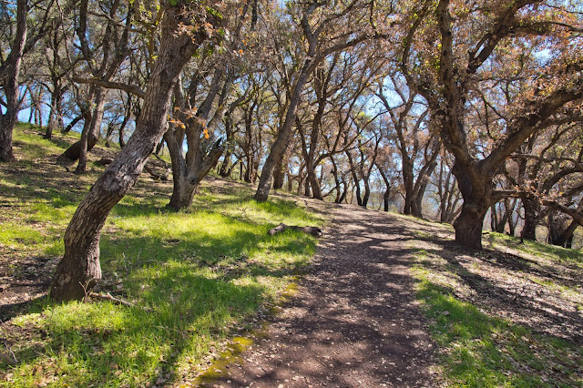 |
Trail through an oak forest
|
I turned right at the junction with the Bald Mountain Trail and followed this paved road uphill. If you’re looking for wild, the Bald Mountain Trail certainly isn’t it- it is a reasonably well-maintained paved road that is still used on occasion as a service road for accessing the communications towers atop Red Mountain. The Bald Mountain Trail initially passed through a scarred landscape of torched brush, but soon moved back into lush green meadows broken by patchy oak woodlands.
At 1.2 miles, the Bald Mountain Trail passed a junction with the Vista Trail, a single track trail that head off to the left across a beautifully grassy hillside. Shortly after passing the Vista Trail junction, the trail wrapped around a seasonal pond before continuing its ascent.
 |
Pond on the grassy slopes of Bald Mountain
|
The trail wrapped around the back side of Red Mountain as it climbed, passing a junction with the Red Mountain Trail at 1.8 miles. At 2.2 miles from the trailhead, I reached the saddle between the lower Red Mountain and the taller Bald Mountain, a massive grassy mound that now rose directly ahead of me. Here, the paved road ended; a sharp left fork in the road headed towards Red Mountain, while the main trail towards Bald Mountain transitioned to a good dirt road trace.
The Bald Mountain Trail began a final 0.4-mile push to the summit, ascending via some switchbacks through the open grassy slopes. Views really opened up at this point, with much of the landscape to the south visible behind the communications towers of Red Mountain. I could see as far as the Bay, the San Francisco Peninsula, and the skyline of San Francisco itself.
 |
View towards Mount Tam and the Bay
|
 |
Green, grassy slopes of Bald Mountain
|
At 2.5 miles, the trail made a clockwise rotation around the summit before reaching the wide high point of the mountain. A bench at the top of the 2729-foot mountain provided a nice spot to rest and enjoy the sweeping 360-degree panorama here. Napa and Sonoma Valleys lay on either side of Bald Mountain, with their fields of mustard flowers and vineyards giving a distinct pastoral look. The Mayacamas Mountains stretched to the north, with the summits of Mount St. Helena and Cobb Mountain clearly visible; the elusive Snow Mountain, still true to its name in March with a white coat, was faintly visible as well. To the south, I could see the Bay, the San Francisco skyline, Mount Tam, and Mount Diablo. Hood Mountain rose to the west above Sonoma Valley.
At 3.8 miles, the trail came to another junction, where the Gray Pine split from the Brushy Peaks Trail. While the Brushy Peaks Trail continued along the crest of the ridge, the Gray Pine Trail headed right and downhill here, following a minor ridge back down into the Sonoma Creek watershed. The trail descended steeply, dropping 950 feet over the next 1.2 miles as it traveled beneath a set of power lines.
 |
Views along the Gray Pine Trail
|
The Gray Pine Trail arrived at the bottom of the valley at 4.8 miles, crossing a small stream and then coming to an intersection with the Vista Trail. Heading down the valley for another 0.2 miles, I crossed Sonoma Creek and then joined up with the Meadow Trail at 5.1 miles; I took the right fork upon meeting the Meadow Trail to follow that trail back to the Observatory and the parking lot. The Meadow Trail was flat after an initial crossing of Sonoma Creek; it then traveled through meadows at the bottom of the canyon.
 |
Crossing Sonoma Creek
|
At 5.5 miles, I came to a plaque by the trail with a depiction of Saturn: this was one of the ten plaques that are part of the Sugarloaf Ridge State Park planet walk originating at the Robert Ferguson Observatory, which I had mentioned earlier. This scale model is at 1:2.4 billion and accurately represents both the relative sizes of the planets and the distances between them. Saturn could fit onto a sign here, but the planet was still a half mile from the observatory, so the immense scale of our Solar System really came across in this representation. After passing Jupiter and the Inner Planets while hiking along the meadow, I arrived back at the Robert Ferguson Observatory, completing the loop.
Bald Mountain is one of many pleasant peak hikes in the greater San Francisco Bay Area. In the Wine Country, its views are probably second only to those from Mount St. Helena; however, the paved road that ran almost to the top of the mountain detracted at least somewhat from my hiking experience. There were plenty of hikers on a sunny spring weekend day, enough to fill most of the parking spaces by the time I finished my hike in the early afternoon, but the far reaches of the hike- especially on the Gray Pine Trail- were pretty quiet.


No comments:
Post a Comment