 |
Mount Haeckel rises above the outlet of Hungry Packer Lake
|
13 miles round trip, 2700 feet elevation gain
Difficulty: Moderate-strenuous
Access: Paved road to trailhead, no fee required
The austere headwall of Mount Haeckel rising from the azure waters of Hungry Packer Lake may be the most astonishing scene of this lengthy day hike into Sabrina Basin in California’s Eastern Sierra Nevada, but it is only one of many striking views encountered along this superb alpine hike. This hike climbs from popular Lake Sabrina up to the shores of mountain-ringed Blue Lake, then wanders through the rocks, meadows, streams, and lakes of Sabrina Basin until finally reaching the alpine wonderland of Sailor Lake, Moonlight Falls, and Hungry Packer Lake, which are surely among the most beautiful locales in all of California. There is plenty of work needed to achieve these rewards: the hike is rocky, long, and fairly tough, but the views of the High Sierra along with the pretty intermediate destinations of Blue Lake and Dingleberry Lake make this a highly rewarding hike.
This is a harder hike than the net 2000 feet elevation change between Lake Sabrina and Hungry Packer Lake might suggest. For one, the trail between Blue Lake and Hungry Packer Lake is full of ups and downs, delivering an extra 600 feet of cumulative elevation gain on its way there and back through Sabrina Basin. Secondly, much of this hike is very rocky, especially the upper half of the climb to Blue Lake and the trail throughout Sabrina Basin. Thirdly, the whole hike is at high elevation (Hungry Packer Lake is at over 11000 feet above sea level), so altitude sickness can be a serious concern without proper acclimatization.
I hiked through Sabrina Basin to Hungry Packer Lake during a mid-July visit to the Bishop area. This was the perfect time to visit: snow from the previous winter was almost completely melted and wildflowers were at peak bloom in the alpine meadows. The only drawbacks were relatively hot weather, thunderstorms that struck high elevations during the afternoon at this time of year, and the omnipresence of mosquitoes near the lakes. Hiking poles, sunscreen, bug spray, a mosquito head net, and proper planning with knowledge of the weather forecast are all essential to doing this hike.
The High Sierra access behind Bishop is a long way from any major city: to reach this trailhead requires nearly 5 hours of driving from Los Angeles and over 6 hours of driving from the San Francisco Bay Area. Unless you approach on Highway 6 from Tonopah, you’ll inevitably have to arrive at Bishop on US 395; from downtown Bishop, at the junction of US Highway 395 and Highway 168, turn west onto Highway 168 and follow it out of town and uphill, continuing straight along this road and passing the turnoffs for South and North Lakes. After Highway 168 ends, the road continues as a narrower paved road and arrives at the Sabrina Basin Trailhead on the left side of the road just before the road reaches a bridge over Bishop Creek below the Lake Sabrina Dam. The trailhead is not clearly marked by any signage from the road, although at the start of the trail there is an informational placard telling hikers that they are hiking into the Sabrina Basin. There is parking for less than ten cars in the pullouts near the trailhead; if the parking here is already full when you arrive (likely if you aren’t arriving, like me, at 5 AM in the morning), you’ll have to continue another quarter mile along the road to the large day-use parking lot for Lake Sabrina, where there are plenty of parking spots and pit toilets; if so, you’ll also need to factor in an extra half mile round trip to this hike.
I headed up the trail from the Lake Sabrina trailhead, which started a gentle but steady ascent through the forest. At two hundred yards from the trailhead, the trail passed a connector path leading to the Lake Sabrina Dam and then made two quick, sharp switchbacks to climb above the level of the dam. At this point, the trail flattened out and headed south, following the east shore of Lake Sabrina. Although there was a good deal of mixed brush and trees near the trail, there were generally good views of Lake Sabrina along this stretch of trail. Jagged, snow-capped granite peaks formed the backdrop to the lake, giving promise to the High Sierra scenery that would come later in the hike.
 |
Lake Sabrina
|
At a mile into the hike, I started up along the main ascent of the hike: a 1300-foot ascent over two miles from Lake Sabrina to Blue Lake. The sun was just beginning to rise at this point, with alpenglow painting the peaks behind Lake Sabrina. A waterfall tumbled down from the high cliffs above the lake, marking the descent path of Middle Fork Bishop Creek from Sabrina Basin above to the reservoir below.
 |
Waterfall and granite peaks behind Lake Sabrina
|
The trail ascended steadily across an open, shrub-covered slope with wide views. Blooming wildflowers dotted the slope and I could see most of Lake Sabrina below me. At one and a quarter mile, the main trail passed a steep side trail to George Lake that peeled uphill to the left. Shortly after, the trail reentered forest and crossed over the cascading outlet stream from George Lake.
 |
| Cascade along a creek on the trail to Blue Lake |
The trail stuck to the forest after the stream crossing and continued on a relentless and aggressive uphill climb. The rocky trail made life a bit more challenging here as the trail ascended steadily via switchbacks. At 2 miles into the hike, I had a brief respite from the endless uphill as a few switchbacks along the trail swung out onto an open granite outcrop with spectacular views of Lake Sabrina below, red Mount Emerson rising above the North Fork Bishop Creek valley, and the backlit White Mountains in the distance across Owens Valley.
 |
| Overlooking Lake Sabrina, with Mount Emerson rising above |
The trail began heading further up the watershed at 2.2 miles, marking an end to the views of Lake Sabrina. The uphill didn't end, though, as the trail continued its rocky push towards Blue Lake. At 2.6 miles, the trail made a set of switchbacks through a tight, rocky ravine. In mid-July, this ravine was exploding with Sierra columbine, with a beautiful mix of yellow, purple, and pink variants- I'm not sure I've ever seen so much Sierra columbine in one place. While this was a quiet spot that lacked the grandeur of the granite peaks later in the hike, it was lovely and enjoyable to see such a spectacular show of columbine.
 |
| Sierra columbine in bloom |
 |
| Sierra columbine |
 |
| A riot of Sierra columbine |
At 2.8 miles, the trail leveled out and soon came to the shores of Blue Lake, the first of the many lakes I would visit that day in the Sabrina Basin. The trail arrived at the outlet of the lake and then crossed the outlet stream, following a route across granite slabs on the other side of the stream.
 |
| Outlet of Blue Lake |
The trail soon returned to the lakeshore at a spot with a much more open view of the entirety of Blue Lake. A great granite ridge that led back to the high peak of Mount Thompson rose imposingly above the lake, which had a sparkling blue color that lived up to its name.
 |
| Mount Thompson rises above Blue Lake |
The trail made a sharp right turn at this lakeside viewpoint and entered the forest. At just over 3 miles from the trailhead, I passed a junction with the trail to Donkey and Baboon Lakes; I took the right fork at this junction to head towards Dingleberry Lake. The trail traveled across a flat, forested bench for a few hundred meters after the junction before coming to an exposed talus slope. There were nice views down the valley of Middle Fork Bishop Creek as I crossed this exposed stretch of the trail.
At 3.6 miles, the trail turned back into the forest, passed a small pond and then came to a junction with the spur trail to Emerald Lakes. While the main trail to Dingleberry and Hungry Packer Lakes continued to the right, I took the side spur trail for fifty meters and then traveled followed a social path to the left to visit one of the string of lakes known as the Emerald Lakes. The trail to Emerald Lakes continued onward from here, but I found this lake to be a perfect, serene High Sierra scene, with a serrated granite summit rising directly above the grass-lined, tree-ringed, mirror-like lake.
 |
| One of the Emerald Lakes |
Returning to the main trail, I continued along my way towards Dingleberry and Hungry Packer Lakes. Over the next half mile, the trail undulated over hilly granite terrain that was interspersed with forests, until coming out atop a low granite ridge above Dingleberry Lake. This low ridge gave lovely views over Dingleberry Lake as well as the wall of High Sierra spires behind it, which now included Picture Peak and Mount Haeckel.
 |
| Overlooking Dingleberry Lake |
The trail followed the ridge briefly with its expansive views before descending through the forest and reaching the shoreline of Dingleberry Lake at 4.4 miles from the trailhead. As the trail reached the lake on its southern shore, I was not able to see Dingleberry Lake with a High Sierra backdrop from this angle; however, the view of lower granite peaks and pines on the opposite shore from here was still quite nice.
 |
| Dingleberry Lake |
Leaving the shores of Dingleberry Lake, traveled across a fairly flat landscape of granite interspersed with forest and came to a junction where the trail split between a stock and a hiker trail; as I was traveling on foot, I took the right fork. The hiker route brought me to the banks of Middle Fork Bishop Creek at 4.6 miles. In July, the creek was still fairly full, with a thirty-foot wide span that was crossed by a series of strategically-placed rocks. Picture Peak and Mount Powell were visible rising above the creek, making this another idyllic High Sierra spot. Stream levels tend to be lower later in the season and can make the stream crossing a bit easier.
 |
| Middle Fork Bishop Creek |
After crossing the creek, the hikers' trail followed Bishop Creek upstream and was soon rejoined by the stock trail, which crossed the creek at a different point. At this point, the trail began a steady ascent again, passing a lush, wildflower-dotted meadow along the way. At just under five miles from the trailhead, the trail began ascending in earnest again up a tree-dotted granite slope. Nice views opened up down the length of Middle Fork Bishop Creek valley, encompassing the meadow that I had just passed through, Dingleberry Lake, and the White Mountains on the other side of Owens Valley.
 |
| Meadows above Dingleberry Lake |
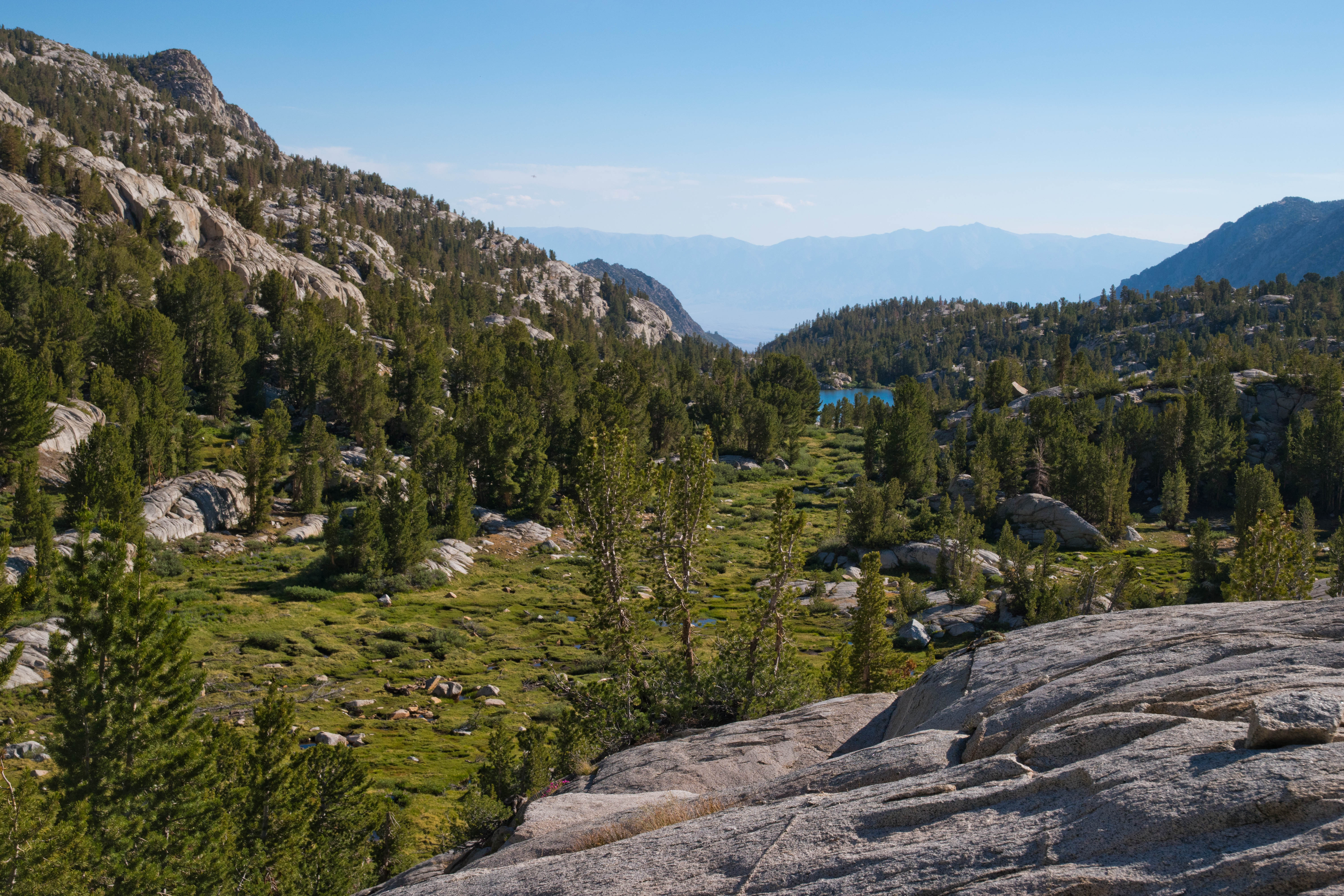
The trail arrived at a junction at 5.3 miles, with the main trail heading towards Midnight Lake while the left fork led towards Hungry Packer Lake. I took the left fork, which dipped down and crossed two wildflower-lined streams in quick succession. The trail undulated up and down until reaching a view over Topsy Turvy Lake at 5.6 miles. Here, the trail turned to the right (south) and began its final ascent into the valley containing Sailor Lake, Hungry Packer Lake, and Moonlight Falls.
 |
| Topsy Turvy Lake |
After a long 5.8 miles of hiking from the trailhead, the trail broke out of the trees and into the glorious alpine basin at the foot of Mount Powell and Picture Peak. The trail alternated between crossing granite benches and pristine alpine meadows here- the stretches of trail across meadow were incredibly striking and an exemplar of High Sierra scenery.
 |
| Meadows below Mount Powell near Sailor Lake |
At 6 miles into the hike, I came to the junction with the trail to Moonlight Lake. Hungry Packer and Sailor Lakes were down the right fork, while Moonlight Lake and Moonlight Falls were off to the left fork. While I had no intention of hiking to Moonlight Lake, I was able to see Moonlight Falls on the other side of the valley from the trail junction and made a spur of the moment decision to add a brief side trip to the falls. The falls were actually slightly off of the Moonlight Lake Trail and required some cross-country travel to reach; I followed the Moonlight Lake Trail about fifty meters, crossing Middle Fork Bishop Creek, and then struck out across the open granite, making a beeline for the falls. I had to cross another creek and bushwhacked through a slightly marshy area but I soon found myself at the base of Moonlight Falls. The falls is a fairly minor drop down a granite ledge, but it makes for an extremely picturesque scene when paired with the granite spires of Picture Peak and Mount Haeckel rising behind it.
 |
| Moonlight Falls and Picture Peak |
I found out later that I was only about a hundred meters away from Moonlight Lake as the crow flies from that viewpoint at the base of Moonlight Falls; however, as I was tight on time during my hike, I returned to the Hungry Packer Lake Trail and continued on the final stretch of this hike. The scenery here was absolutely marvelous and reached a climax when I arrived at the small but indescribably beautiful Sailor Lake at 6.2 miles from the trailhead. This lake was an alpine wonderland out of my most vivid High Sierra dreams: Picture Peak, Mount Haeckel, and Mount Powell all rose above its placid waters, with snow adorning the granite pinnacles and walls of those great surrounding peaks. Middle Fork Bishop Creek burbled happily as it tumbled down a meadow-lined path through the granite boulders, cascading in its final drop into Sailor Lake. The lake was alpine perfection: none of my words can approach doing it justice.
 |
| Sailor Lake |
Marmots darted around the meadows, pausing their naps and lunches to whistle to each other as they reacted to my presence.
 |
| Marmot in the meadows near Sailor Lake |
When I reached the far end of Sailor Lake, the trail began following Middle Fork Bishop Creek uphill through its meadow-lined path. Picture Peak rose directly behind the stream, creating a scene of extraordinary beauty. I was spellbound, my jaw agape at the High Sierra magic that was unfolding.
 |
| Cascading Middle Fork Bishop Creek above Sailor Lake |
Picture Peak's sharp pinnacle grew larger and larger as I hiked the final uphill. At just under 6.5 miles, I arrived at a narrow pond that formed the outlet to Hungry Packer Lake. Here, the trail crossed the lake and I followed the path another fifty meters until it petered out in a meadow just short of the lakeshore of Hungry Packer Lake. Crossing that meadow, I reached the hike's final destination. Hungry Packer Lake's waters were a beautiful blue, forming a stark contrast with the whites and grays that dominated the color of the imposing granite wall across the lake. Picture Peak's massive cliffs rose directly from the lake and the high spire of Mount Haeckel was visible behind Picture Peak. It was an arresting scene and a satisfying final reward to top off the bonanza of spectacular scenery in the hike's final mile.
 |
| Picture Peak and Mount Haeckel rise above Hungry Packer Lake |
It is unwise to make a general online recommendation for other people to embark on a rocky, steep, and long day hike with a chance for altitude sickness. However, hikers who are fit enough should absolutely make their way up the Sabrina Basin for its scenic delights. The alpine scenery around Moonlight Falls, Sailor Lake, and Hungry Packer Lake is as fine as any that I've seen in the High Sierra.


Beautiful area. I just returned from the area (did hikes to Lamarck Lakes and Big Pine Lakes). You must have been there in a previous year - as this summer it's still pretty wet and snowy!
ReplyDeleteYes, I was there last summer! My posts are often offset from my actual hikes by up to a year. How were snow conditions up by Big Pine Lakes?
Delete