 |
| Freel Peak and Lake Tahoe from Eagle Rock |
Difficulty: Easy, although a tad of scrambling may be needed at the summit
Access: Paved road to trailhead, no fee required
Eagle Rock is a massive outcrop on the west shore of California’s Lake Tahoe that provides lovely views of the blue waters of North America’s largest alpine lake while requiring a short hike of less than a mile round trip from the trailhead on Highway 89. This is a short but popular hike and it’s easy to see why when you’re at the summit: the sweeping views of the lake had here typically requires far more effort to reach. The trail is managed by the California Tahoe Conversancy, a California state agency that operates a number of tracts for recreation and conversation around Lake Tahoe.
I hiked Eagle Rock with Anna and a few visiting friends over July 4 weekend. The trailhead is a short drive from the Tahoe City area on the lake's West Shore and is about a 40 minute drive from South Lake Tahoe. Coming from Tahoe City, we followed Highway 89 south for 4.5 miles from the junction with Highway 28 and then came to the trailhead on the right (west) side of the road. Driving in, we could see Eagle Rock towering above the highway right before we reached the trailhead parking area. I encourage you to approach from the north, as it's far easier to pull into the roadside parking when driving southbound on Highway 89. There's room for parking for about at least ten cars here; the parking area is often full on summer weekends, but as the trail is short, turnover is pretty fast. There's no bathroom at the trailhead.
Leaving from the trailhead, the trail began to head west up the forested southern slopes of Eagle Rock. The trail was generally well graded through its early stretches but ascended steadily and reached the spine of Eagle Rock at 0.2 miles, at which point it made a wide turn to the east and began heading east along the northern slopes of the rock up towards the summit. At 0.3 miles, the trail broke out of the forest and onto a massive outcrop; the trail became very rocky here, with a bit of minor scrambling almost necessary at times to reach the top of the eastern face of the outcrop. The volcanic rock atop Eagle Rock was substantially rougher and more jagged than the smooth granite that is generally found elsewhere around Tahoe. The true summit was slightly to the west of where the trail ended, although the best views of Lake Tahoe were atop the cliffs above the east face of the rock.
The primary views from atop the cliffs of Eagle Rock extended in all directions but west. Lake Tahoe's placid blue waters lay below us to the east, separated from the rock by Highway 89 and the west shore's orderly conifer forests. From left to right, we could see many of the major peaks around the lake: Mount Pluto; the vast sweep of the Carson Range on the other side of the lake, which included the high summit of Mount Rose, the steep escarpment of Herlan Peak, and the barren summits of Freel and Jobs Peak; and the closer summits of Rubicon and Phipps Peaks in the Sierra Nevada, which rose above nearby McKinney Bay.
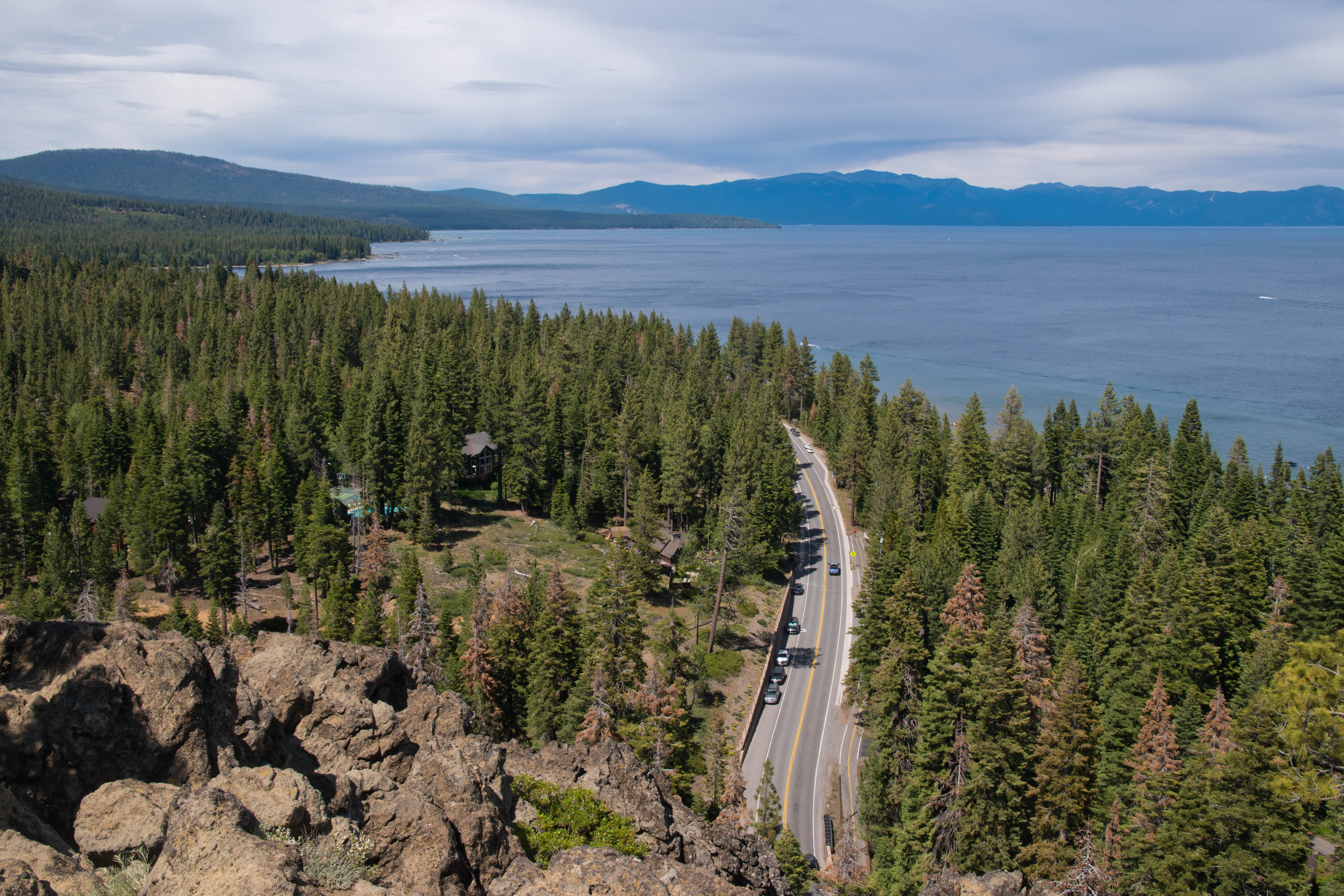 |
| Highway 89 passes below Eagle Rock |
 |
| Rubicon and Phipps Peaks rise above the blue waters of Tahoe |
 |
| Eagle Rock and Lake Tahoe |
Eagle Rock is a volcanic plug- it is the eroded remnants of a former volcanic vent. The outcrop is a testament to the importance of volcanic activity in the geologic history of the Lake Tahoe basin. In fact, the formation of the lake itself is due to volcanic activity: the formation of Mount Pluto, the rounded volcano on the northern end of the lake, around 2 million years ago, resulted in lava flows that dammed the outlet of the valley between the Sierra Nevada and the Carson Ranges, creating the alpine dream that we know today as Lake Tahoe.
After enjoying the summit scenery, we descended the way we came to end our short but very scenic outing. While this hike is not one of the highlights in the Tahoe area, it was an enjoyable leg stretcher and a worthwhile hour-long excursion for visitors with some extra time during a Tahoe trip.
No comments:
Post a Comment