Wednesday, April 29, 2020

Loowit Falls

Loowit Falls
9 miles round trip, 900 feet elevation gain
Difficulty: Easy-moderate
Access: Paved but crumbling road to trailhead, Northwest Forest Pass required

Loowit Falls plunges out of the unearthly crater of Mount St. Helens in a raw, unfinished world of crumbling rock, one of the most remarkable landscapes crafted by erosion following the volcano's cataclysmic 1980 eruption. This hike gets visitors as close to the off-limits crater of the volcano as possible short of summiting the volcano itself and provides an extraordinary look at both the extent of the volcano's devastation and the remarkable recovery that has occurred in the intervening four decades. Far from Seattle and Portland and a hefty drive from I-5, this hike sees a fraction of the visitors that pack the trails around other volcanoes in the Northwest.

I hiked Loowit Falls with a good friend visiting from San Francisco. From Seattle, we headed south past Puyallup, Eatonville, and Morton, following US 12 east from Morton to Randle and then taking the bumpy and pothole-filled Forest Service Road 25 south to Forest Service Road 99, which led towards the Windy Ridge area of Mount St. Helens National Volcanic Monument. NF-99 was an unpleasant drive: at points, parts of the downhill side of the road had slumped, creating somewhat dangerous driving conditions. We followed 99 to its end at the Windy Ridge parking area.

From the trailhead, we followed the gated road (Truman Trail, No. 207) south towards the mountain. The old road- built to access the plains at the base of Mount St. Helens shortly after the 1980 eruption and still used today by researchers- hugged the east side of the ridge. The devastated slopes, having recovered minimally, were populated only with bushes and wildflowers, meaning that the trail had open views of the surrounding valleys and peaks. Mount Adams was semi-visible to the east, floating in and out of the clouds as we hiked. We passed a small structure by the side of the road that turned out to be an earthquake monitoring station, part of a larger USGS system for monitoring seismic and volcanic activity at Mount St. Helens.

At about a mile, the road rounded a corner and Mount St. Helens came back into view. From this perspective, Dog's Head, the northeast corner of the crater rim, appeared particularly prominent and much of the rest of the crater was hidden behind the closer features of the mountain.

Mount St. Helens


We also had views out into the forested ridges of the South Cascades that filled the space between Mount Adams and Mount St. Helens. Notably, the degree of devastation experienced by any given area during the 1980 eruption could be determined by the degree to which that area had been revegetated.

Truman Trail View
Wildflowers have taken full advantage of the lack of foliage near Mount St. Helens: early each summer, the Devastated Area puts on one of the most spectacular flower shows in the state. We were lucky to catch numerous paintbrush blooming amidst fields of yellow and purple wildflowers on the otherwise barren slopes during our visit.

Wildflowers
After the road cut across to the west side of the ridge, it descended down to the ashy plains created from the massive landslide at the start of Mount St. Helens' eruption in 1980. The once conical summit of St. Helens crumbled and slid down the north side of the volcano as the volcano erupted, resulting in the largest recorded landslide in history that filled in the valley of the Nork Fork Toutle River. The road ended here; two trails left from the parking lot. The Truman Trail headed in the direction of Spirit Lake, so instead we took the left fork for the Windy Trail.

The Windy Trail began heading across the volcanic moonscape. This was the heart of the most devastated landscape in the aftermath of St. Helens' eruption: the very soil beneath our feet had only been deposited in the eruption less than four decades before. After crossing a broad wash, the trail ascended onto a plateau and then wandered west across this surreal landscape for the next mile. But despite all the ravages of the volcano upon this landscape, life was renewing: in some areas, the ground was covered in sheets of paintbrush and lupine.

Wildflower bloom and Spirit Lake
Wildflower bloom
After a mile, the Windy Trail met up with the Loowit Trail, a 30-mile trail which circumnavigates Mount St. Helens. At the junction, we took the right fork to head in the counterclockwise direction around the volcano. We were so close to the mountain now that Dog's Head, the northeast end of the crater rim, towered to the south and we could no longer make out the shape of the full crater rim.

The trail continued climbing in and out of shallow stream valleys as it traversed the northern base of Mount St. Helens; we rockhopped over multiple stream crossings. One particular stream valley was discordantly lush, one of the few breaks of dense vegetation in this otherwise harsh and sparse landscape. Here, a stream cascaded among blooming bunches of monkeyflower in a surreal oasis.

Monkeyflower blooming by a stream
After exiting our verdant interlude, we continued across this Cascadian Mordor until we reached a junction with the spur to Loowit Falls. We took this left fork, leaving the Loowit Trail and heading uphill towards a deep ravine cut into the mountain's slopes. As we first spotted Loowit Falls plunging into its stark gorge, the plumes of dust, the harshly lit clouds, and the raw rocky cut of the crater rim rising above made for a menacing scene.

Approaching Loowit Falls
We arrived at the rim of the gorge after about a half mile of hiking from the Loowit Trail. Here, we had an awesome view of the waterfall's 200-foot plunge into a canyon cut into layers of landslide debris and ash. There was just one other group at the falls as we lunched to this awesome view.

Loowit Falls
The waterfall is fed by the Crater Glacier, a new glacier that has formed since 1980 in the St. Helen's caldera around its lava dome.

Looking out, there were excellent views down the slopes of the volcano to Spirit Lake and Mount Margaret and Coldwater Peak. The fill from the landslide had created desolate plains at the bottom of the North Fork Toutle River valley. By raising the level of the valley, the landslide raised the level of Spirit Lake and created Coldwater and Castle Lakes further downstream; this buried Spirit Lake's former outlet into the Toutle River. In the aftermath of the eruption, the surface level of Spirit Lake rose steadily and threatened to cause catastrophic flooding in the Toutle River Valley were it to top the debris flow and quickly erode into it. In response, the US Army Corps of Engineers dug a 1.6-mile drainage tunnel to provide an outlet for the lake by letting it drain into the Coldwater Creek. Approaching four decades, the tunnel is now in need for repairs for the safety of downstream communities.

Spirit Lake
From our vantage point, we were just high enough to gaze over Windy Ridge to the Goat Rocks. The high, snowcapped ridge of Old Snowy, Ives Peak, and Mount Gilbert Custis was visible.

Goat Rocks
After sufficiently absorbing this desolate scene, we retraced our steps and returned to Seattle for some deep dish at Windy City Pie.

If you wish to see Mt. St. Helens up close and personal without climbing it, this is your hike. Hikes across the Toutle at Harry's Ridge and Mount Margaret provide beautiful views of the crater but for close-up views of the volcano and the raw landscape it has crafted, you should hike to Loowit Falls.

Eagle Cap

Glacier Lake, Glacier Peak, and the heart of the Wallowas viewed from atop Eagle Cap
19 miles round trip, 4100 feet elevation gain
Difficulty: Moderate-strenuous; although grades are reasonable, it's a long hike
Access: Bumpy gravel road to trailhead, Northwest Forest Pass required

The Wallowas, an isolated mountain range in northeast Oregon, are deservedly nicknamed Oregon's Alps, featuring numerous alpine lakes set beneath the state's tallest non-volcanic peaks. Eagle Cap, although not the tallest peak in the range, sits at the heart of the Wallowas' Eagle Cap Wilderness, providing stunning views of the scenic and wild interior of these remote mountains. This hike ascends through forests and meadows on the East Fork Lostine River to reach Mirror Lake before embarking on a spectacular final ascent through the granite alpine to the glorious views atop Eagle Cap. This is a very long day hike, which many may choose to do as a backpack with an overnight (or longer) stop at Mirror Lake. The views and relative isolation of this area make this hike one of the highlights of the Pacific Northwest and a jewel in the crown of North American hiking.

I hiked Eagle Cap during a six-day long road trip from Seattle to Hells Canyon and the Wallowas. I came in September, which was late enough in the season that all the snow from the previous winter had melted off the route but the first light snowfall of the coming winter had just dusted the mountains. August and September are likely the best times of year for this hike. The Wallowa Mountains are a long way from any city: Portland is 6 hours away and even Spokane and Boise are 4 hours driving from Joseph. Enterprise and Joseph are two small towns that are the primary populated areas near the range's more popular trailhead.

As the hike is quite long and September days in the Northwest don't have quite the same amount of daylight as midsummer days, I headed out early from Enterprise, starting my drive to the trailhead over an hour before sunrise. From Enterprise, I took Highway 82 west out of the town and followed it until I arrived at the small village of Lostine; when Highway 82 took a sharp turn to the right in the middle of town, I made a left turn at that point onto Lostine River Road, which led another 18 miles to Two Pan Trailhead, where the hike started. The first few miles of Lostine River Road were paved; after entering Forest Service land the road became gravel and the last stretch was quite narrow and bumpy. I parked at Two Pan Trailhead at the end of the road.

From the trailhead, I started out on the Lostine River Trail, which started in the forest with a gentle grade. The trail immediately entered Eagle Cap Wilderness, which encompasses much of the high country in the Wallowas and at over 360,000 acres is the largest wilderness area in Oregon. After a third of a mile, I came to a junction between trails that followed the East and West Forks of the Lostine River; I took the left fork here to follow the East Fork. From here, the trail began a steady climb through the forest, at times alongside the river and at times away from it, crossing the river at one point. A number of small, pretty waterfalls on the Lostine kept the ascent interesting.

Waterfall on the East Fork Lostine River
After about 2.5 miles and 1200 feet of uphill, the trail leveled out and the forest began to thin. After another 200 foot climb, the I entered a long, flat meadow valley and I caught my first glimpse of Eagle Cap rising far away at the head of the valley.

Eagle Cap rises above the meadows along the East Fork Lostine River
For the next nearly three miles, the hike was extremely pleasant. The grade was flat and rocky peaks rose from either side of the meadow; the sun was vaporizing morning dew and frost, creating sunlit swirls of mist rising from the grassy valley floor. The trail stuck to the west side of the valley meadows most of the time but provided frequent views of Eagle Cap.

Meadows in the valley of the East Fork Lostine
Approaching the head of the meadow, the trail crossed the East Fork Lostine on a falling apart log bridge. The East Fork Lostine Valley is remarkably flat and straight here: the terminus of the meadow valley is at a moraine that must at one point have formed from glaciers on Eagle Cap which today have left just remnant snowfields.

Eagle Cap and the East Fork Lostine
After crossing the East Fork Lostine, the trail cut through woods on the eastern side of the meadow and started to climb gently. About a half mile after the crossing, the trail began to ascend steadily again, switchbacking up the eastern side of the valley. Around 7 miles from the trailhead, the trees began to thin out and I entered an alpine landscape of granite and meadows.

Alpine terrain near Mirror Lake
Here, I arrived at a junction: the trail to the Lakes Basin broke off to the left, while the right fork led to Minam Lake and Eagle Cap. I took a quick detour on the trail to the left, which led to Mirror Lake in just a fifth of a mile. Mirror Lake is a shimmering gem at the base of Eagle Cap; I took a break by the lake before continuing the push to the summit. Mirror Lake is a more feasible day hike destination if you're not looking to cover 20 miles in a day, although Eagle Cap is a more impressive destination than the lake.

Mirror Lake and Eagle Cap
Mirror Lake
While this trail continues on to the rest of the Lakes Basin, I backtracked from the lakeside back to the junction with the trail to Eagle Cap and Minam Lake. This time, I took the other fork; almost immediately, I came to a second junction where the trail to Minam Lake led off to the right and the trail to Eagle Cap led to the left.

I took the left fork to head towards Eagle Cap. The trail crossed a wide, flat meadow with peeks of Mirror Lake in the distance and crossed a stream feeding into Mirror Lake. To the north, there were nice views of the meadows and mountains of the East Fork Lostine valley.

Mirror Lake in the distance
East Fork Lostine valley
The trail then embarked on a short climb along a tumbling stream, which brought me to the meadow-covered slopes just above Upper Lake. I took another short detour on a social trail down to Upper Lake to enjoy the tranquil lakeside scenery.

Upper Lake
The trail switchbacked as it ascended a rocky hill rising above Upper Lake; the views improved continuously as I got progressively higher up.

Upper Lake
The grade leveled out and straightened out as the slope of the hill became gentler, and the route ahead became more clear as views of Eagle Cap returned. The mountain was now quite close: up ahead, I could see the trail aiming for the northwest ridge of the mountain. The remnant snowfields on the north face of the mountain were now clearly visible. There is (was?) a single named glacier in the Wallowas, the Benson Glacier, but it's not clear for which body of ice that name was initially intended; some maps mark it as being on the north face of Eagle Cap, while other maps indicate that it is the body of ice on Glacier Peak to the south. While the north face of Eagle Cap was at one point glaciated, the snowfields there are stagnant and are certainly no longer glaciers.

Approaching Eagle Cap
The views to the back also improved during the climb: most notably, the magnificent west face and white limestone cap of Matterhorn rose above the Hurricane Creek valley, while Moccasin Lake came into view. Although Matterhorn is the second tallest peak in the Wallowas- Sacajawea Peak just to the north along the same ridge is 12 feet taller- along with Eagle Cap, it's one of the most remarkable looking peaks in the range.

Matterhorn and Moccasin Lake
A mile from Mirror Lake, I came to a junction: the trail over Horton Pass and down into the Eagle Creek valley broke off to the right. I took the left fork, which kept put me on the summit trail to Eagle Cap. The trail switchbacked up rocky talus slopes to gain the northwest ridge of Eagle Cap. Upon reaching the ridge, huge views opened to the southwest.

Wallowas
The trail stayed on the southwest side of the ridge and was quite narrow in places as it cut across the steep slopes of the ridge. At the far end of a bump on the ridge, I came to a saddle: from here, the ridge led directly up Eagle Cap. From the saddle, there were remarkable views down to the craggy landscape of rock and snow below on the north face of Eagle Cap as well as of Matterhorn and the East Fork Lostine valley in the distance. The massif of Eagle Cap rose straight ahead.

Eagle Cap Summit
From the saddle, the trail began its final ascent, climbing the last 600 feet through broad switchbacks on the the peak's western slopes. As I climbed higher, the viewshed expanded and soon I could see out of the Wallowas to the Elkhorn Mountains and Baker Valley.

Hidden Lake peeping out, Baker Valley in the distance
When the trail finally leveled out, I found myself at the 9572-foot summit of Eagle Cap. Due to my early start, I had the summit to myself for a while, allowing me to peacefully enjoy the majestic views of the surrounding Wallowas. And what views! I could of course see the many peaks and landforms that I spotted along the way up- Matterhorn, the East Fork Lostine Valley, Mirror Lake, Moccasin Lake, Hidden Lake cradled in a basin in the Eagle Creek Valley, and the Elkhorn Mountains. But the 360-degree view from the summit encompassed so much more: closer in, I saw the azul waters of Glacier Lake below. Glacier Peak, robed in snowfields, rose commandingly above the lake. This snowfield is the most likely candidate for the Benson Glacier- the snowfields on Glacier Peak are among the most extensive remaining ice features in the Wallowas and were confirmed to be live glaciers from observations in the early 20th century.

The impressive limestone and shale wall of Cusick Mountain, Sentinel Peak, Pete's Point, and Aneroid Mountain rose beyond Glacier Lake, forming a formidable divide from the Imnaha watershed and Hells Canyon. Although Hells Canyon was blocked from view, the Seven Devils were visible behind Sentinel Peak. Other peaks of the Idaho Rockies lined the horizon.

Glacier Lake
Mirror and Moccasin Lakes, Matterhorn
To the east, I spotted Blue Lake filling a cozy alpine cirque. China Cap Butte and the buttes of the basaltic Wallowas rising above the Minam River were visible beyond that and even further back I could see the hazy plateau of the Blue Mountains.

View towards the basaltic western Wallowas
I stayed at the summit for a whole hour- eventually, more hikers started coming up, mainly backpackers who were camping in the Lakes Basin. On my way down, I stopped at the first switchback to enjoy the views to the south of Glacier Peak, Red Mountain, and the Eagle Creek valley.

Glacier Peak and Benson Glacier remnants, Eagle Creek Valley
This is an extraordinarily beautiful hike; I highly recommend both the the hike itself and the Wallowas themselves to hikers who haven't glanced at this corner of the Northwest before.

Friday, April 24, 2020

Palouse Falls

Palouse Falls
1.5 miles round trip, 250 feet elevation gain
Difficulty: Easy-moderate; the path requires some very steep descents, shoes with good traction recommended.
Access: Good gravel road to trailhead, Washington State Discover Pass required

At Palouse Falls, the Palouse River takes a dramatic plunge into a canyon carved into the multi-layered Columbia River Basalts in the desert landscape of Eastern Washington. This is one of Washington State's most extraordinary waterfalls- in fact, it's the state waterfall- and it's a lovely spot to visit if you're in Eastern Washington. The falls are far from Seattle but are a must for anyone exploring the desertscape of the state's eastern half. No hiking is necessary to see the falls themselves but a short hike provides access to the river just upstream of the falls.

I visited the falls on Memorial Day weekend with two friends on a road trip out to Spokane. From Seattle, we took I-90 east to Vantage and exited onto Washington Highway 26 east immediately after crossing the Columbia River. We followed Highway 26 east past Royal City and Othello to Washtucna, where we turned right onto Highway 261 heading south. At the junction between 261 and 260, we made a left turn to stay on 261, which we followed through winding hills until reaching the turnoff for Palouse Falls State Park on the left. We then followed a gravel road for the remaining distance down to the trailhead at the end of the road, though heavy Memorial Day traffic meant we spent nearly a half hour just to get into the park and find parking.

The falls are directly next to the trailhead; if you're interested just in seeing the falls, it's not necessary to actually do any hiking.

Palouse Falls
Fences line the side of the canyon; don't venture onto any of the paths below the canyon rim here as the terrain here is steep and treacherous.

Palouse Falls would not exist without a confluence of factors that makes Eastern Washington's landscape a geological oddity. The columnar basalt of the cliffs forming the walls of the canyon are a result of the massive volcanic eruptions around 15 million years ago that released floods of mafic lava which covered the Columbia River Basin; during cooling, the basalt fractured into vertical polygonal arrays. The columnar nature of the rock makes the walls of the canyon particularly steep; the many layers of the walls represent the many flood basalt eruptions that occurred around that time. The tendency of the basalt to shed vertical columnar chunks during erosion makes possible a waterfall rather than a more gentle descent for the Palouse River. During the ice ages of the past hundred thousand years or so, heavy glaciation in the Rockies formed ice dams that created massive lakes on what is now the Clark Fork River. Glacial Lake Missoula and other Ice Age era lakes were released in phenomenal floods when the ice dams failed and floodwaters swept and scoured the Columbia River Basin, carving out the Channeled Scablands. One of the greatest of these erosive events was at Dry Falls on the Grand Coulee, where at the height of the floods the flow volume might have been as much as ten times as the flow of all rivers on earth combined, dwarfing contemporary falls like Niagara or Iguazu. The floods and those great falls are gone; Palouse Falls provides a glimpse of how a fraction of those ancient falls might have looked.

From the parking lot, we started our hike here by following the broad, paved path leading into the prairie towards the upstream direction. After a brief walk of about a hundred yards, we came to an unmarked but obvious junction where a wide trail led to the right; we followed this trail, which led to the rim of the canyon and followed it until coming to a point of land on the canyon rim high above the falls. This vantage point offered one of the best views of the canyon of the Palouse River cutting through the flood basalts.

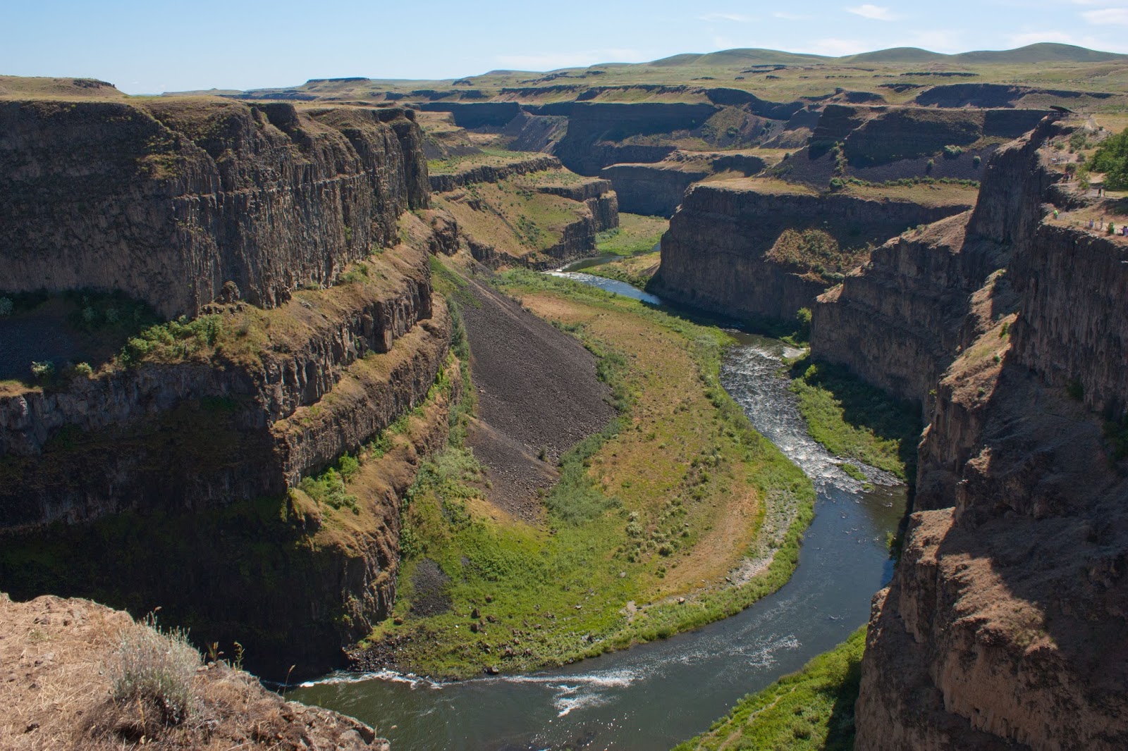
Palouse River canyon
From the point, we then followed the trail along the other rim back towards the main paved trail, with views into a narrow canyon just upstream of the falls. Following this trail about a quarter of a mile, we met back up with the initial paved trail at a wide gravel turnabout next to both the canyon rim and some railroad tracks. Looking down, we could see the Palouse River dropping down a few small cascades at the bottom of the steep-walled canyon. From here, a gravel path descended down part of the canyon wall to meet the railroad tracks at the top of a huge talus slope; we then followed the railroad tracks about fifty meters to reach a rocky path that descended through the talus slope to reach the bottom of the canyon.

Palouse River canyon
Once at the base of the canyon, we followed the clear path to reach a set of cascades on the Palouse River where it turned into a narrower stretch above the main falls. The basalt canyon walls towered impressively above.

Small falls upstream of Palouse Falls
This is a good spot to turn around, for a hike of about a mile round trip. Those who wish can continue on to reach the lip of the falls. We followed a social path to the right from the cascades, hiking in the downstream direction as we followed the river into an especially narrow part of the canyon. The trail narrowed as well, hugging the vertical walls.

Palouse River cuts through a canyon upstream of Palouse Falls
At the end of the trail, we emerged to a spectacular sight: a row of free-standing basalt columns known as the Feathers towered over the lip of Palouse Falls, which dropped off into the depths of the Palouse River canyon down below.

The Fingers
View down the canyon from the top of the falls
As there are no fences or railings for safety, it's important to exercise caution here: falls are fatal. We enjoyed the views and then retraced our steps, shortening the hike back by returning along the paved trail on the last leg.

After leaving the park, we drove further east on Washington Highway 26 to Colfax, deep within the rolling hills of wheat that define the Palouse. From Colfax, we headed just north to Steptoe Butte State Park and drove the winding road up to the top of the butte, where there was a sweeping, 360-degree view of the surrounding country.

Palouse wheatfields from Steptoe Butte

Palouse landscape from Steptoe Butte

Kamiak Butte

Palouse Hills from Kamiak Butte
2.5 miles loop, 700 feet elevation gain
Difficulty: Easy
Access: Paved road to trailhead, no entrance fee, open 7 AM to dusk

Kamiak Butte provides a stunning bird's-eye view of the gently rolling hills of wheat in the Palouse region of southeastern Washington. During springtime, the wave-like landscape of wheat is a verdant green while in fall, the wheat turns golden for harvest season. This easy hike in a county park in the heart of Palouse, just a short drive from the campus of Washington State University, is one of the best ways to see this pastoral landscape in the Northwest's most important wheat-growing region. If you happen to be in the area, Kamiak Butte is one of two spots (along with nearby Steptoe Butte) that provide these unique views of the wheat hills from above and is very worth visiting.

Kamiak Butte is at least a five and a half hour drive from Seattle; the closest city is Spokane and it is just outside the college town of Pullman. I hiked Kamiak Butte during mid-September while on the way to a trip to Hells Canyon and the Wallowas. From Pullman, I took Highway 27 north from the downtown about 10 miles. The highway skirted the eastern end of Kamiak Butte; I turned left at Clear Creek Road, following the sign for Kamiak Butte County Park. I followed Fugate Road when it broke off to the left from Clear Creek Road and then turned left at the sign for Kamiak Butte County Park. The park opens at 7 AM; I initially made the mistake of arriving before opening in hopes of seeing the sunrise. Having arrived too early, I returned to Pullman and did a brief walking tour through the Washington State University campus before returning to the butte to hike. The park road climbs up the lower slopes of the butte, with good views of wheat fields even before reaching the trailhead. The road dead ends at a campground but I parked a little earlier on at the day use parking area to start the hike.

Palouse wheat fields near Kamiak Butte
The trail started from the far end of the parking lot and headed uphill into the forest. Almost immediately, I came to a junction with the more direct trail to the ridge on the left and the more gradual trail to the summit on the right. I took the left fork for the more direct climb. The wide trail switchbacked through the forest for a half mile to gain the top of Pine Ridge, the primary ridge of Kamiak Butte. None of this hike is particularly strenuous but this is more or less the most physically strenuous bit of the trail. As the trail reached the top of the ridge, I arrived at a clearing with views to the south over the Palouse Hills. The town of Pullman was in the distance, an oasis of green trees and stately buildings nestled amongst the golden hills, and the forested mountains of the Palouse Range rose to the southeast near Moscow, Idaho, signaling the start of the Rocky Mountains.

Palouse
Palouse Range from Kamiak Butte
The Palouse Hills are made of windblown loess, a result of Eastern Washington's dramatic and contorted geological history. During previous ice ages, advancing glaciers turned into ice dams on the Clark Fork River in Idaho, creating Glacial Lake Missoula and other ice age great lakes that stretched into Montana. Massive floods swept Eastern Washington when the ice dams failed, sculpting the Channeled Scablands and depositing fine silt across the region. Winds carried this silt and deposited it to the southwest at the foot of the Blue Mountains, forming the gentle and fertile loess hills that we see today.

The loess deposited in these hills has made the Palouse one of the most fertile agricultural regions in the country. These hills grow lentils, barley, and chickpeas, but the predominate crop is wheat. While the Midwest and the Great Plains are usually thought of as the nation's breadbasket, the Palouse makes Washington State the US's fourth largest producer of wheat. Much of the Palouse crop is exported, taking advantage of barge shipping along the Snake and Columbia Rivers through the locks that accompany the eight dams between Lewiston's slackwater and Portland's tidewater. In the spring, the young wheat is green, making the hills here unbelievably verdant; by summer, the green matures to a rich gold, which is the primary color of the Palouse until the harvest ends in the fall.

Those looking for an even shorter hike can turn around here after enjoying the views and return via the switchbacks to the trailhead; however, if you have time, I recommend completing the loop by following the Pine Ridge Trail west to the summit of Kamiak Butte.

Over the course of the mile from the first viewpoint to the junction for Kamiak Butte's summit, the trail climbed about 400 feet in a reasonably gentle grade along Pine Ridge. The trail along the ridge had constant views to the south; the dichotomy between the open, grassy south slopes and the heavily forested north slope illustrated the effects of sunlight on moisture and forest growth in this landscape. The ever higher angle for outward views increasingly brought out the features of the town of Pullman.

Pullman and WSU from Kamiak Butte
Pullman is home to Washington State University, one pole of Washington State's principal college rivalry. Although I did my graduate education at the University of Washington, WSU was a school that had some meaning to me: my uncle had worked here as an agricultural researcher at one point, telling me stories about how he used to have to trek to Moscow, Idaho to get McDonalds. UVa's celebrated men's basketball coach, Tony Bennett, once coached here and led a WSU team with Klay Thompson on the roster back to PAC12 relevance before leaving for Virginia with Chelan native Joe Harris for a decade of rebuilding by alma mater's team into national championship material.

Although views were primarily to the south, at one point I found a small clearing that provided a view to the north and northwest instead. From here, I could spot Steptoe Butte, a pyramidal peak rising from the wheatfields. Steptoe Butte- the sister to Kamiak Butte- is one of the few geographical features to rise above the loess hills to provide a bird's eye view, and is a lovely spot where one can drive to the summit for an overview of the surrounding countryside.

Steptoe Butte from Kamiak Butte
At 1.5 miles into the hike, I arrived at a junction: the principal trail turned right here to head downhill and back to the parking lot, but a spur trail led to Kamiak Butte's summit, which is on private land. I took the spur, which climbed quickly to the butte's summit, where there were limited views. I backtracked to the junction and continued around the loop, returning towards the trailhead on the north side of the butte.

While the south side of the ridge was dry and sunny, the north side was a more familiar scene for the Pacific Northwest: a dense, green forest of firs, pines, and larches with copious undergrowth. The well-built trail descended on a dirt tread through the forest at a gentle incline.

Forested trail on Kamiak Butte
Although this stretch of trail was much more forested, at one point a view opened up to the northeast, where in the distance I could see the forested westernmost ranges of the Rockies rising from the Palouse.

Palouse wheat fields and the start of the Rockies in Idaho
After most of a mile of downhill hiking from the summit, a side trail led to the campground; I stayed to the right to continue back towards the day use parking area. Very shortly afterwards, I arrived back at the first junction; turning left, I was back at the trailhead.

If you enjoyed the scenery from Kamiak Butte, or if you want to see the rolling wheat hills from above without any hiking, nearby Steptoe Butte, just north of Colfax, is a highly recommended vantage point for gazing out over the Palouse. A potholed road leads to its summit, from which one can gaze out over Eastern Washington's pastoral hills.

Palouse Hills in spring from Steptoe Butte