 |
| Mount Eisen and Sawtooth Peak from Little Baldy |
3.5 miles round trip, 800 feet elevation gain
Difficulty: Easy-moderate
Access: Paved road to trailhead, Sequoia National Park entrance fee required
While overcrowded Moro Rock gets the most love of the granite domes of California’s Sequoia National Park, the much higher granite dome of Little Baldy provides nearly equal views of the snowy Sierra Nevada with just a fraction of the tourist hordes that crowd Moro Rock and nearby Giant Forest. Seeing the majestic granite wall of the Great Western Divide is a key visitor experience at Sequoia National Park and almost all visitors get their fix on the narrow rock staircase of Moro Rock. Little Baldy offers a comparable view on a slightly longer but eminently enjoyable hike- it’s a worthy and recommendable hike for casual visitors who want to experience the park’s alpine beauty with a bit more peace and quiet.
We hiked Little Baldy on the last day of a Memorial Day weekend trip to Sequoia National Park. The trail is most easily accessed from Highway 180 and the Grant Grove entrance to Sequoia-Kings Canyon National Park. From Fresno, follow Highway 180 east to the Grant Grove entrance and then follow Generals Highway south for 18 miles to reach the trailhead at Little Baldy Saddle. From the Giant Forest Museum, it is a straightforward eleven-mile drive north along Generals Highway to reach Little Baldy Saddle. There are wide shoulder pulloffs on both sides of the road at Little Baldy Saddle for parking, but no toilet; the limited parking, which can accommodate about 10-12 cars, reflects the fact that this hike is far quieter than Giant Forest.
The Little Baldy Trail started on the east side of Generals Highway, immediately embarking on an uphill climb through a pine forest through a short series of switchbacks. The trail had a comfortable dirt tread but ascended at a steady, moderate grade. While the forest near the trailhead was initially fairly intact, we soon began entering burn zones with varying degrees of damage done by the 2021 KNP Complex Fire. In some areas, the fire had been quite severe, blackening the ground and killing the pines entirely; in other areas, bushes, flowers, and other underbrush remained virtually untouched.
 |
Burnt forest
|
As the trail passed through some longer switchbacks, partial views to the northwest began opening up. The most notable element of this view was the larger, rounded granite dome of nearby Big Baldy, but this also provided a spot for me to assess some of the damage from the KNP Complex Fire. Thankfully, I was able to confirm from these views that Muir Grove, a particularly majestic grove of Giant Sequoias across a small drainage, was largely intact, with most of the broccoli tops of its mature giant sequoias still fully green. However, it was clear that the fire had badly scorched the slopes of Big Baldy a little farther away; later that day, I would discover unspeakably tragic destruction that the fire wrought in Redwood Mountain Grove.
 |
Big Baldy and Muir Grove
|
We saw no fewer than seven marmots over the course of the hike: these furry rodents were happily nibbling away at trailside plants until they noticed our approach and scurried into their underground homes.
 |
Marmot
|
After 1.1 miles of continuous ascent and about 600 feet of elevation gain, we arrived along the ridgeline of Little Baldy. The trail finally flattened out from the extended (though moderate) ascent. Here, I encountered some severe fire damage as I followed the undulating and wide ridgeline: quite a few trees of this ridgetop forest had been consumed in conflagrations. Much of the soil here had been turned over, evidence of an intense and ultimately unsuccessful effort by firefighters to stop the fire here and prevent its northward spread towards Redwood Mountain Grove.
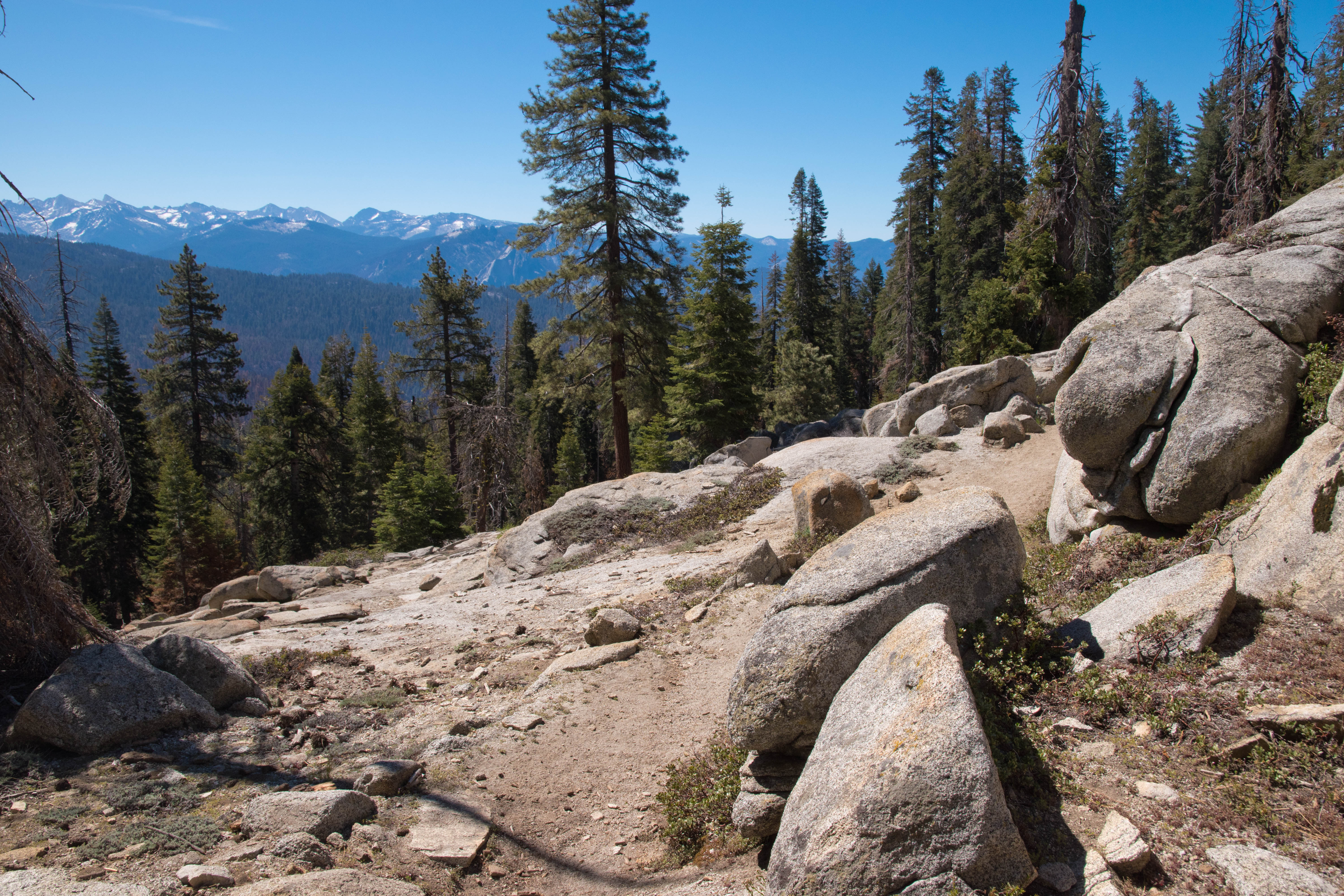
After a flat stretch, the trail began another brief gentle ascent that peaked at an open granite outcrop that provided our first views to the east, at 1.4 miles from the trailhead. And what views! The nearby summits of Mount Silliman and Alta Peak dominated the view, still capped in early season snow. Farther away, we could see many peaks of the Great Western Divide.
 |
Great Western Divide views along the ridge
|
Leaving this granite outcrop, the trail dropped briefly to a forested saddle and then began a longer final climb to the summit of Little Baldy. The trail wrapped climbed steadily through the forest and wrapped around to the east side of the ridge before popping out onto the open granite just about fifty meters short of the summit. Here, the marked trail ended; a final short ascent up the granite dome brought us to the summit of Little Baldy at 8044 feet above sea level.
 |
Final approach to Little Baldy's summit
|
We were treated to a sweeping, 360-degree panorama at the summit, with the Great Western Divide to the east, Giant Forest and the foothills to the south, and the Central Valley to the west. Mount Silliman and Alta Peak were the closest mountains to the east, with the snowy granite Tableland of the Kings-Kaweah Divide visible between those two prominent peaks. Even from this distance, we could see the silver thread of Tokopah Falls cascading down the granite slopes in the deep valley between Silliman and Alta. South of Alta Peak rose the mighty wall of the Great Western Divide: Mount Kaweah, Mount Eisen, Sawtooth Peak, and Vandever Mountain were among the prominent and snowy summits visible from Little Baldy. While we could not really see much of the Middle Fork Kaweah Canyon itself, we could see Paradise Peak and Castle Rocks on the south side of the canyon and we could even see the small rocky fin of Moro Rock rising out of Giant Forest’s expanse of green broccoli-top sequoias. Past Castle Rocks, the Sierra Nevada dropped off precipitously to the foothills and then to the flat agricultural fields of the Central Valley. The Caliente and Temblor Ranges were visible west across the Central Valley, while the high peak of distant Mount Pinos in the Transverse Ranges was visible at the southern end of the valley on this clear day.
 |
Great Western Divide
|
 |
Mount Silliman, Alta Peak, and Tokopah Falls
|
 |
Foothills and Central Valley from Little Baldy
|
Large swaths of devastated forest incinerated by the 2021 KNP Complex Fire were visible. On the ridge running south from Little Baldy, I spotted the badly burned Suwanee Grove, where only a handful of green mature sequoia tops were mingled with a graveyard of pine and sequoia corpses. The forests on the slopes west of Giant Forest were also severely burned; Little Baldy provided an excellent vantage point of how close Giant Forest was to reaching its demise last year. While giant sequoias generally benefited from past wildfires, a drier and hotter climate in the Sierra Nevada has led to multiple deadly conflagrations since 2015 that have wiped out at least a fifth of the population of mature sequoias in just a few short years. It’s a sobering reminder of the consequences of human-driven climate change and a call to action for us to demand policies that can have real effects to mitigate the damage.
 |
Giant Forest, KNP Complex burn scars, Moro Rock, and Castle Rocks
|
 |
Suwanee Grove fire damage
|
We saw about ten other hiking groups on this trail on a nice Memorial Day morning in about two and a half hours of hiking; while at the summit, we had the views entirely to ourselves for about 15 minutes.
Little Baldy is a lovely and quieter Sequoia National Park hike with fabulous views of the Great Western Divide. While more rugged hikers may be better off spending their time exploring the High Sierra trails of Mineral King or hiking Alta Peak, most casual hikers will find this hike to be in their sweet spot. This is a recommended trail for those visitors who want to enjoy mountain views without too much distance and elevation gain or too many crowds.


No comments:
Post a Comment