Friday, October 5, 2018

Skyscraper Mountain

Mount Rainier from Skyscraper Mountain
8.5 miles round trip, 1500 feet elevation gain
Difficulty: Moderate, some minor scrambling necessary to reach summit
Access: Paved road to trailhead, Mount Rainier National Park entrance fee required

Skyscraper Mountain is one of the many day-hike destinations in the Sunrise area of Mount Rainier National Park; as it sees far fewer visits than more popular Summerland, Mount Fremont, and Burroughs Mountain, it is also one of my favorite hikes in the area. As one would expect of a peak named Skyscraper, the summit offers sweeping views of Mount Rainier and its environs, including peeks at both the largest (Emmons) and lowest elevation (Carbon) glaciers in the contiguous United States. The hike is entirely in the alpine, with constant views from the trailhead to the summit. Although this trail is less popular than its nearby peer destinations, it's still a good idea to visit Sunrise on a weekday or arriving very early on weekends, as entrance into this portion of the park may be restricted on busy summer weekends.

I hiked Skyscraper Mountain on a beautifully clear July day with a friend visiting from Virginia. We left Seattle early to avoid weekday traffic, taking I-5 south, then Highway 18 east to Auburn, then Route 164 south to Enumclaw and Highway 410 east through Greenwater to the entrance of Mount Rainier National Park. Once in the park, we continued on Route 410 until reaching the turnoff for Sunrise; here, we turned right, passing the entrance gate and the White River Campground before following the road up the winding switchbacks to the Sunrise Visitor Center, where we parked to start our hike.

From the day lodge at Sunrise, we followed the road towards the picnic area and then hopped onto the trail towards Sourdough Ridge. At the junction between the connector trails leading east and west towards Sourdough Ridge, we took the west (left) fork, ascending through the meadows with amazing views of Mount Rainier, Little Tahoma, and the Cowlitz Chimneys. In a third of a mile, the trail met up with the Sourdough Ridge Trail atop the meadow-crowned ridgeline with a view directly down into Huckleberry Basin to the north and out to the far off peaks of the Central and North Cascades.

We would've stopped to enjoy the view, but we were quickly surrounded by a mob of flying, biting insects. To avoid being the main course of a mosquito buffet, we took the left fork on the Sourdough Ridge Trail and began following the trail west towards Frozen Lake and Burroughs Mountain. The views of the massive Emmons Glacier spilling down from Columbia Crest and the unsettling levelness of Burroughs Mountain made the progressions of ups and downs along the ridge easy to handle.

Rainier and Burroughs from the Sourdough Ridge Trail
We passed a junction with the trail to Huckleberry Creek and then continued along the Sourdough Ridge Trail. The trail crossed a scree slope where some amazing trailwork had been done: here, a wide corridor had been cut through the talus, with an impressive stacked stone wall defining the north side of the trail. Past the talus slope, the trail made a short climb to arrive at Frozen Lake. In early July, the lake lived up to its name: a snowfield remained on the northern and western shores of the lake and a number of small icebergs had been calved into the lake itself. Skyscraper Mountain, Mount Fremont, and Burroughs Mountain rose to the three sides around the lake. As the lake is the principal water supply for Sunrise, the lakeshore was blocked off from public access.

Frozen Lake with Skyscraper Mountain visible in the distance
At the far end of the lake, we came to the junction with the Wonderland Trail, the Burroughs Mountain Trail, and the Mount Fremont Trail. The Mount Fremont Trail led off to the right towards the lookout on Fremont; the Burroughs Mountain Trail led off to the left, heading straight up the steep sides of the mesa-like mountain. The Wonderland Trail headed to the east in one direction to return to Sunrise and west in the other direction towards Berkeley Park; we chose to head west, following the path that led straight through the junction.

Rainier rises above the Burroughs Mountain Trail
The Wonderland Trail passed through the alpine saddle between Burroughs Mountain and Mount Fremont before it began to descend into upper Berkeley Park in the basin north of Burroughs Mountain. The steep sides of Burroughs hid most of the bulk of Mount Rainier, leaving only the glacier-covered cap of Columbia Crest and the rockier Liberty Cap visible as we descended slightly into a valley. The trail to Berkeley Park broke off to the right; we stayed on the Wonderland Trail, heading west.

The Wonderland Trail
Although the peak wildflower bloom had yet to commence, upper Berkeley Park was already beginning to put on a flower show, with white heather blooming widely across its meadows and a good number of vividly colored magenta paintbrush.

Paintbrush and heather
As the trail circled around the cirque at the head of Berkeley Park, we had good views of both nearby Skyscraper Mountain and Mount Fremont and out the valley to Glacier Peak and the Central Cascades. Hiking well above the treeline, we had constant views of Rainier's attendant peaks.

Skyscraper Mountain
Mount Fremont
Rainier itself poked in and out of view, sometimes emerging from a saddle or dip in the ridge above to complement the green meadowed slopes of the trail.

Rainier
Wrapping around the back of the basin, the trail then began to traverse north along the western side of the valley towards Skyscraper Pass. We crossed a short section of snow to reach the pass on the ridgeline of Skyscraper Mountain. From the pass, Rainier was resplendent to the south: we had a clear view past Third Burroughs Mountain to the Emmons and Winthrop Glaciers, Liberty Cap, and Observation Rock.

Rainier from Skyscraper Pass
At the pass, an unmarked trail led to the right towards Skyscraper Mountain. We left the Wonderland Trail here, following this social path slightly down to a saddle before beginning a steady ascent through meadows towards the Skyscraper summit. This was the steepest portion of the hike, climbing 400 feet in a third of a mile to reach the 7077-foot summit. At points, the trail required what might qualify as minor scrambling as it followed the south ridge of the mountain towards the peak; there was a spot with some minor exposure just short of the summit. The climb was through completely open alpine slopes, allowing us to spot a group of mountain goats lounging about lower on the western slopes of the mountain.

Final ascent up Skyscraper Mountain
The rocky summit commanded a 360-degree view of Mount Rainier and the Cascades. The Fryingpan, Emmons, Inter, Winthrop, and Carbon Glaciers all made appearances on the great slopes of Rainier. Mount Fremont rose to the east above the meadow-filled valley of Berkeley Park, crowned with its oft-visited fire lookout on its north ridge. The sharp double spires of Sluiskin Mountain rose to the west. The remarkably flat, table-like Grand Park lay just to the north and beyond it rose the many peaks of the Central Cascades: Kaleetan, Chair, Glacier, Chikamin, Daniel, the Stuart Range. The relative lack of bugs at the summit made it a nice place for us to enjoy a long break before returning the way we came.

Skyscraper Mountain views
Mount Fremont and Berkeley Park
Glacier Peak and the Cascades rise over Grand Park

Saturday, September 8, 2018

Condor Gulch-High Peaks Loop

The High Peaks of Pinnacles National Park
6 miles loop, 1450 feet elevation gain
Difficulty: Moderate; rock scrambling in slightly exposed areas
Access: Paved road to trailhead, Pinnacles National Park entrance fee required

Pinnacles National Park preserves a collection of rock spires in California's Coast Ranges. The Condor Gulch-High Peaks Loop is perhaps the best known and most intimate way of experiencing these odd rocks, offering a scramble route through the heart of the formations. The hike delivers a variety of small delights: rock gargoyles, chaparral landscape, talus caves, and a lake. This is a good place to spot the rare California Condor.

Visitors should be prepared for rock scrambling and ascents and descents on narrow rock staircases with mild exposure. Hikers planning on visiting Bear Gulch Cave should be sure to bring a flashlight as well.

I've hiked the Condor Gulch-High Peaks Loop twice, both times while visiting a good friend who lives in the San Francisco Bay Area. While the first visit was a day trip, the second hike was a camping trip arranged after an aborted attempt to ascend the Four Mile Trail to Glacier Point in March due to snow. From San Jose, we followed US 101 south to Gilroy and then took Highway 25 east through Hollister and then south to the entrance of Pinnacles National Park. Following the Pinnacles Highway into the national park, we passed the visitor center and continued all the way to the large parking area at Bear Gulch. We parked at the Bear Gulch Day Use area. While the park seemed much quieter during my March 2014 trip, by March 2018 visitation to the park was apparently skyrocketing and a shuttle system had been implemented to ease congestion and parking problems at trailheads.

We started our hike by heading up the Condor Gulch Trail. The trail began an immediate ascent and the park's namesake pinnacles were soon visible above us. As the trail climbed through well-graded switchbacks, more and more rock spires entered our field of view. About a mile into the hike, an overlook to the left of the trail provided a view from atop a cliff over the rocky gulch.

Pinnacles from the Condor Gulch Trail
Past the overlook, the trail wrapped around the side of the mountain and then came out atop a ridge. From this ridge, there were beautiful and open views of the Pinnacles High Peaks and of the many ridges defining the California Coast Ranges.

Hiking high along the ridge above Condor Gulch, we spotted not one or two but three of the canyon's namesake animals. Three California Condors, the largest land birds on the continent, soared overhead. These vultures with 10-foot wingspans were hunted to extinction in the wild during the twentieth century, but are today making a comeback due to an extraordinary effort to save this critically endangered species. In 1987, the total population of California Condors numbered just 22, all in captivity, but through an ambitious conservation program, captive bred populations of condors were raised and then released back into the wild. Today there are around 300 wild California Condors; the three we saw at Pinnacles was fully one percent of the species' total wild population.

California Condor
The Condor Gulch Trail ended at a junction with the High Peaks Trail atop a lofty ridge. At this junction, we took the left fork to head west towards the High Peaks. Views now expanded to the north: the peculiar, almost grotesque shape of the Balconies rose to north. As we followed the ridge west, the density of pinnacles around the trail itself rose: soon we were surrounded by a menagerie of breccia gargoyles.

The Balconies
A half mile along the High Peaks Trail, we came to the junction with the Tunnel Trail, which headed downhill towards the trailheads on the western side of the park and provided a bypass for the trickier terrain of the High Peaks Trail. We stayed on the High Peaks Trail here, opting for the rock scramble/staircases through the most spectacular landforms of the park.

Park literature advises that the High Peaks Trail is steep and narrow; what this means is that the trail ascends and descends a number of high angle rock staircase and ladders and squeezes along rock ledges at spots. Mild rock scrambling is necessary at times and the trail may pose a problem for those with a fear of heights, but dangers are minimal for careful hikers as the National Park Service has installed metal railings along most exposed stretches of trail. While the total length of trail between the Tunnel Trail junction and the Juniper Canyon Trail junction is 0.7 miles, only a couple hundred meters of hiking during this stretch are actually more difficult.

Ladder portion of the High Peaks Trail
The rewards of hiking through this rougher terrain (if you are not someone who finds rock scrambles to be an inherently rewarding activity) are the close-up and dramatic views of the heart of the Pinnacles. These stone towers of andesite and breccia were formed by volcanic activity of Neenach Volcano some 23 million years ago. The volcano formed at the plate boundaries of the Pacific and North American plates; while the other remnants of Neenach Volcano are near Lancaster in Southern California, the Pinnacles have moved halfway up the state via strike-slip motion along the San Andreas Fault.
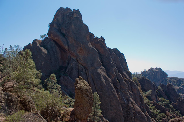
The High Peaks of Pinnacles
Part of the way through the High Peaks scramble, we met a few rangers who were using radio trackers to check in on the status of nearby condors.

At the end of the High Peaks scramble, the trail came to a junction with the Juniper Canyon Trail at a saddle. From here, a social path led uphill to a nearby rocky high point, which delivered one of the most impressive overviews of the Pinnacles.

View towards Chalone Peak
Leaving the saddle, we continued on the High Peaks Trail as we began to descend towards Bear Gulch. The trail switchbacked as it dropped quickly amongst the spires; at points, the landscape was so rocky and steep that the trail passed through short tunnels cut in the rock formations.

Rock tunnel in the descent from the High Peaks Trail
As the descent began leveling out, we came to the junction with the Rim Trail. Here, we took the right fork and followed the Rim Trail down towards Bear Gulch Reservoir. The trail cut across the chaparral slopes of a hill until coming to the rim of Bear Gulch. Here, Bear Gulch was very narrow- just meters wide between the sheer rock walls that bounded it on either side.

Bear Gulch
The Rim Trail ended at Bear Gulch Reservoir. Chalone Peak and a variety of rocky pillars rose above the small dam and lake, which seemed quite natural in the chaparral landscape. We chose to have lunch here, following the trail towards Chalone Peak along the lakeside away from the dam briefly to find a quiet spot to ourselves. As we were now quite close to the road again, the rocky outcrops along the lakeshore near the dam were busy with visitors.

Bear Gulch Reservoir
There are two routes back to the Bear Gulch Trailhead from the reservoir: the Moses Spring Trail stays above ground but is often the only option when the Bear Gulch Cave is closed. We decided to return through the Bear Gulch Cave, which is closed seasonally for the bats that inhabit it- check the status of the cave on the National Park Service website before you go. The cave is generally closed during the early summer (May-July) and may close at other times if the bats are not hibernating.

From the dam, a staircase leads down into Bear Gulch Cave. The cave is talus cave- very different in feel and in geological past from the more familiar and famous karst caves of Carlsbad Caverns or in the Shenandoah Valley. The cave is simply the bottom of the Bear Gulch- massive rocks have lodged into the narrow canyon walls over time, forming a roof over the canyon itself. A stream flows through the cave. At first, the trail passed by skylights created by gaps in the talus above, but it soon descended into nearly total darkness in the heart of the cave- bring a flashlight! The trail followed a metal grating walkway at points as it descended, passing small cave waterfalls and small pools in the darkness.

Bear Gulch Cave
Emerging from the other side of the cave, we walked out into the greenery lining the creek in Bear Gulch. We followed the trail gently downhill, joining the Moses Spring Trail and taking it back down to the road. A final stretch of trail parallel to the road brought us back to where we parked the car at Bear Gulch Day Use Area.

Friday, September 7, 2018

Church Mountain

View of the North Cascades from Church Mountain
8.5 miles round trip, 3700 feet elevation gain
Difficulty: Moderate-strenuous
Access: Bumpy gravel road with a creek crossing to the trailhead, Northwest Forest Pass required

Church Mountain rises steeply from Washington's North Fork Nooksack River Valley, jutting like a rocky steeple along a meadow-filled divide north of Mount Baker. The former fire lookout site at the lower summit offers views of Mount Baker, the North Cascades, and Canadian peaks while the mountain's green slopes are profuse with wildflowers in midsummer. This is a gorgeous destination accessible with a stretch of switchback work in the forest and is quieter than more popular nearby destinations like Skyline Divide, Heliotrope Ridge, or Yellow Aster Butte.

I hiked Church Mountain with two friends (sisters!) on a summer Saturday when overcast weather hung over the Puget Sound but the sun was shining in the mountains. From Seattle, we followed I-5 north to Burlington, then Highway 20 east to Sedro Wooley, Highway 9 north from Sedro Wooley to its junction with 542 (the Mount Baker Highway). I took the Mount Baker Highway east past the village of Glacier, crossing the Nooksack River before turning left onto the East Church Mountain Road. I followed the Church Mountain Road uphill four miles to the trailhead; this gravel road was generally in decent shape, although at one point I had to drive through a road washout at Fossil Creek. I handled this fine with a sedan, but a higher clearance vehicle may be better when the water level in the creek is higher earlier in the summer.

From the trailhead, we followed an old road trace gradually uphill for the first half mile of the hike. The trail left the road at the first switchback and began a steady uphill climb through an endless series of switchbacks. The trail generally maintained a nice dirt tread with switchbacks that weren't too steep, but the endless back-and-forth along the slopes of Church Mountain still got tiring, especially since a friend and I were carrying 30-pound packs to train for our upcoming climb of Mount Rainier. There were no open views early in the hike, though there were spots where we could peek through the foliage to see the ridge of Skyline Divide rising on the other side and some corners of Mount Baker just beyond.

The trail started opening up as we approached the 3-mile mark. Crossing two small clearings, we encountered blooming wildflowers- monkeyflower, lupine, aster, and paintbrush- as well as narrow views of the Twin Sisters in the distance. A little bit further forward, the trail entered a wide, open meadow in a bowl on the high slopes of Church Mountain. Plenty of wildflowers were blooming here, including valerian and tiger lilies. Wandering through the meadow, we caught our first clear views of Mount Baker, which was lucky as incoming clouds soon covered Mount Baker for the rest of the day.

Mount Baker from the Church Mountain Trail
The trail crossed a bubbling stream that was fed by pretty waterfalls on the higher slopes of the mountain. Wildflowers were profuse as were bugs; we kept moving to avoid being insect lunch.

Stream through the meadows on Church Mountain
The trail then began climbing out of the bowl, making some switchbacks as it climbed higher up in the meadows. Wildflowers were a constant companion, as were views of the high cliffs of Church Mountain above us.

Meadows of Church Mountain
At this point, Mount Shuksan emerged. Mount Baker is the tallest of the peaks in this area of the Cascades; Shuksan is the second-tallest. The summit pyramid of Shuksan rose regally from the peak's throne of glaciers.

Mount Shuksan
The meadows were lined with blooming heather and the bright green leaves of huckleberry bushes. While most July and August visitors would be able to best appreciate the flowers, late season visitors would likely have a berry feast here each fall.

Heather and huckleberries
The trail emerged into the upper portion of the meadow along the south ridge of the mountain. After climbing up onto the ridge, the trail made a sharp switchback and swung back to the east. The dirt path was often narrow and angled here as it made its way through grassy fields of valerian.

Church Mountain upper meadows
The trail made a final steep switchback at a subalpine meadow campsite and cut east across the slopes to reach the south ridge again, coming to a knob where the dirt trail ended at the base of a rocky block. Views were expansive here: we could look to the west and see directly down the slopes of Church Mountain to the Nooksack River and the Mount Baker Highway.

Trail through the meadows, Canadian and American Border Peaks and Mount Larrabee in the distance
Beyond the knob, the trail made a sharp switchback and began ascending the rocky summit block. A cable seemed to offer a handhold for ascending a steep, rocky route to the summit, but I found that it was easier to cut to the right and follow a less steep path that reached the summit with less exposure. The hike ended at a former fire lookout site, a false summit of Church Mountain: the true summit block was just west, a castle-like tower of stone. Snow patches still dotted the northern slopes of the mountain, feeding two small tarns in the bowl to the north of the summit. A third summit of Church Mountain lay just to the east, its meadow-crowned spire connecting to the verdant slopes of the Excelsior Divide. Only a few forested ridges to the north separated where we stood from the Canadian border; unfortunately, low clouds kept us from seeing across the Fraser River valley to the southern summits of the Pacific Range. On a clear day, it's likely that we could've seen past Abbottsford to Mount Robie Reid and Mount Judge Howay.

Church Mountain summit and lakes north of the ridge
Although Mount Baker had ducked into the clouds to the south, the panorama of North Cascades peaks to the east was on full display. Excelsior Peak and the green slopes of the High Divide led towards Mount Tomyhoi, Mount Larrabee, and American and Candian Border Peaks. Mount Shuksan towered over the Nooksack Valley and faraway Mount Redoubt marked a visible outpost deep within the Cascades.

Nooksack Valley and the North Cascades
The North Cascades
After enjoying lunch and dumping the water weight that we had carried up for training, we descended leisurely back to the trailhead.

Thursday, September 6, 2018

Trappers Peak

Picket Range from Trappers Peak
10.5 miles round trip, 3500 feet elevation gain
Difficulty: Strenuous, rock scrambling necessary
Access: Rough gravel road to trailhead (high clearance may be necessary), no pass required

The Picket Range is the most enigmatic of the many subranges of Washington's North Cascades, its commonplace name belying its raw, rugged splendor. The individual names of its peaks give a truer sense of the unsettled emotions one feels upon seeing their jagged profile: Inspiration Peak, Mount Challenger, Mount Fury, Mount Terror. Nestled deep within the North Cascades, merely catching a faraway glimpse of these fierce peaks is considered a rare reward for a day hike; Trappers Peak has the distinction of being the only day hike in the state that brings hikers face-to-face with this range of storied ramparts. Like most other trails within North Cascades National Park, the hike up Trappers Peak is not easy, requiring substantial elevation gain, some exposure, and some Class 3 scrambling. However, fit day hikers will find the rewards of this hike easily worth the physical effort required.

I hiked Trappers Peak with a good friend visiting from Virginia; we left Seattle taking I-5 north to Burlington and then followed Highway 20 east past Marblemount into North Cascades National Park. We reached the signed turnoff for the Thornton Lakes Trailhead just west of Newhalem, turning left onto the dirt road and following it 4 miles up. The road was steep, rough, and had some large rocks at points but we handled it fine in a Toyota Corolla; however, you should check road conditions before visiting as this road is notorious and we visited right after it had undergone road work. In past years, WTA trip reports had consistently suggested that high clearance vehicles were necessary.

From the trailhead, we headed off along an old logging road. The trail was nearly flat as it followed this old road for the first two miles, dipping into a gulch on the mountainside and crossing a number of streams, including a bridge crossing over the main stream of that gulch. Dogwood bloomed in many spots along the trail, including in a pretty patch near the largest stream crossing.

Dogwood
Two miles in, the trail took an abrupt left hook, leaving the old road trace and beginning the ascent towards Thornton Lakes and Trappers Peak. The trail ascended steadily through the forest, although the path itself was often a bit rough, ascending through rocky and root-strewn stretches. Switchbacks aided the uphill. After a substantial 1.5 mile climb through the forest, the trail leveled out a bit as it passed through a tree-dotted meadow in a bowl on the mountain slopes. Here, we passed a marker delineating the boundary of North Cascades National Park, leaving Ross Lake National Recreation Area.  Past the marker, the trail made a final 3/4 mile push uphill, reaching some slight clearings with views across the Skagit River valley just before we came to the junction where the Thornton Lakes Trail split from the scramble to Trappers Peak.

At the junction between the two trails, we took the right fork, which led uphill towards Trappers Peak. This trail was immediately narrower and rougher but otherwise started out in manageable shape as we followed it further uphill. In a few hundred yards the trail passed the first view of Lower Thornton Lake below with Thornton Peak and Mount Triumph rising behind.

Lower Thornton Lake with Thornton Peak and Mount Triumph
Just past this view, we arrived at the crux of the route: a rock scramble up the ridge of Trappers Peak with a bit of minor exposure. This was clear Class 3 scrambling with some uncomfortable moves at times; although we both made it up the scramble, we met some other hikers who turned around here.

Crux of the Trappers Peak scramble
Emerging from atop the scramble, the trail ascended slightly further to gain a knob along the south ridge of Trappers Peak. The views suddenly exploded here: to the south were Eldorado and Klawatti bearing their impressive glacier coats, to the north were the gnashing teeth of the Pickets.

View of the Pickets from the Trappers Peak ridgeline
The trail continued to follow the ridgeline, heading ever higher and reaching a number of false summits through the huckleberries and heather. Many points on the trail required scrambling and a few spots had some exposure; the slopes to either side of the ridge would drop off a thousand feet or more at points. A final scramble brought me to the summit of Trappers Peak at just under 6000 feet. The summit was still partially snow-covered, the snow itself potentially unstable with cornices on the sides. I walked around the corners of the summit area to appreciate the full 360-degree view of the North Cascades.

The undeniable highlight of the view was to the north. Thornton Peak rose above the frozen upper Thornton Lakes and the remnants of a glacier spilled down the steep slopes of Mount Triumph. The pyramid of Mount Despair rose further back and a maze of snow and rock connected these peaks with the Pickets across the valley. The Southern Pickets were on fully display here: Twin Needles, Mount Terror, Mount Degenhardt, McMillan Spire. These icy spires rose almost 7000 feet up from the forested valley of Goodell Creek.

Mount Triumph and the Pickets
Upper Thornton Lakes still frozen, with Mount Triumph in the back
To the east were many other of the great peaks of the North Cascades: Davis Peak was visible across Goodell Creek and Jack and Crater Mountains were visible above a sliver of Ross Lake. Between Ruby Mountain and Crater Mountain, I spotted a faraway peak that looked awfully similar to Robinson Mountain in the Pasayten. Across the deep Skagit Gorge from Davis Peak rose Snowfield Peak and its notable glaciers. The lower slopes of Snowfield and Davis were badly burned by wildfires in 2015; only heroic firefighting efforts spared the town of Newhalem and the hydropower stations that light up Seattle from being consumed in the blaze.

Davis, Jack, Crater, Ruby, Colonial, and Snowfield, with Newhalem below by the Skagit River
To the south rose the glacier-bound peaks in the heart of the park. Tricouni, Austera, Klawatti, Eldorado- these rocky peaks were adorned with sheets of ice. This is one of the most densely glaciated areas in the United States outside of Alaska- about a third of the glaciers in the lower 48 lie within North Cascades National Park.

Tricouni, Austera, Eldorado
Lower Thornton Lake and the Skagit Valley were visible to the west. Faraway peaks bordering the Mountain Loop Highway were visible from here, including Three Fingers and Whitehorse Mountain.

Thornton Lakes and the Skagit River valley
Chaval, Three Fingers, and Whitehorse rise above the Skagit River
I enjoyed the views before we began the steep descent down the ridge and back to the trailhead.

Tuesday, July 3, 2018

Earl Peak

Stuart Range from Earl Peak
7.5 miles round trip, 3400 feet elevation gain
Difficulty: Moderate-strenuous, steep final ascent
Access: Rough gravel road to trailhead, Northwest Forest Pass required

Earl Peak, in the Teanaway region of Washington State's Cascades, is a lofty summit with wide views on the sunny side of the Cascades. The hike to the peak is a journey with numerous delights during early summer- the trail features wildflowers, verdant meadows, shaded forests, and burbling streams. While similar in nature to many other Teanaway hikes, such as Navaho Peak or Iron Bear, Earl is still a gorgeous and worthwhile hike and a good escape from the crowds on the western slopes of the Cascades.

I hiked Earl Peak on an early summer Sunday when dreary weather was forecast in Seattle and in the Western Cascades but the sun was out over the Teanaway. A good friend and I left Seattle taking I-90 east, driving into the rain as we crossed Snoqualmie Pass. By the time we reached Cle Elum and left the interstate, clouds had given way to bright sunshine. We followed Highway 903 through Cle Elum; the road turned into Highway 10 after leaving town. About three miles past the town, we stayed to the left to head onto Highway 970 in the direction of Wenatchee. Another four miles on, we turned left onto Teanaway Road and followed the paved but narrow road along the Teanaway River, with good views of both the Teanaway and Stuart Ranges appearing before us. The paved road changed to a good gravel when the road entered Okanogan Wenatchee National Forest; we followed the gravel road for a little over a mile past a bridge over Stafford Creek to the junction with NF-9737. Here, we took the left fork and followed it to the junction for the road to the Beverly Turnpike Trailhead, which was just before a bridge over Beverly Creek. This road was very bumpy and rocky; while it can probably be handled by most low clearance vehicles, we decided not to risk it and parked alongside the road and walked the final mile to the trailhead.

From the trailhead, we immediately crossed a well-built bridge over Beverly Creek and began a gentle ascent along an old roadbed on the right bank of Beverly Creek. Wildflowers bloomed near the trail and we saw many butterflies flitting around, busy with the business of pollination.

Butterflies!
Half a mile into the hike, we came to a junction between the Beverly Turnpike Trail and the Bean Creek Trail. Here, we took the right fork to ascend towards the Bean Creek Basin. This trail began climbing with a steeper grade as it climbed along Bean Creek. A few hundred meters past the junction, the trail crossed Bean Creek via an easy rockhop.

Bean Creek
After the creek crossing, wildflowers along the trail exploded: the path climbed through grassy slopes filled with lupine, paintbrush, hogweed, scarlet gilla, and columbine.

Trailside flowers
The trail then climbed steadily uphill on the left bank of Bean  Creek, passing through a forest with some enormous old growth trees and frequent clearings with profusions of wildflowers. Bean Creek was never far from the trail, allowing us to hear and see it as it made many short leaps on its way down towards Beverly Creek and eventually the Columbia River. The trail climbed continuously to reach a second crossing over Bean Creek around two and a quarter miles from the trailhead.

Bean Creek
The second crossing over Bean Creek was one of the most quietly beautiful spots on the entire hike. Here, the clear, clean waters of Bean Creek leaped joyfully through green meadows dotted with blooming paintbrush and shooting stars.

Shooting stars
After crossing Bean Creek, the trail crossed through a few small meadows and then began the switchback ascent towards a saddle on the south ridge of Earl Peak. It is just under a mile from the creek to the pass; in this stretch, the trail climbs 1000 feet. As we ascended through a mixed mountainside of forest and clearings, the views improved steadily: red-topped Bean Peak grew progressively shorter and the spire-like summit of Mount Stuart, the seventh tallest peak of Washington State, emerged steadily above the nearby ridges. White, pink, and purple phlox lined the trail at various points during the ascent. Arriving atop the saddle, we made a left turn and followed an unmarked spur trail that ascended directly along the south ridge towards the summit of Earl.

View east from above the saddle
The final ascent is very steep: the trail ascends 800 feet in a half mile. The trail was very direct, skipping the use of switchbacks and instead tackling the mountain's south ridge head-on. Footing was occasionally loose and the trail was quite rocky here; some mild scrambling was necessary at points. After reaching an initial false summit, the climb eased briefly before resuming its brutal incline on a final push to the peak. Along the way, views improved exponentially: Mount Stuart and Ingalls Peak rose higher and higher above the peaks in our vicinity, Mount Adams appeared to the south (Mount Rainier would have been visible as well on a clear day), and we could spot the windmills in Kittitas Valley near Ellensburg.

Bean Creek Basin, Ingalls Peak, and Mount Stuart
The trail devolved into a pile of loose rocks as we approached the summit; a bit of rock scrambling was necessary at the very end to reach the top. We signed the register and then enjoyed the views: at the summit, we had a 360-degree panorama of the Cascades and the desert. The Stuart Range dominated the northern viewshed, the gnashing granite peaks of Stuart, Sherpa, Argonaut, Colchuck, Dragontail, Little Annapurna, and McClellan rising dramatically from the valley of Ingalls Creek. The rocky ridges of the Teanaway continued to the east and west from the summit of Earl Peak: I spotted the trail from Navaho Pass to Navaho Peak as well as nearby Iron Bear Peak, all destinations on previous hikes. Three Brothers rose to the right of Navaho Peak. To the west, red-stoned Bean Peak stood across Bean Creek Basin and its lush green meadows; Ingalls Peak rose a little farther in the distance. Much farther away rose a line of snow-capped peaks deep in the Alpine Lakes Wilderness: Chikamin, Summit Chief, Lemah, Bears Breast, Daniel. Kittitas Valley was visible to the southeast with the ridges near Yakima Canyon- Manantash, Umtanum, Yakima- defining the southeastern horizon.

Little Annapurna, McClellan Peak, Navaho Peak
Earl Peak summit
We enjoyed the sun and the views, took a nap at the summit, and then made our way back to the car and had a rare bear sighting on the hike down.